
-
Federal
United States Climate Reference Network (USCRN) Processed Data from the Version 2 USCRN Database
National Oceanic and Atmospheric Administration, Department of Commerce —
USCRN Processed data are interpreted values and derived geophysical parameters processed from raw data by the USCRN Team. Data were interpreted and ingested into a... -
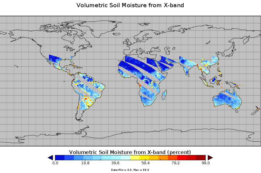
Federal
Spaceborne Imaging Radar-C Precision
National Aeronautics and Space Administration —
Spaceborne Imaging Radar-C/X-band Synthetic Aperture Radar (SIR-C/X-SAR) is a joint project of the National Aeronautics and Space Administration (NASA), the German... -
Federal
Stream water concentrations of herbicides and nutrients for sites in the northern Missouri and southern Iowa region, 1994 to 1999
Department of Agriculture —
The data set contains stream water concentrations of herbicides and nutrients for 153 sites in the northern Missouri/southern Iowa region from 1994 to 1995. The data... -
Federal
United States Climate Reference Network (USCRN) Raw Experimental Datasets
National Oceanic and Atmospheric Administration, Department of Commerce —
The Experimental USCRN data consists of data from four separate locations. Two of these stations--Johnstown, PA and Sterling, VA--were used to establish USCRN data... -
Federal
National Centers for Environmental Prediction-Department of Energy (NCEP-DOE) Atmospheric Model Intercomparison Project (AMIP)-II Reanalysis (Reanalysis-2)
National Oceanic and Atmospheric Administration, Department of Commerce —
The NCEP-DOE Atmospheric Model Intercomparison Project (AMIP-II) reanalysis is a follow-on project to the "50-year" (1948-present) NCEP-NCAR Reanalysis Project. NCEP-... -
Federal
SMAPVEX12 Core-Based In Situ Soil Moisture Data for Agricultural Area V001
National Aeronautics and Space Administration —
This data set contains in situ soil moisture data collected with coring devices at several agricultural sites as part of the Soil Moisture Active Passive Validation... -
Federal
Static soils, climate, hydrologic, topographic, and geographic characteristics for selected Chesapeake Bay watersheds
Department of the Interior —
This dataset contains values of soils, climate, hydrologic, topographic, and other geographic characteristics such as drainage area. These are considered "static"... -
University
Soil Survey Geographic (SSURGO) database for Lea County, New Mexico
Earth Data Analysis Center, University of New Mexico —
This data set is a digital soil survey and generally is the most detailed level of soil geographic data developed by the National Cooperative Soil Survey. The... -
Federal
SMAP L4 Global 3-hourly 9 km EASE-Grid Surface and Root Zone Soil Moisture Geophysical Data V007
National Aeronautics and Space Administration —
SMAP Level-4 (L4) surface and root zone soil moisture data are provided in three products: * SMAP L4 Global 3-hourly 9 km EASE-Grid Surface and Root Zone Soil... -
Federal
SnowEx20 Grand Mesa Autumn 2019 Gravimetric Soil Moisture V001
National Aeronautics and Space Administration —
Gravimetric soil moisture data measured from collected soil samples in autumn 2019 as part of the NASA SnowEx 2020 campaign at Grand Mesa, CO. A total of 77 soil... -
County
Soil Properties - 2018
Fairfax County, Virginia —
Table of properties of soil types. One to many relate with the Soils 2018 layer. -
Federal
Little Bighorn Battlefield National Monument vegetation composition, structure, and soils: 2009–2016 status and trend flat file data summaries
Department of the Interior —
Tabular flat file data summaries used in the Little Bighorn Battlefield National Monument vegetation composition, structure, and soils: 2009–2016 status and trend... -
Federal
Oregon Crest-to-Coast Environmental Monitoring Transect Dataset, including climatic observations and tree growth data
National Oceanic and Atmospheric Administration, Department of Commerce —
The US Environmental Protection Agency - Western Ecology Division (EPA) has been monitoring above- and belowground climate data from 23 locations along an Oregon... -
Federal
Water Availability Tool for Environmental Resources for the Commonwealth of Kentucky updated for 2019 - Land-Cover, Waterbodies and Topography
Department of the Interior —
These data include land-cover, water bodies, and topographic data. -
Federal
Water Availability Tool for Environmental Resources for the Commonwealth of Kentucky updated for 2019 - Climate
Department of the Interior —
Climatic data are from Daymet (Thornton and others, 2016) and include maximum daily air temperature and total daily precipitation on a 1-km resolution; these data... -
Federal
Water Availability Tool for Environmental Resources for the Commonwealth of Kentucky updated for 2019 - Soils
Department of the Interior —
These data include those for soil characteristics and TOPMODEL-specific variables that are derived from soils data. -
Federal
Water Availability Tool for Environmental Resources for Haw Creek, Indiana
Department of the Interior —
The Water Availability Tool for Environmental Resources (WATER-KY; Williamson and others, 2009) provides the ability to simulate streamflow for ungaged basins. This... -
Federal
TMI/TRMM surface soil moisture (LPRM) L3 1 day 25 km x 25 km nighttime V001 (LPRM_TMI_NT_SOILM3) at GES DISC
National Aeronautics and Space Administration —
TMI/TRMM surface soil moisture (LPRM) L3 1 day 25 km x 25 km nighttime V001 is Level 3 (gridded) data set. Its land surface parameters, surface soil moisture, land...

Official websites use .gov
A
.gov website belongs to an official government
organization in the United States.
Secure .gov websites use HTTPS
A
lock (
) or https:// means you’ve safely connected to
the .gov website. Share sensitive information only on official,
secure websites.