
-
Federal
High Altitude MMIC Sounding Radiometer (HAMSR) CPEX-AW V1
National Aeronautics and Space Administration —
The High Altitude MMIC Sounding Radiometer (HAMSR) CPEX-AW dataset includes measurements gathered by the HAMSR instrument during the Convective Processes Experiment –... -
Federal
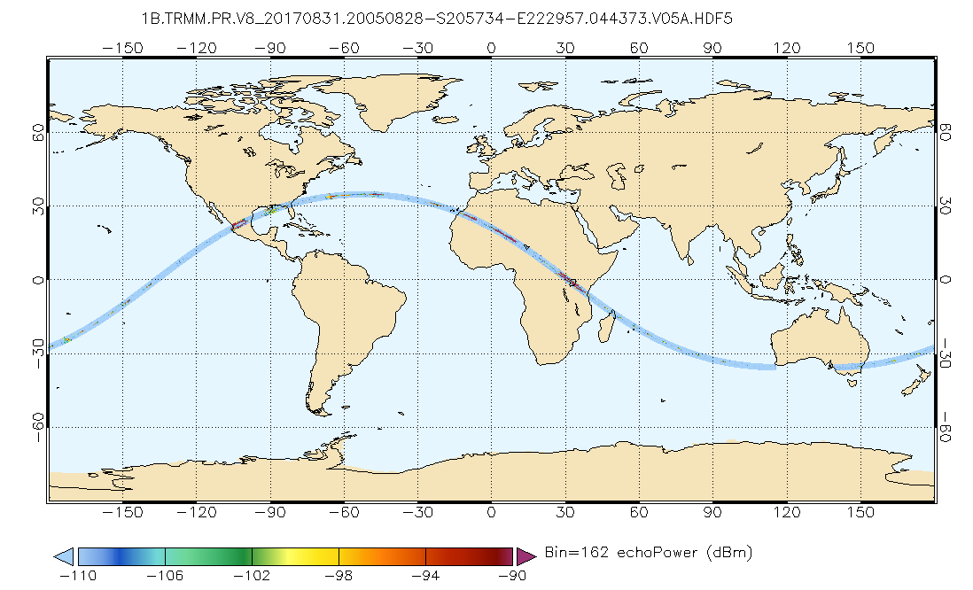
GPM PR on TRMM Echo Power L1B 1.5 hours 5 km V07 (GPM_1BPR) at GES DISC
National Aeronautics and Space Administration —
This is the new (GPM-formated) TRMM product. It replaces the old TRMM_1B21,1C21 Version 07 is the current version of the data set. Previous versions have been... -
Federal
GPM GROUND VALIDATION AIRBORNE SECOND GENERATION PRECIPITATION RADAR (APR-2) GCPEX V1
National Aeronautics and Space Administration —
The GPM Ground Validation Airborne Second Generation Precipitation Radar (APR-2) GCPEx dataset was collected during the GPM Cold-season Precipitation Experiment... -
Federal
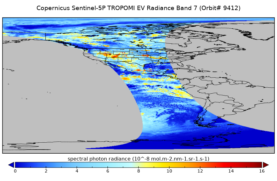
Sentinel-5P TROPOMI Near-Real-Time (NRT) Radiance product band 7 (SWIR detector) L1B 5.5km x 7km V2 (S5P_L1B_RA_BD7_HiR_NRT) at GES DISC
National Aeronautics and Space Administration —
The Sentinel-5P TROPOMI Near Real Time (NRT) Radiance product band 7 (SWIR detector) L1B 5.5km x 21km V2 (S5P_L1B_RA_BD7_HiR_NRT) product at GES DISC is the near real... -
Federal
First ISCCP Regional Experiment (FIRE) Atlantic Stratocumulus Transition Experiment (ASTEX) Rawinsonde Level 1 Data
National Aeronautics and Space Administration —
The First ISCCP Regional Experiments (FIRE) have been designed to improve data products and cloud/radiation parameterizations used in general circulation models... -
Federal
First ISCCP Regional Experiment (FIRE) Arctic Cloud Experiment (ACE) CV580 Aircraft G-Meter Data
National Aeronautics and Space Administration —
This data set consists of light scattering measurements provided by the 4-channel nephelometer g-meter instrument flown onboard the University of Washington's CV580... -
Federal
ACE Definitive Attitude, Hourly Values, Direction Cosines in RTN, GSE, and J2000 GCI Coordinates
National Aeronautics and Space Administration —
ACE Definitive Attitude, Direction Cosines in Radial-Tangential-Normal, RTN, Geocentric Solar Ecliptic, GSE, and J2000 Geocentric Ecliptic, GCI, Coordinates. Data in... -
Federal
First ISCCP Regional Experiment (FIRE) Atlantic Stratocumulus Transition Experiment (ASTEX) Rawinsonde Level 2 Data
National Aeronautics and Space Administration —
The First ISCCP Regional Experiments (FIRE) have been designed to improve data products and cloud/radiation parameterizations used in general circulation models... -
Federal
ROSETTA-ORBITER 67P RSI 1/2/3 COMET ESCORT 1 0505 V1.0
National Aeronautics and Space Administration —
This is a Rosetta Radio Science data set, collected during the COMET ESCORT 1 phase 2014-11-20 to 2015-03-10. It is a Global Gravity measurement at the comet 67P and... -
Federal
ROSETTA-ORBITER 67P RSI 1/2/3 PRELANDING 0278 V1.0
National Aeronautics and Space Administration —
This is a Rosetta Radio Science data set, collected during the PRELANDING phase 2014-01-21 to 2014-11-18. It is a Global Gravity measurement at the comet 67P and... -
Federal
BARREL 4D X-ray Spectrometer (MSPC) Bremsstrahlung X-ray Spectrum Medium Time Resolution, Level 2, 4 s Data
National Aeronautics and Space Administration —
MSPC: 48 channels of medium time resolution, 4 s, Bremsstrahlung X-ray spectra detected with a NaI Scintillator. The nominal energy range covered by the 48 channels... -
Federal
ROSETTA-ORBITER 67P GIADA 3 ESC3 COMET ESCORT 3 V1.0
National Aeronautics and Space Administration —
Comet Escort 3 Phase covers the period of time from 1 July 2015 until 20 October 2015. It started after Rosetta successfully completed the Comet Escort 2 Phase. The... -
Federal
ROSETTA-ORBITER PRELANDING OSINAC 3 RDR MTP003 V2.0
National Aeronautics and Space Administration —
This data set contains images acquired by the OSIRIS Narrow Angle Camera during the PRELANDING phase of the Rosetta mission at the comet 67P, covering the period from... -
Federal
Chandra-COSMOS Bright Source Catalog
National Aeronautics and Space Administration —
COSMOS is an astronomical survey designed to probe the formation and evolution of galaxies as a function of cosmic time (redshift) and large scale structural... -
Federal
AIRS/Aqua L3 8-day CO2 in the free troposphere (AIRS+AMSU) 2.5 degrees x 2 degrees V005 (AIRX3C28) at GES DISC
National Aeronautics and Space Administration —
Atmospheric Infrared Sounder (AIRS) is a grating spectrometer (R = 1200) aboard the second Earth Observing System (EOS) polar-orbiting platform, EOS Aqua. In... -
Federal
BLM ID CADNSDI PLSS Meandered Water
Department of the Interior —
These are areas of water that are defined from meander lines of the PLSS and GLO surveys. These are not the official representations of coast or water lines and are... -
Federal
BLM ID NLCS Historic Wilderness Study Area
Department of the Interior —
Wilderness Study Areas (WSA) for Idaho BLM as they were in 2008 (POLYGONS) This is a HISTORICAL polygon feature class for WSAs in Idaho BLM.... -
Federal
BLM ID Sage Grouse Habitat 2012
Department of the Interior —
The 2012 Sage-grouse Habitat Planning Map update incorporates wildfire data and other edits relevant to the 2012 field and fire season as per typical processes used... -
Federal
BLM ID Sage Grouse Habitat 2014
Department of the Interior —
The 2014 Sage-grouse Habitat Planning Map update incorporates wildfire data and other edits relevant to the 2014 field and fire season as per typical processes used... -
Federal
BLM ID NLCS National Monuments and National Conservation Areas
Department of the Interior —
This feature class displays the exterior boundaries of the Craters of the Moon National Monument and the Morley Nelson Birds of Prey National Conservation Area. For...

Official websites use .gov
A
.gov website belongs to an official government
organization in the United States.
Secure .gov websites use HTTPS
A
lock (
) or https:// means you’ve safely connected to
the .gov website. Share sensitive information only on official,
secure websites.