
-
Federal
MODIS/Terra Calibrated Radiances 5-Min L1B Swath 1km - NRT
National Aeronautics and Space Administration —
The MODIS Level 1B Near Real Time (NRT) data set contains calibrated and geolocated at-aperture radiances for 36 discrete bands located in the 0.4 to 14.4 micron... -
Federal
TRACE-A DC-8 Remotely Sensed Differential Absorption Lidar (DIAL) Data
National Aeronautics and Space Administration —
TRACE-A_AircraftRemoteSensing_DC8_DIAL_Data is the remotely sensed Differential Absorption Lidar (DIAL) data collected onboard the DC-8 aircraft during the Transport... -
Federal
OPERA Land Surface Disturbance Annual from Harmonized Landsat Sentinel-2 product (Version 1)
National Aeronautics and Space Administration —
The Observational Products for End-Users from Remote Sensing Analysis (OPERA) Land Surface Disturbance Annual from... -
Federal
CPEX-AW DAWN Doppler Aerosol WiNd Lidar
National Aeronautics and Space Administration —
CPEXAW-DAWN_DC8_1 are the Doppler Aerosol WiNd lidar (DAWN) image and NetCDF data files collected during the Convective Processes Experiment - Aerosols & Winds... -
Federal
ATom: L2 In Situ Measurements of Aerosol Microphysical Properties (AMP)
National Aeronautics and Space Administration —
This dataset provides the number, surface area, and volume concentrations and size distributions of dry aerosol particles measured by the Aerosol Microphysical... -
Federal
Geostationary Coastal and Air Pollution Events measurements for Geostationary Ocean Color Imager (GOCI)
National Aeronautics and Space Administration —
GEO-CAPE is the Geostationary Coastal and Air Pollution Events program with a focus on the Geostationary Ocean Color Imager (GOCI). -
Federal
SMEX03 Surface and Soil Temperature Measurements: Alabama, Version 1
National Aeronautics and Space Administration —
This data set contains land surface temperature and soil temperature data collected during the Soil Moisture Experiment 2003 (SMEX03) in northern Alabama and southern... -
Federal
Sentinel-1C Dual Polarization Full Resolution Ground Range Detected Product Metadata
National Aeronautics and Space Administration —
The Sentinel-1C satellite was launched December 5, 2024. Sentinel-1C is the the latest satellite to be added to the Sentinel-1 constellation. The Sentinel-1... -
Federal
UARS Improved Stratospheric and Mesospheric Sounder (ISAMS) Level 3AT V010 (UARIS3AT) at GES DISC
National Aeronautics and Space Administration —
The Improved Stratospheric and Mesospheric Sounder (ISAMS) Level 3AT data product consists of daily, 65.536 second interval time-ordered vertical profiles of... -
Federal
HLS Landsat Operational Land Imager Surface Reflectance and TOA Brightness Daily Global 30m v2.0
National Aeronautics and Space Administration —
The Harmonized Landsat Sentinel-2 (HLS) project provides consistent surface reflectance (SR) and top of atmosphere (TOA) brightness data from a virtual constellation... -
Federal
SMAP_L1A_RADAR_RECEIVE_ONLY_QA_V001
National Aeronautics and Space Administration —
SMAP Level 1A Radar Receive Only Data Quality Information Version 1 -
Federal
GHRSST Level 4 OSTIA Global Historical Reprocessed Foundation Sea Surface Temperature Analysis produced by the UK Meteorological Office
National Aeronautics and Space Administration —
The Operational Sea Surface Temperature and Sea Ice Analysis Reprocessed (OSTIA-REP) is a GHRSST reprocessed Level-4 sea surface temperature and ice-concentration... -
Federal
NRT AMSR2 Unified L3 Daily 12.5 km Brightness Temperature & Sea Ice Concentration V4
National Aeronautics and Space Administration —
The Advanced Microwave Scanning Radiometer 2 (AMSR2) instrument on the Global Change Observation Mission - Water 1 (GCOM-W1) provides global passive microwave... -
Federal
Ulysses Heliosphere Instrument for Spectral, Composition, and Anisotropy at Low Energies (HISCALE) LEFS60 Count Rates, 11.5 s Averages
National Aeronautics and Space Administration —
12sec-averaged sectored count rates from LEFS60. The HISCALE instrument contains the Low-Energy Magnetic Spectrometers (LEMS), the Low-Energy Foil Spectrometers... -
Federal
Daymet: Station-Level Inputs and Cross-Validation for North America, Version 4 R1
National Aeronautics and Space Administration —
This dataset reports the station-level daily weather observation data and the corresponding cross-validation results for three Daymet model parameters: minimum... -
Federal
Ground-Based Global Navigation Satellite System (GNSS) Data (1-second sampling, real-time streams) from NASA CDDIS
National Aeronautics and Space Administration —
Global Navigation Satellite System (GNSS) real-time 1 to multi-second sampled data available from the Crustal Dynamics Data Information System (CDDIS). Global... -
Federal
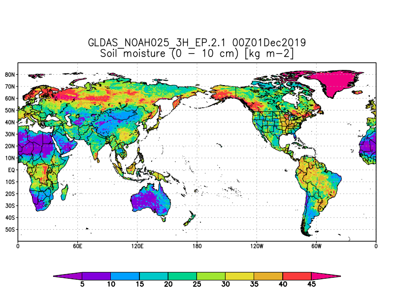
GLDAS Noah Land Surface Model L4 3 hourly 0.25 x 0.25 degree Early Product V2.1 (GLDAS_NOAH025_3H_EP) at GES DISC
National Aeronautics and Space Administration —
NASA Global Land Data Assimilation System Version 2 (GLDAS-2) has three components: GLDAS-2.0, GLDAS-2.1, and GLDAS-2.2. GLDAS-2.0 is forced entirely with the... -
Federal
SWOT Level 2 River Cycle-Averaged Data Product, Version C
National Aeronautics and Space Administration —
Cycle average and aggregation of river reach pass data within predefined hydrological basins. Basin for each cycle. Available in Shapefile file format. Please note... -
Federal
MODIS/Aqua Cloud Properties COSP Level 3 monthly, 1x1 deg. grid
National Aeronautics and Space Administration —
The MODIS/Aqua Cloud Properties COSP Level 3 monthly, 1x1 degree grid product is a new L3 CLDPROP COSP Cloud product with short-name CLDPROPCOSP_M3_MODIS_Aqua. It...

Official websites use .gov
A
.gov website belongs to an official government
organization in the United States.
Secure .gov websites use HTTPS
A
lock (
) or https:// means you’ve safely connected to
the .gov website. Share sensitive information only on official,
secure websites.