
-
Federal
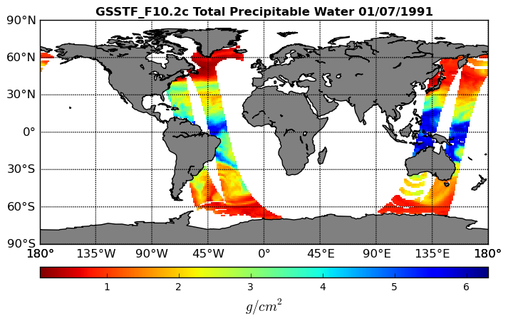
Goddard Satellite-Based Surface Turbulent Fluxes, 1x1 deg Daily Grid, Satellite F10 V2c (GSSTF_F10) at GES DISC
National Aeronautics and Space Administration —
These data are part of the Goddard Satellite-based Surface Turbulent Fluxes Version-2c (GSSTF 2c) Dataset recently produced through a MEaSURES funded project led by... -
Federal
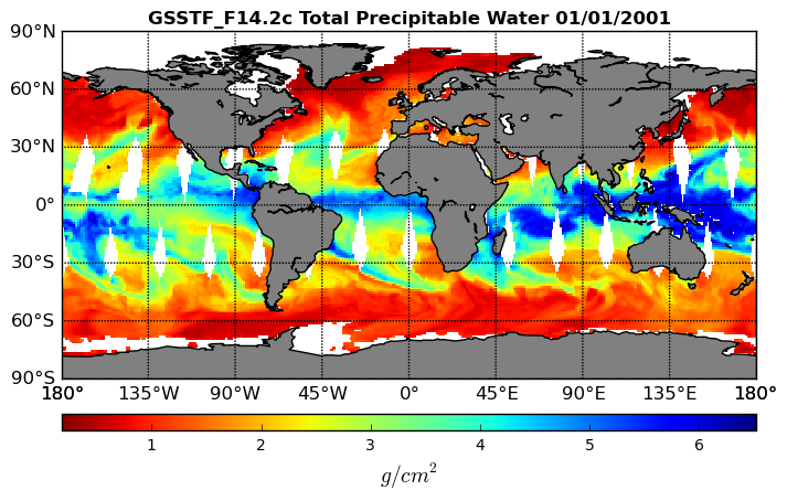
Goddard Satellite-Based Surface Turbulent Fluxes, 0.25 x 0.25 deg, Daily Grid F14 V3 (GSSTF_F14) at GES DISC
National Aeronautics and Space Administration —
These data are part of the Goddard Satellite-based Surface Turbulent Fluxes Version 3 (GSSTF3) Dataset recently produced through a MEaSURES funded project led by Dr.... -
Federal
GHRSST L3C hourly America Region sub-skin Sea Surface Temperature v1.0 from ABI on GOES16 produced by OSISAF
National Aeronautics and Space Administration —
The data is regional and part of the Group for High Resolution Sea Surface Temperature (GHRSST) Level 3 Collated (L3C) dataset covering the America Region based on... -
Federal
ECOSTRESS Tiled Water Use Efficiency Instantaneous L4 Global 70 m V002
National Aeronautics and Space Administration —
The ECOsystem Spaceborne Thermal Radiometer Experiment on Space Station (ECOSTRESS) mission measures the temperature of plants to better understand how much water... -
Federal
GHRSST Level 3U NOAA ACSPO SST v2.80 from VIIRS on NOAA-21 Satellite
National Aeronautics and Space Administration —
The N21-VIIRS-L3U-ACSPO-v2.80 dataset produced by the NOAA ACSPO system derives the Subskin Sea Surface Temperature (SST) from the Visible Infrared Imaging Radiometer... -
Federal
GHRSST Level 3U NOAA STAR SST v2.80 from VIIRS on NOAA-20 Satellite
National Aeronautics and Space Administration —
NOAA-20 (N20/JPSS-1/J1) is the second satellite in the US NOAA latest generation Joint Polar Satellite System (JPSS), launched on November 18, 2017. The ACSPO... -
Federal
First ISCCP Regional Experiment (FIRE) Marine Stratocumulus Ceilometer and Cross-chain Loran Atmospheric Sounding System (CLASS) Data
National Aeronautics and Space Administration —
The First ISCCP Regional Experiments have been designed to improve data products and cloud/radiation parameterizations used in general circulation models (GCMs).... -
Federal
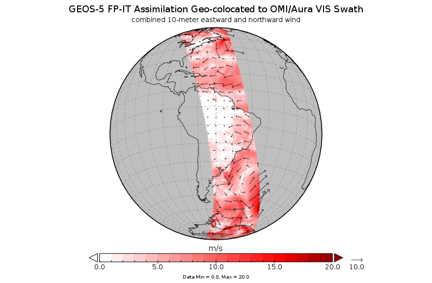
GEOS-5 FP-IT Assimilation Geo-colocated to OMI/Aura VIS 1-Orbit L2 Support Swath 13x24km V3 (OMVFPITMET) at GES DISC
National Aeronautics and Space Administration —
The GEOS-5 FP-IT Assimilation Geo-colocated to OMI/Aura VIS 1-Orbit L2 Support Swath 13x24km (OMVFPITMET) provides selected parameters from GEOS-5 Forward Processing... -
Federal
FIREX-AQ NOAA-CHEM Twin Otter Photolysis Rate (j value) Data
National Aeronautics and Space Administration —
FIREXAQ_jValue_AircraftInSitu_N48_Data are in situ photolysis rate (j value) data collected onboard the NOAA-CHEM Twin Otter aircraft during FIREX-AQ. Data collection... -
Federal
EMIT L1B At-Sensor Calibrated Radiance and Geolocation Data 60 m V001
National Aeronautics and Space Administration —
The Earth Surface Mineral Dust Source Investigation (EMIT) instrument measures surface mineralogy, targeting the Earth’s arid dust source regions. EMIT is installed... -
Federal
Delta-X: Real-Time Kinematic Elevation Measurements for Coastal Wetlands, LA, 2021
National Aeronautics and Space Administration —
This dataset provides real-time kinematic (RTK) GPS elevation measurements, along with horizontal and vertical precision errors, obtained along transects near... -
Federal
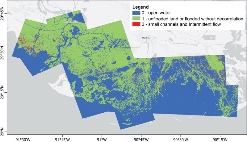
Delta-X: UAVSAR L3 Gridded Open Water Channels, MRD, LA, USA, 2021, V2
National Aeronautics and Space Administration —
This dataset provides gridded estimates of water channels for the Atchafalaya and Terrebonne basins of the Mississippi River Delta in Louisiana, U.S.A. The data show... -
Federal
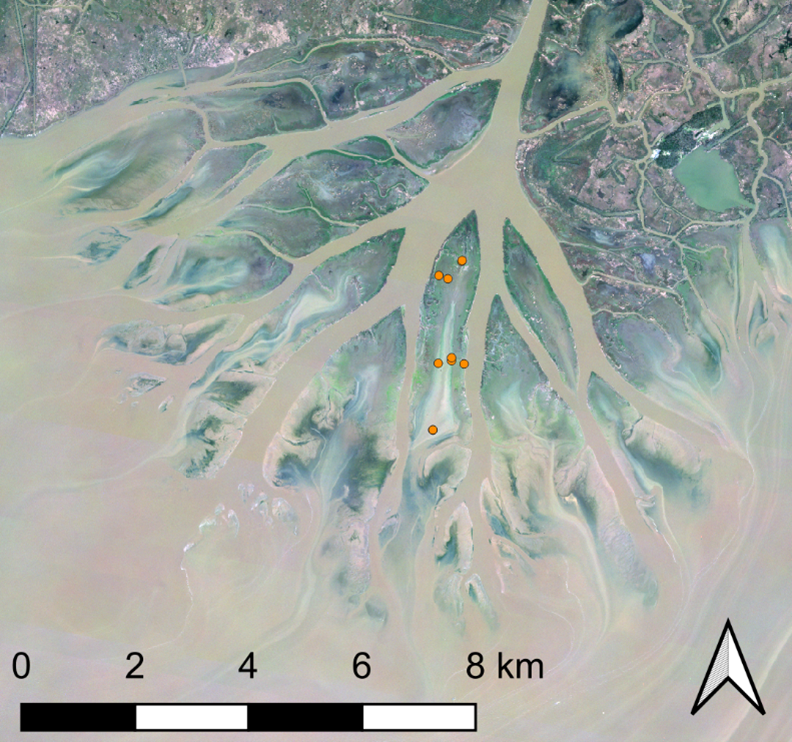
Delta-X: Sediment Core Grain Size Distribution, Wax Lake Delta, MRD, LA
National Aeronautics and Space Administration —
This dataset provides grain size distribution measurements collected from sediment core samples on Mike Island in the Wax Lake Delta, Louisiana, as part of the... -
Federal
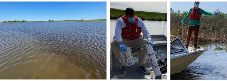
Delta-X: Particulate Organic Carbon Concentration from Water Samples, MRD, LA, 2021
National Aeronautics and Space Administration —
This dataset provides measurements of particulate organic carbon (POC) concentrations made on water samples collected during 2021 in surface waters of the Atchafalaya... -
Federal
PSP Integrated Science Investigation of the Sun, Energetic Particle Instrument-Lo (ISOIS EPI-Lo) Ion Composition, Level 2 (L2), 1 min Data
National Aeronautics and Space Administration —
Parker Solar Probe, PSP, Integrated Science Investigation of the Sun, IS☉IS, Energetic Particle Instrument, EPI-Lo, Ion Composition data: The Epoch time tags indicate... -
Federal
Wind SMS Suite SupraThermal Ion Composition Spectrometer (SMS/STICS) Ion Moments, Level 2 (L2), 3-minute Data in Solar Wind
National Aeronautics and Space Administration —
The data include Wind STICS 3-minute density (0th moment) and mean value of the energy distribution (1st moment), together with their statistical errors, for selected... -
Federal
Wind SMS Suite SupraThermal Ion Composition Spectrometer (SMS/STICS) Ion Moments, Level 2 (L2), 3-minute Data in Magnetosphere
National Aeronautics and Space Administration —
The data include Wind STICS 3-minute density (0th moment) and mean value of the energy distribution (1st moment), together with their statistical errors, for selected... -
Federal
Wind Solar Wind Experiment (SWE) Faraday Cup, Solar Wind Plasma Reduced Ion Distribution Functions, 92 s Data
National Aeronautics and Space Administration —
WIND Solar Wind Experiment, SWE, Faraday cup data: this data set contains three-dimensional measurements of ions in the energy range 150 eV to 8 keV. Placed 15° above... -
Federal
Wind SMS Suite SupraThermal Ion Composition Spectrometer (SMS/STICS) Energy-Resolved Pitch-Angle Distributions (ERPAs), Level 2 (L2), 30-minute Data in Solar Wind
National Aeronautics and Space Administration —
The data include Wind STICS 30-minute Energy-Resolved Pitch-Angle Distributions (ERPAs) for selected ion species using triple coincidence (H+, He+, He2+, C5+, O+,... -
Federal
Wind SMS Suite SupraThermal Ion Composition Spectrometer (SMS/STICS) Energy-Resolved Pitch-Angle Distributions (ERPAs), Level 2 (L2), 30-minute Data in Magnetosphere
National Aeronautics and Space Administration —
The data include Wind STICS 30-minute Energy-Resolved Pitch-Angle Distributions (ERPAs) for selected ion species using triple coincidence (H+, He+, He2+, C5+, O+,...

Official websites use .gov
A
.gov website belongs to an official government
organization in the United States.
Secure .gov websites use HTTPS
A
lock (
) or https:// means you’ve safely connected to
the .gov website. Share sensitive information only on official,
secure websites.