
-
Federal
CRED Subsurface Temperature Recorder (STR); NWHI, PHR; Long: -175.88217, Lat: 27.78245 (WGS84); Sensor Depth: 13.11m; Data Range: 20070805-20080923.
National Oceanic and Atmospheric Administration, Department of Commerce —
Data from Coral Reef Ecosystem Division (CRED), NOAA Pacific Islands Fisheries Science Center (PIFSC) Subsurface Temperature Recorders (STR) provide a time series of... -
Federal
CRED Subsurface Temperature Recorder (STR); NWHI, PHR; Long: -175.97867, Lat: 27.77482 (WGS84); Sensor Depth: 2.00m; Data Range: 20020928-20030801.
National Oceanic and Atmospheric Administration, Department of Commerce —
Data from Coral Reef Ecosystem Division (CRED), NOAA Pacific Islands Fisheries Science Center (PIFSC) Subsurface Temperature Recorders (STR) provide a time series of... -
Federal
CRED Subsurface Temperature Recorder (STR); CNMI, SAR; Long: 145.76789, Lat: 16.71058 (WGS84); Sensor Depth: 6.10m; Data Range: 20050918-20070524.
National Oceanic and Atmospheric Administration, Department of Commerce —
Data from Coral Reef Ecosystem Division (CRED), NOAA Pacific Islands Fisheries Science Center (PIFSC) Subsurface Temperature Recorders (STR) provide a time series of... -
Federal
CRED Subsurface Temperature Recorder (STR); PRIA, PAL; Long: -162.08589, Lat: 05.88622 (WGS84); Sensor Depth: 3.35m; Data Range: 20080403-20100408.
National Oceanic and Atmospheric Administration, Department of Commerce —
Data from Coral Reef Ecosystem Division (CRED), NOAA Pacific Islands Fisheries Science Center (PIFSC) Subsurface Temperature Recorders (STR) provide a time series of... -
Federal
Benthic Habitat of Lanai Derived From IKONOS and Quick Bird Satellite Imagery, 2004-2006
National Oceanic and Atmospheric Administration, Department of Commerce —
This project is a cooperative effort between the National Ocean Service, National Centers for Coastal Ocean Science, Center for Coastal Monitoring and Assessment, the... -
Federal
CRED Subsurface Temperature Recorder (STR); Palmyra Atoll, Pacific Remote Island Areas; Long: -162.12811, Lat: 05.89639 (WGS84); Sensor Depth: 11.30m; Data Date Range: 20100408-20110823.
National Oceanic and Atmospheric Administration, Department of Commerce —
Data from Coral Reef Ecosystem Division (CRED), NOAA Pacific Islands Fisheries Science Center (PIFSC) Subsurface Temperature Recorders (STR) provide a time series of... -
Federal
CRED Sea Surface Temperature (SST) Buoy; AMSM, TUT; Long: -170.72266, Lat: -14.28457 (WGS84); Sensor Depth: 0.33m; Data Range: 20080220-20100222.
National Oceanic and Atmospheric Administration, Department of Commerce —
Data from Coral Reef Ecosystem Division (CRED), NOAA Pacific Islands Fisheries Science Center (PIFSC) Sea Surface Temperature (SST) Buoys provide a time series of... -
Federal
CRED Subsurface Temperature Recorder (STR); CNMI, AGU; Long: 145.53723, Lat: 14.84778 (WGS84); Sensor Depth: 8.23m; Data Range: 20070518-20090410.
National Oceanic and Atmospheric Administration, Department of Commerce —
Data from Coral Reef Ecosystem Division (CRED), NOAA Pacific Islands Fisheries Science Center (PIFSC) Subsurface Temperature Recorders (STR) provide a time series of... -
Federal
CRED Subsurface Temperature Recorder (STR); Palmyra Atoll, Pacific Remote Island Areas; Long: -162.06183, Lat: 05.88276 (WGS84); Sensor Depth: 4.60m; Data Date Range: 20100411-20120516.
National Oceanic and Atmospheric Administration, Department of Commerce —
Data from Coral Reef Ecosystem Division (CRED), NOAA Pacific Islands Fisheries Science Center (PIFSC) Subsurface Temperature Recorders (STR) provide a time series of... -
Federal
CRED Subsurface Temperature Recorder (STR); PRIA, BAK; Long: -176.47474, Lat: 00.18797 (WGS84); Sensor Depth: 2.40m; Data Range: 20040124-20040728.
National Oceanic and Atmospheric Administration, Department of Commerce —
Data from Coral Reef Ecosystem Division (CRED), NOAA Pacific Islands Fisheries Science Center (PIFSC) Subsurface Temperature Recorders (STR) provide a time series of... -
Federal
CRED Subsurface Temperature Recorder (STR); Saipan, Commonwealth of the Northern Mariana Islands; Long: 145.72255, Lat: 15.23748 (WGS84); Sensor Depth: 5.79m; Data Date Range: 20090414-20110406.
National Oceanic and Atmospheric Administration, Department of Commerce —
Data from Coral Reef Ecosystem Division (CRED), NOAA Pacific Islands Fisheries Science Center (PIFSC) Subsurface Temperature Recorders (STR) provide a time series of... -
Federal
CRED Subsurface Temperature Recorder (STR); MHI, LEH; Long: -160.09705, Lat: 22.01453 (WGS84); Sensor Depth: 6.40m; Data Range: 20081109-20101028.
National Oceanic and Atmospheric Administration, Department of Commerce —
Data from Coral Reef Ecosystem Division (CRED), NOAA Pacific Islands Fisheries Science Center (PIFSC) Subsurface Temperature Recorders (STR) provide a time series of... -
Federal
Benthic Habitats of Kauai Derived From IKONOS and Quick Bird Satellite Imagery, 2004-2006
National Oceanic and Atmospheric Administration, Department of Commerce —
This project is a cooperative effort between the National Ocean Service, National Centers for Coastal Ocean Science, Center for Coastal Monitoring and Assessment, the... -
Federal
CRED Subsurface Temperature Recorder (STR); NWHI, PHR; Long: -175.86494, Lat: 27.94438 (WGS84); Sensor Depth: 35.36m; Data Range: 20070805-20080923.
National Oceanic and Atmospheric Administration, Department of Commerce —
Data from Coral Reef Ecosystem Division (CRED), NOAA Pacific Islands Fisheries Science Center (PIFSC) Subsurface Temperature Recorders (STR) provide a time series of... -
Federal
CRED Subsurface Temperature Recorder (STR); NWHI, MID; Long: -177.36784, Lat: 28.27774 (WGS84); Sensor Depth: 0.30m; Data Range: 20020926-20030727.
National Oceanic and Atmospheric Administration, Department of Commerce —
Data from Coral Reef Ecosystem Division (CRED), NOAA Pacific Islands Fisheries Science Center (PIFSC) Subsurface Temperature Recorders (STR) provide a time series of... -
Federal
CRED Subsurface Temperature Recorder (STR); PRIA, JAR; Long: -159.99110, Lat: -00.36323 (WGS84); Sensor Depth: 9.80m; Data Range: 20040328-20060320.
National Oceanic and Atmospheric Administration, Department of Commerce —
Data from Coral Reef Ecosystem Division (CRED), NOAA Pacific Islands Fisheries Science Center (PIFSC) Subsurface Temperature Recorders (STR) provide a time series of... -
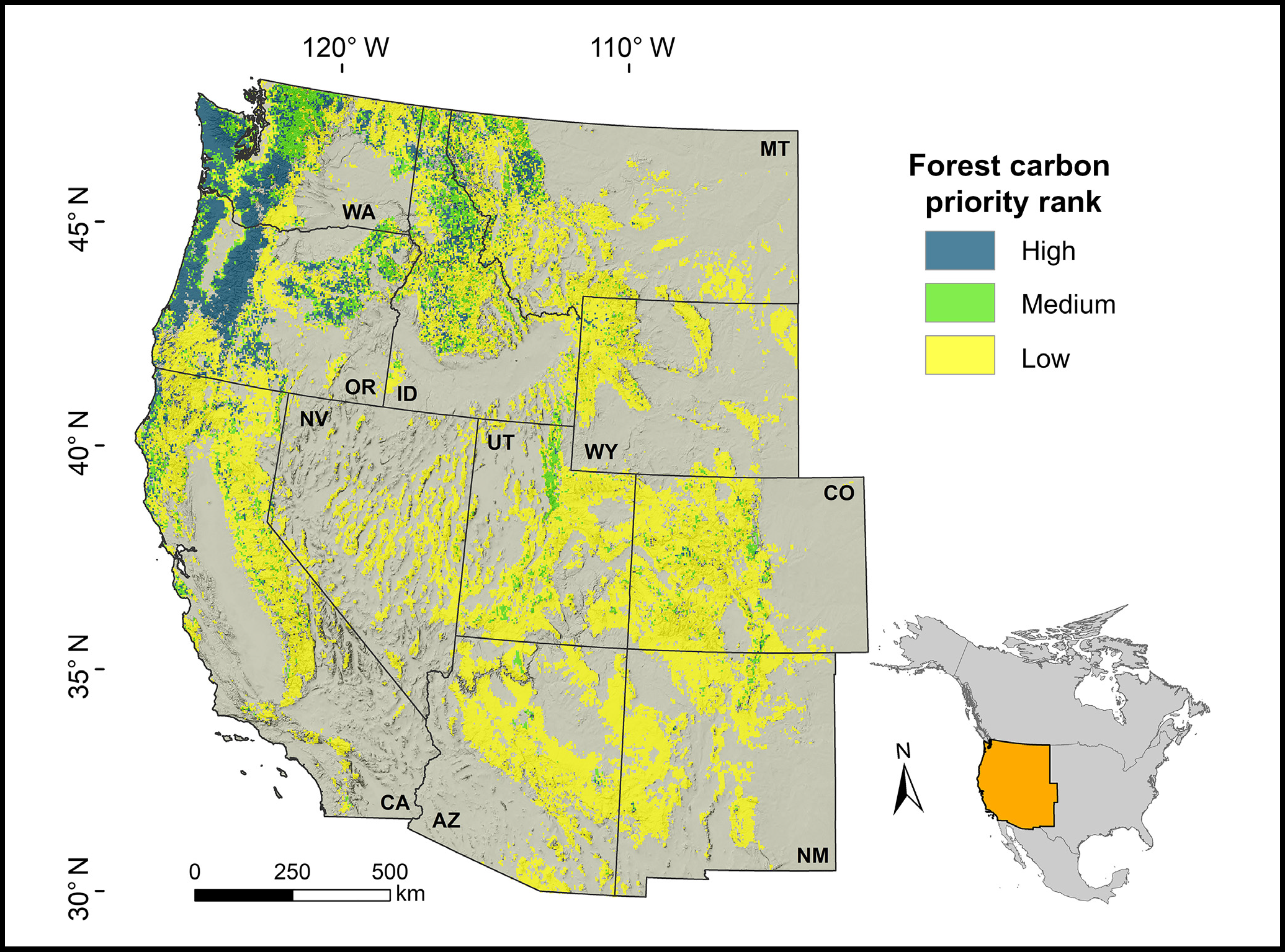
Federal
Forest Preservation Ranking and Vertebrate Species Richness, Western USA, 2020-2099
National Aeronautics and Space Administration —
This dataset provides related gridded outputs of future modeled forest carbon sequestration priority and related species richness and habitat suitability for the...

Official websites use .gov
A
.gov website belongs to an official government
organization in the United States.
Secure .gov websites use HTTPS
A
lock (
) or https:// means you’ve safely connected to
the .gov website. Share sensitive information only on official,
secure websites.