
-
Federal
Oahu Hyperspectral Imagery 2000 (202-0612-272217) - Visual Interpretation from Remote Sensing Imagery Main Eight Hawaiian Islands
National Oceanic and Atmospheric Administration, Department of Commerce —
This project is a cooperative effort between the National Ocean Service, National Centers for Coastal Ocean Science, Center for Coastal Monitoring and Assessment, the... -
Federal
Oahu Hyperspectral Imagery 2000 (204c-0613-332211) - Visual Interpretation from Remote Sensing Imagery Main Eight Hawaiian Islands
National Oceanic and Atmospheric Administration, Department of Commerce —
This project is a cooperative effort between the National Ocean Service, National Centers for Coastal Ocean Science, Center for Coastal Monitoring and Assessment, the... -
Federal
Oahu Photomosaic 2000 (213-214w-0516) - Orthorectification and Mosaicing of Color Aerial Photography Main Eight Hawaiian Islands
National Oceanic and Atmospheric Administration, Department of Commerce —
Habitat maps of the main Hawaiian Islands were created by visual interpretation of aerial photos and hyperspectral imagery using the Habitat Digitizer extension.... -
Federal
Benthic Habitats of Puerto Rico and the U.S. Virgin Islands; Photomosaic of Puerto Rico (San Juan), 1999
National Oceanic and Atmospheric Administration, Department of Commerce —
Habitat maps of Puerto Rico and the U.S. Virgin Islands were created by visual interpretation of aerial photographs using the Habitat Digitizer Extension. Aerial... -
Federal
4 km NODC/RSMAS AVHRR Pathfinder v5.0 and Interim v5.0 Sea Surface Temperature (SST) Data and v5.1 SST Data for 1981-2009
National Oceanic and Atmospheric Administration, Department of Commerce —
The 4 km Pathfinder effort at the National Oceanic and Atmospheric Administration (NOAA) National Oceanographic Data Center (NODC) and the University of Miami's... -
Federal
CRED Cumulative Map of Percent Scleractinian Coral Cover at Zealandia
National Oceanic and Atmospheric Administration, Department of Commerce —
This map displays optical validation observation locations and percent coverage of scleractinian coral overlaid on bathymetry. -
Federal
2011 NOAA Ortho-rectified Mosaic of the Port of Mobile (NODC Accession 0106341)
National Oceanic and Atmospheric Administration, Department of Commerce —
This data set contains ortho-rectified mosaic tiles, created as a product from the NOAA Integrated Ocean and Coastal Mapping (IOCM) initiative. The source imagery was... -
Federal
CRED Cumulative Map of Percent Scleractinian Coral Cover at Thirty Five Fathom Bank, Commonwealth of Northern Mariana Islands, USA
National Oceanic and Atmospheric Administration, Department of Commerce —
This map displays optical validation observation locations and percent coverage of scleractinian coral overlaid on bathymetry. -
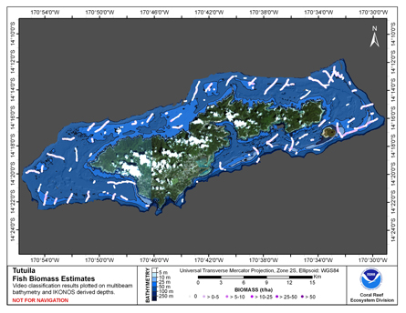
Federal
CRED Cumulative Fish Biomass map at Tutuila Island
National Oceanic and Atmospheric Administration, Department of Commerce —
This map displays fish biomass observation locations overlaid on bathymetry. -
Federal
1970's Mosaic of Aerial Photography of the Salt River Bay National Historical Park and Ecological Preserve, St. Croix, USVI
National Oceanic and Atmospheric Administration, Department of Commerce —
Aerial photographs taken by NOAA's National Geodetic Survey during 1977 and 1971 were mosaicked and orthorectified by the Biogeography Program resulting in a single... -
Federal
Benthic Habitats of Puerto Rico and the U.S. Virgin Islands; Photomosaic of U.S. Virgin Islands (St. John), 1999
National Oceanic and Atmospheric Administration, Department of Commerce —
Habitat maps of Puerto Rico and the U.S. Virgin Islands were created by visual interpretation of aerial photographs using the Habitat Digitizer Extension. Aerial... -
Federal
ESI-VI2, Christiansted, St. Croix, U.S. Virgin Islands 2000 (Environmental Sensitivity Index Map)
National Oceanic and Atmospheric Administration, Department of Commerce —
Environmental Sensitivity Index (ESI) maps are an integral component in oil-spill contingency planning and assessment. They serve as a source of information in the... -
Federal
Molokai Photomosaic 2000 (326n-0601) - Orthorectification and Mosaicing of Color Aerial Photography for the Main Eight Hawaiian Islands
National Oceanic and Atmospheric Administration, Department of Commerce —
Habitat maps of the main Hawaiian Islands were created by visual interpretation of aerial photos and hyperspectral imagery using the Habitat Digitizer extension.... -
Federal
Molokai Photomosaic 2000 (328w-0516) - Orthorectification and Mosaicing of Color Aerial Photography Main Eight Hawaiian Islands
National Oceanic and Atmospheric Administration, Department of Commerce —
Habitat maps of the main Hawaiian Islands were created by visual interpretation of aerial photos and hyperspectral imagery using the Habitat Digitizer extension.... -
Federal
NCCOS Mapping: Characterizing Benthic Habitats West of Saipan, Commonwealth of the Northern Mariana Islands (CNMI), 2018-11-05 to 2022-04-29 (NCEI Accession 0291792)
National Oceanic and Atmospheric Administration, Department of Commerce —
This data package contains information and maps showing the geology and biology of select submerged lands (0 to 40 meters deep) offshore of western Saipan,... -
Federal
ESI-PR64, Guayama, Puerto Rico 2000 (Environmental Sensitivity Index Map)
National Oceanic and Atmospheric Administration, Department of Commerce —
Environmental Sensitivity Index (ESI) maps are an integral component in oil-spill contingency planning and assessment. They serve as a source of information in the... -
Federal
Manua Islands IKONOS Imagery - IKONOS Imagery for American Samoa
National Oceanic and Atmospheric Administration, Department of Commerce —
This project is a cooperative effort among the National Ocean Service, National Centers for Coastal Ocean Science, Center for Coastal Monitoring and Assessment; the... -
Federal
Niihau IKONOS and Quickbird Imagery - Mosaic
National Oceanic and Atmospheric Administration, Department of Commerce —
This project is a cooperative effort between the National Ocean Service, National Centers for Coastal Ocean Science, Center for Coastal Monitoring and Assessment, BAE... -
Federal
CRED Map of Percent Hard Coral Cover at Tutuila Island, American Samoa
National Oceanic and Atmospheric Administration, Department of Commerce —
This map displays optical validation observation locations and percent coverage of hard coral overlaid on bathymetry. -
Federal
2011 NOAA Ortho-rectified Mosaic of Yabucoa, Puerto Rico (NODC Accession 0074381)
National Oceanic and Atmospheric Administration, Department of Commerce —
This data set contains ortho-rectified mosaic tiles, created as a product from the NOAA Integrated Ocean and Coastal Mapping (IOCM) initiative. The source imagery was...

Official websites use .gov
A
.gov website belongs to an official government
organization in the United States.
Secure .gov websites use HTTPS
A
lock (
) or https:// means you’ve safely connected to
the .gov website. Share sensitive information only on official,
secure websites.