

42,608 datasets found for "Water Features"
-
Federal
Oahu Hyperspectral Imagery 2000 (201-0611-272217), Hyperspectral Imagery for the Main Eight Hawaiian Islands
National Oceanic and Atmospheric Administration, Department of Commerce —
This project is a cooperative effort between the National Ocean Service, National Centers for Coastal Ocean Science, Center for Coastal Monitoring and Assessment, the... -
Federal
Oahu Hyperspectral Imagery 2000 (212-0612-332211) - Visual Interpretation from Remote Sensing Imagery Main Eight Hawaiian Islands
National Oceanic and Atmospheric Administration, Department of Commerce —
This project is a cooperative effort between the National Ocean Service, National Centers for Coastal Ocean Science, Center for Coastal Monitoring and Assessment, the... -
Federal
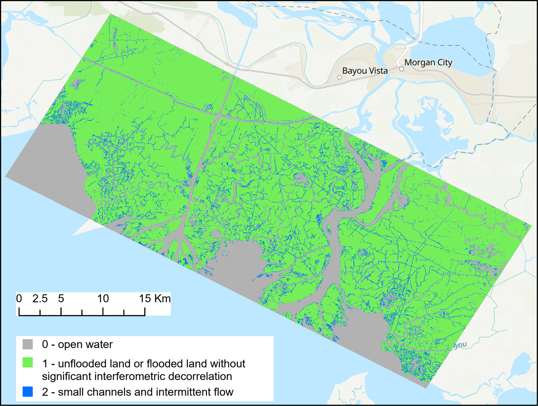
Pre-Delta-X: UAVSAR Georeferenced Channel Maps, Atchafalaya Basin, LA, USA, 2016, V2
National Aeronautics and Space Administration —
This dataset provides spatial data on water channels in the estuary of the Atchafalaya Basin of the Mississippi River Delta of coastal Louisiana. These Level-3 (L3)... -
Federal
FIFE CDROM Vol. 3 Contents: NS001 Thematic Mapper Simulator (TMS) Imagery, 1987-1989
National Aeronautics and Space Administration —
This data set provides aircraft-based NS001 Thematic Mapper Simulator (TMS) images of the study area associated with The First ISLSCP (International Satellite Land... -
Federal
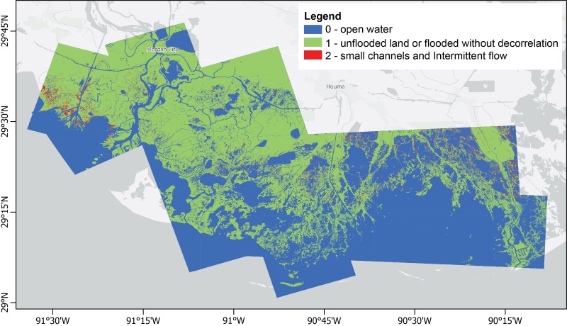
Delta-X: UAVSAR L3 Gridded Open Water Channels, MRD, LA, USA, 2021, V2
National Aeronautics and Space Administration —
This dataset provides gridded estimates of water channels for the Atchafalaya and Terrebonne basins of the Mississippi River Delta in Louisiana, U.S.A. The data show... -
Federal
JERS-1 Synthetic Aperture Radar, 100-m Mosaics, South America: 1995-1996, R1
National Aeronautics and Space Administration —
This data set provides ~100-m resolution image mosaics of South America acquired during the low flood season between September and December 1995 and during the high... -
Federal
TIGER/Line Shapefile, Current, County, Fulton County, KY, Topological Faces-Area Hydrography Relationship File
U.S. Census Bureau, Department of Commerce —
The TIGER/Line shapefiles and related database files (.dbf) are an extract of selected geographic and cartographic information from the U.S. Census Bureau's Master... -
Federal
TIGER/Line Shapefile, Current, State, Connecticut, 2020 Census Blocks with Suffixes
U.S. Census Bureau, Department of Commerce —
The TIGER/Line shapefiles and related database files (.dbf) are an extract of selected geographic and cartographic information from the U.S. Census Bureau's Master...
42,608 datasets found for "Water Features"