
-
Federal
Ground-Based Global Navigation Satellite System (GNSS) GPS real-time POD Orbits (60-second sampling, 60-second files) from NASA CDDIS
National Aeronautics and Space Administration —
This product contains a time series of position and velocity components for healthy satellites in the GPS constellation that are accumulated every minute throughout... -
Federal
Ground-Based Global Navigation Satellite System (GNSS) GLONASS real-time POD Clock Corrections (1-second sampling, 60-second files) from NASA CDDIS
National Aeronautics and Space Administration —
This product contains a high-rate time series of clock biases for healthy satellites in the GLONASS constellation that are accumulated every minute throughout the... -
Federal
Global Sentinel-1 Burst ID Map
National Aeronautics and Space Administration —
Sentinel-1 performs systematic acquisition of bursts in both IW and EW modes. The bursts overlap almost perfectly between different passes and are always located at... -
Federal
Global Navigation Satellite Systems (GNSS) Real-Time Orbit Products from NASA CDDIS
National Aeronautics and Space Administration —
Precise satellite orbits derived from analysis of Global Navigation Satellite System (GNSS) data. Analysis Centers (ACs) of the International GNSS Service (IGS)... -
Federal
Global Navigation Satellite System (GNSS) Final Orbit Products from NASA CDDIS
National Aeronautics and Space Administration —
Precise satellite orbits derived from analysis of Global Navigation Satellite System (GNSS) data. Analysis Centers (ACs) of the International GNSS Service (IGS)... -
Federal
AIRS/Aqua L1B Near Real Time (NRT) Infrared (IR) geolocated and calibrated radiances V005 (AIRIBRAD_NRT) at GES DISC
National Aeronautics and Space Administration —
WARNING: On 2021/09/23 the EOS Aqua executed a Deep Space Maneuver (DSM). In the DSM, the spacecraft is turned such that the normal Earth field of regard is deep... -
Federal
VIIRS/NOAA20 Deep Blue Aerosol L2 6-Min Swath 6 km
National Aeronautics and Space Administration —
The VIIRS/NOAA20 Deep Blue Aerosol L2 6-Min Swath 6 km product from the Visible Infrared Imaging Radiometer Suite (VIIRS) determines atmospheric aerosol loading for... -
Federal
Very Long Baseline Interferometry (VLBI) Earth Orientation Parameters (EOP) Products from NASA CDDIS
National Aeronautics and Space Administration —
These derived data products are intensive (1-hour experiments) and series Earth orientation parameter (EOPI and EOPS, respectively) solutions obtained with Very Long... -
Federal
Very Long Baseline Interferometry (VLBI) Positions Products from NASA CDDIS
National Aeronautics and Space Administration —
Station positions and velocity solutions in Software INdependent EXchange (SINEX) format derived from analysis of Very Long Baseline Interferometry (VLBI) data. These... -
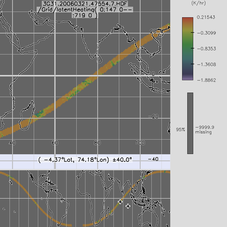
Federal
TRMM TMI/PR Combined Gridded Orbital Spectral Latent Heating L3 1.5 hours 0.5 degree x 0.5 degree V7 (TRMM_3G31) at GES DISC
National Aeronautics and Space Administration —
3G31, Gridded Orbital Convective Stratiform Heating from Combined, produces 0.5 degree x 0.5 degree orbital apparent heating profiles from surface convective rainfall... -
Federal
Terra MODIS Level-3 Global Binned 4µm Nighttime Sea Surface Temperature (SST4) Data, version R2019.0
National Aeronautics and Space Administration —
MODIS (or Moderate-Resolution Imaging Spectroradiometer) is a key instrument aboard the Terra (EOS AM) and Aqua (EOS PM) satellites. Terra's orbit around the Earth is... -
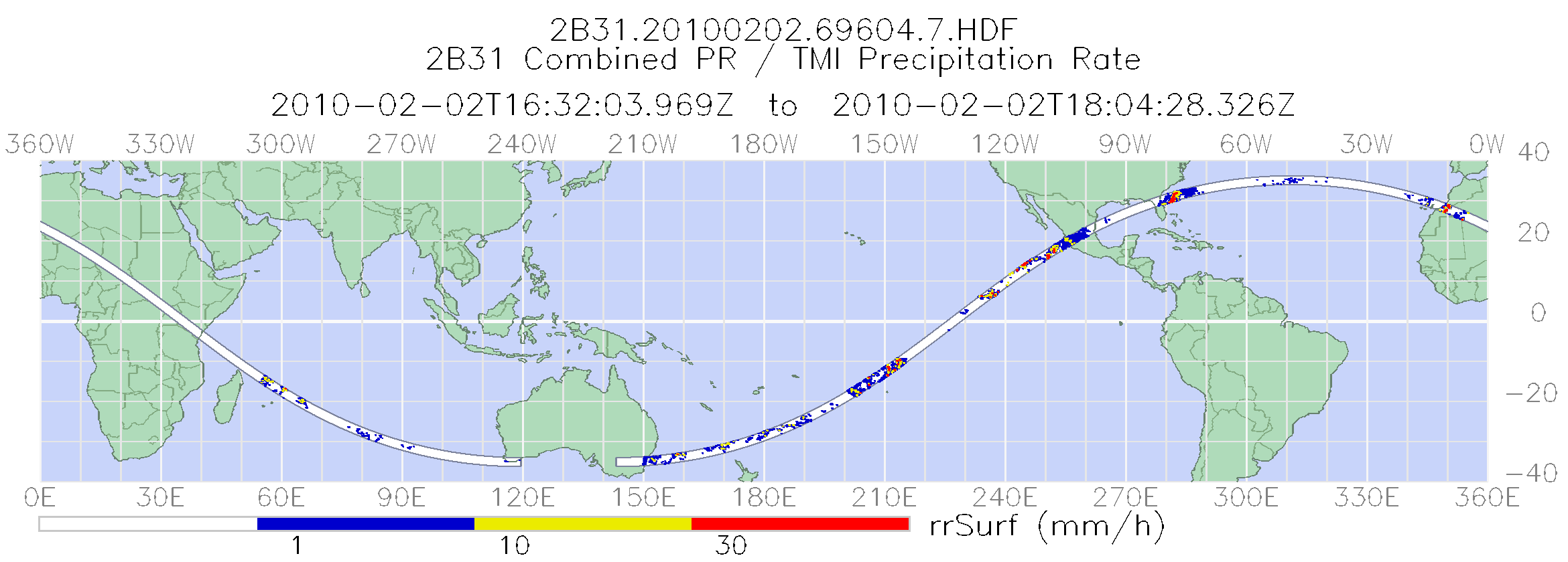
Federal
TRMM Combined Precipitation Radar and Microwave Imager Rainfall Profile L2 1.5 hours V7 (TRMM_2B31) at GES DISC
National Aeronautics and Space Administration —
This is the last version of the TRMM-formatted, in HDF4 format, Combined (Radar-Radiometer) product, which is in a state of permanent preservation. New version that... -
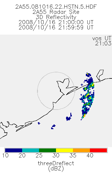
Federal
TRMM Ground Validation Radar Site 3D Reflectivity L2 1 hour V7 (TRMM_2A55) at GES DISC
National Aeronautics and Space Administration —
'Radar Site 3-D Reflectivities', is composed of 3 different fields. The first field has an array of 3-D reflectivities in Cartesian coordinates with a 2 km horizontal... -
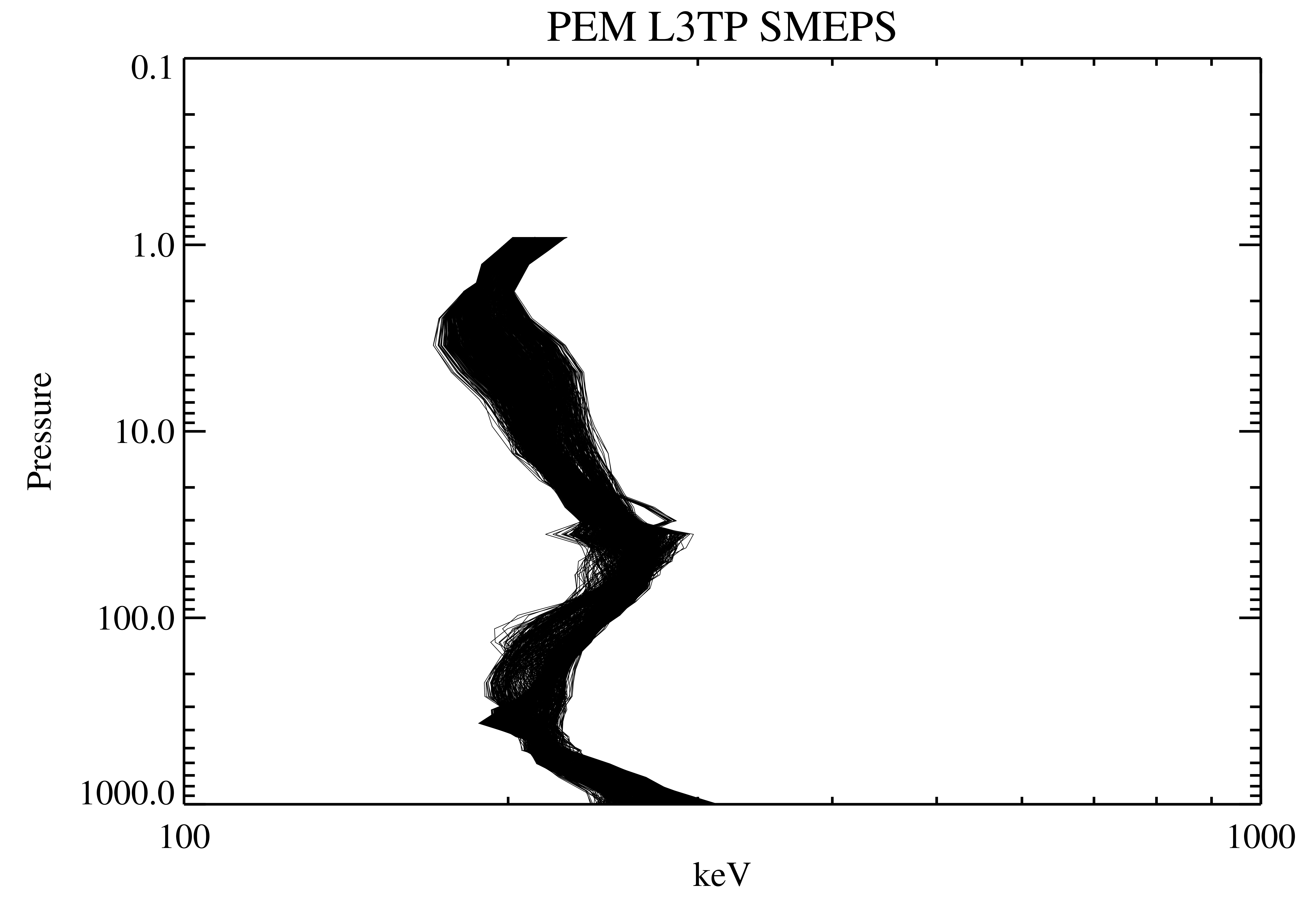
Federal
UARS PEM Level 2 AXIS 2 V001 (UARPE2AXIS2) at GES DISC
National Aeronautics and Space Administration —
The UARS Particle Environment Monitor (PEM) level 2 Atmosphere X-Ray Imaging Spectrometer (AXIS) unit 2 daily product contains the X-ray high-resolution spectral data... -
Federal
TRMM Microwave Imager Precipitation Profile L3 1 month 0.5 degree x 0.5 degree V7 (TRMM_3A12) at GES DISC
National Aeronautics and Space Administration —
The new equivalent for this dataset should be searched for as "GPM_3GPROFTRMMTMI_CLIM". This product contains global monthly means of surface precipitation rate, rain... -
Federal
TRMM PR Gridded Orbital Spectral Latent Heating Profiles L3 1.5 hours 0.5 degree x 0.5 degree V7 (TRMM_3G25) at GES DISC
National Aeronautics and Space Administration —
3G25, "Gridded Orbital Spectral Latent Heating", produces 0.5 degree x 0.5 degree latent heating, Q1-QR, and Q2 profiles from Precipitation Radar (PR) rain. The... -
Federal
UAVSAR_INSAR_KMZ
National Aeronautics and Space Administration —
UAVSAR Repeat Pass Interferometry Scene KMZ -
Federal
TRMM Radar Rainfall Statistics L3 1 month (5 x 5) and (0.5 x 0.5) degree V7 (TRMM_3A25) at GES DISC
National Aeronautics and Space Administration —
The new version of these data is in GPM-like format (consistent with the GPM Dual-frequency Radar data format), and can be found under the name GPM_3PR. This product... -
Federal
Terra MODIS Level-3 Global Mapped 4µm Nighttime Sea Surface Temperature (SST4) Data, version R2019.0
National Aeronautics and Space Administration —
MODIS (or Moderate-Resolution Imaging Spectroradiometer) is a key instrument aboard the Terra (EOS AM) and Aqua (EOS PM) satellites. Terra's orbit around the Earth is...

Official websites use .gov
A
.gov website belongs to an official government
organization in the United States.
Secure .gov websites use HTTPS
A
lock (
) or https:// means you’ve safely connected to
the .gov website. Share sensitive information only on official,
secure websites.