
-
Federal
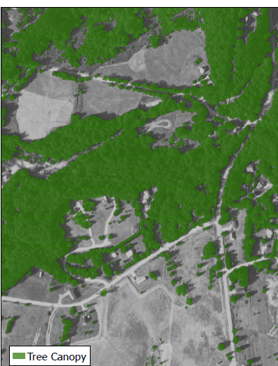
CMS: Tree Canopy Cover at 0.5-meter resolution, Vermont, 2016
National Aeronautics and Space Administration —
This dataset contains estimates of tree canopy cover presence at high resolution (0.5m) across the state of Vermont for 2016 in Cloud-Optimized GeoTIFF (*.tif)... -
Federal
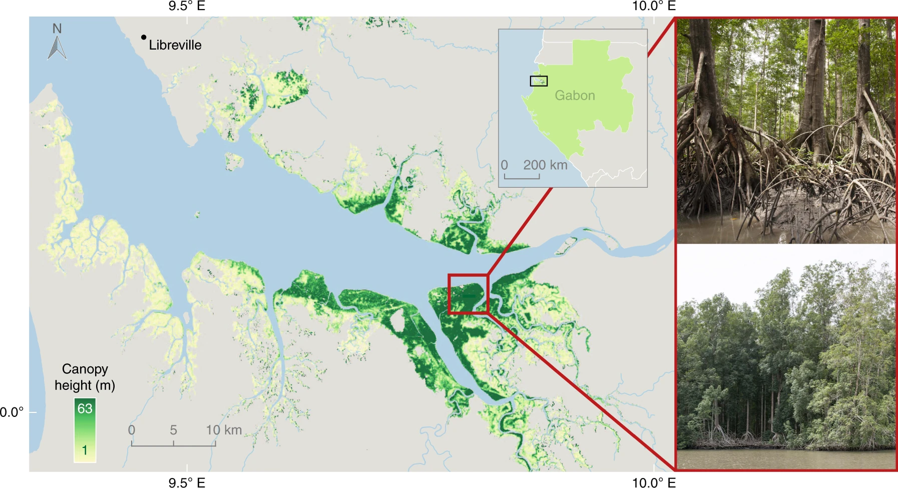
CMS: Global Mangrove Canopy Height Maps Derived from TanDEM-X, 2015
National Aeronautics and Space Administration —
This dataset characterizes canopy heights of mangrove-forested wetlands globally for 2015 at 12-m resolution. Estimates of maximum canopy height (height of the... -
Federal
BOREAS TE-19 Ecosystem Carbon Balance Model
National Aeronautics and Space Administration —
The BOREAS TE-19 team developed a model called the Spruce and Moss Model (SPAM) designed to simulate the daily carbon balance of a black spruce/moss boreal forest... -
Federal
BOREAS RSS-17 Xylem Flux Density Measurements at the SSA-OBS Site
National Aeronautics and Space Administration —
As part of its efforts to determine environmental and phenological states from radar imagery, the BOREAS RSS-17 team collected in situ tree xylem flow measurements... -
Federal
BOREAS TE-12 SSA Shoot Geometry Data
National Aeronautics and Space Administration —
The BOREAS TE-12 team collected shoot geometry data in 1993 and 1994 from Aspen, Jack Pine, and Black Spruce trees. Collections were made at the Southern Study Area... -
Federal
BOREAS TE-07 Dendrology Data
National Aeronautics and Space Administration —
The BOREAS TE-07 team collected data sets in support of its efforts to characterize and interpret information on the sapflow and dendrology of boreal vegetation. This... -
Federal
BOREAS TE-09 NSA Leaf Chlorophyll Density Data
National Aeronautics and Space Administration —
The Boreal Ecosystem-Atmosphere Study (BOREAS) Terrestrial Ecology Team #9 (TE-09) provided several data sets containing information about the state and response of... -
Federal
BOREAS TE-02 Root Respiration Data
National Aeronautics and Space Administration —
The BOREAS TE-02 team collected several data sets in support of its efforts to characterize and interpret information on the respiration of the foliage, roots, and... -
Federal
BOREAS TE-09 PAR & Leaf Nitrogen Data for NSA, R1
National Aeronautics and Space Administration —
The BOREAS TE-09 team collected several data sets related to chemical and photosynthetic properties of leaves in boreal forest tree species. This data set describes... -
Federal
Biomass of Sacrificed Spruce/Aspen (SNF)
National Aeronautics and Space Administration —
The purpose of the SNF study was to improve our understanding of the relationship between remotely sensed observations and important biophysical parameters in the... -
Federal
BOREAS HYD-03 1996 Tree Stem Density Data
National Aeronautics and Space Administration —
The BOREAS HYD-03 team collected several data sets related to the hydrology of forested areas. This data set contains measurements of stem density from a variety of... -
Federal
BOREAS TGB-08 Starch Concentration Data over the SSA-OBS and the SSA-OJP
National Aeronautics and Space Administration —
The TGB-08 team collected data to investigate the controls over non-methane hydrocarbon (NMHC) fluxes from boreal forest tree species. This data set includes... -
Federal
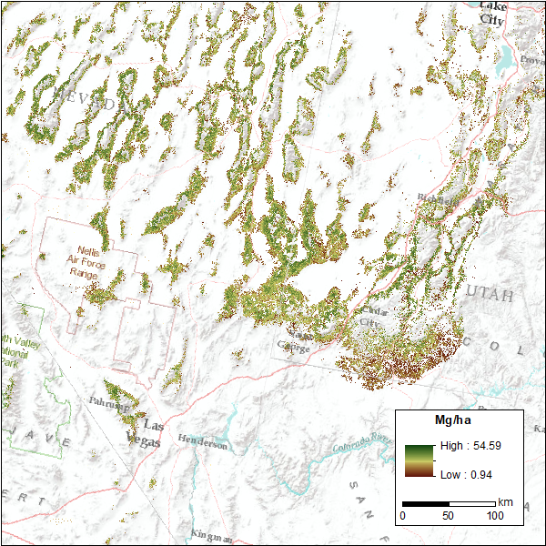
CMS: Pinyon-Juniper Forest Live Aboveground Biomass, Great Basin, USA, 2000-2016
National Aeronautics and Space Administration —
This dataset provides annual maps of live aboveground tree biomass (Mg/ha) for pinyon-juniper forests across the Great Basin of the Western USA for the years... -
Federal
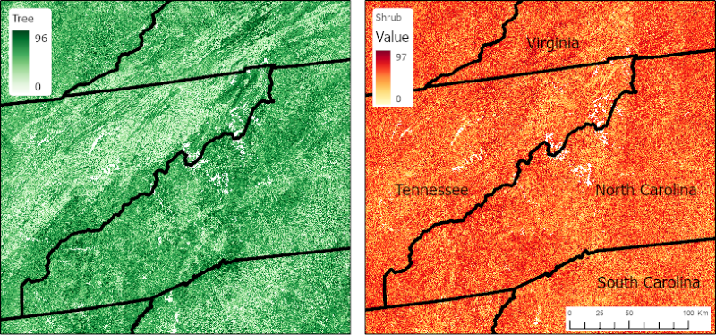
CMS: Vegetative Lifeform Cover from Landsat SR for CONUS, 1984-2018
National Aeronautics and Space Administration —
This dataset contains estimates of percent cover of tree, shrub, herb, and other (non-vegetation) lifeform classes and uncertainties for the conterminous U.S.... -
Federal
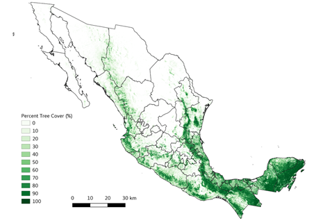
Tree Cover Estimates at 30 m Resolution for Mexico, 2016-2018
National Aeronautics and Space Administration —
The data set provides multi-year (2016-2018) percent tree cover (TC) estimates for entire Mexico at 30 m spatial resolution. The TC data (hereafter, NEX-TC) was... -
Federal
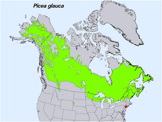
Spruce Leaf, Tree Traits, and Respiration at Range Extremes, AK and NY, USA, 2018
National Aeronautics and Space Administration —
This dataset provides in situ measurements of needle-level gas-exchange and leaf traits from Picea glauca (white spruce) from a field site located in the northern... -
Federal
SNF Forest Phenology/Leaf Expansion Data
National Aeronautics and Space Administration —
The purpose of the SNF study was to improve understanding of the relationship between remotely sensed observations and important biophysical parameters in the boreal... -
State
Vegetation - San Felipe Valley Wildlife Area [ds172]
State of California —
This Vegetation Map of the San Felipe Valley Wildlife Area in San Diego County, California is based on vegetation samples collected in the field in 2002 and 2005 and... -
Federal
Productivity of U.S. Rangelands, Annual Data Z-scores (Image Service)
Department of Agriculture —
This raster dataset depicts rangelands in the coterminous U.S., including transitional rangelands and small patch-size rangelands. Each 30 meter pixel is assigned a... -
City
TAP21 bg Seattle - Possible TC - Vegetation (%)
City of Seattle —
This data layer references data from a high-resolution tree canopy change-detection layer for Seattle, Washington. Tree canopy change was mapped by using remotely...

Official websites use .gov
A
.gov website belongs to an official government
organization in the United States.
Secure .gov websites use HTTPS
A
lock (
) or https:// means you’ve safely connected to
the .gov website. Share sensitive information only on official,
secure websites.