
-
Federal
BOREAS Follow-On DSP-01 Landsat TM Land Cover Mosaic of the BOREAS Transect
National Aeronautics and Space Administration —
The objective of this land cover mosaic is to provide a data product that characterizes the detailed land cover of a significant portion of the BOREAS Region. Seven... -
Federal
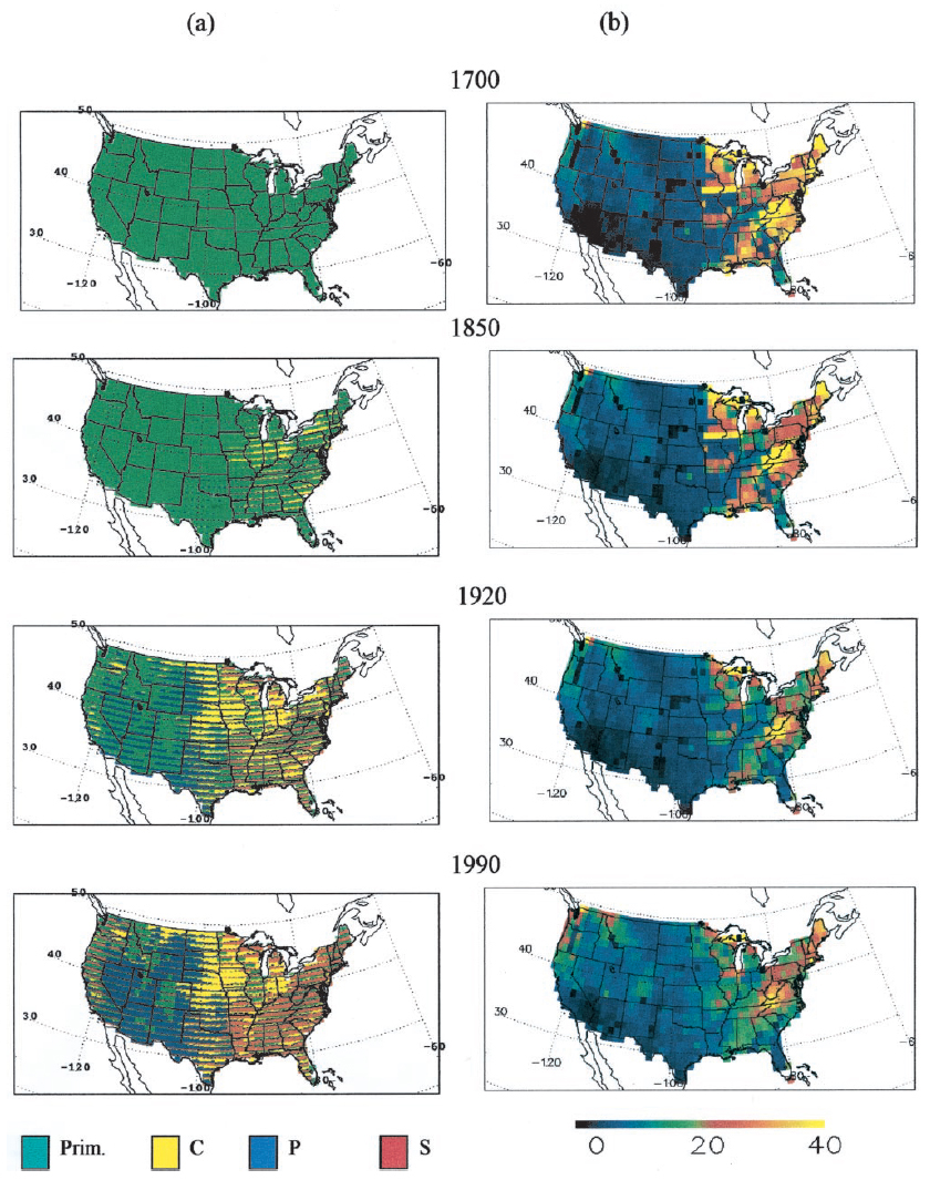
Ecosystem Demography Model: U.S. Ecosystem Carbon Stocks and Fluxes, 1700-1990
National Aeronautics and Space Administration —
This model product contains the source code for the Ecosystem Demography Model (ED version 1.0) as well as model input and output data files for the conterminous... -
Federal
BOREAS Follow-On DSP-10 Reclassified Regridded TM Mosaic Land Cover Maps, 1994
National Aeronautics and Space Administration —
These images were produced by aggregating a reclassified version of the 30-m land cover Thematic Mapper classification by CCRS and are now available at multiple... -
Federal
BOREAS Follow-On DSP-10 Regridded TM Mosaic Land Cover Maps for 1994
National Aeronautics and Space Administration —
Existing 30-m land cover Thematic Mapper classification by CCRS was aggregated and reprocessed and are now available at multiple resolutions (10x5 minutes and 30... -
Federal
BOREAS Follow-On DSP-10 Regridded Land Cover Maps for 1994
National Aeronautics and Space Administration —
These images were produced by aggregating the 1-km land cover classification by Lou Steyaert at multiple resolutions (2 km, 10x5 minutes, and 0.5 degree). These data... -
Federal
BOREAS Follow-On DSP-10 Regridded Moss Cover Maps for 1994
National Aeronautics and Space Administration —
Existing 1-km moss cover classifications were reprocessed and are now available at multiple resolutions (2 km, 10x5 min, and 0.5 degree). These data were regridded... -
Federal
BOREAS Follow-On DSP-09 Moss Cover Classification at Three Area Scales
National Aeronautics and Space Administration —
BOREAS follow-on group DSP-9 mapped surface moss type at three scales (1 km, 30 m, and 10 m) based on observed associations between moss cover and land cover type. -
Federal
Ecosystem Demography Model: U.S. Ecosystem Carbon Stocks and Fluxes, 1700-1990
National Aeronautics and Space Administration —
This model product contains the source code for the Ecosystem Demography Model (ED version 1.0) as well as model input and output data files for the conterminous... -
Federal
Lund-Potsdam-Jena Wetland Hydrology and Methane DGV Model (LPJ-WHyMe v1.3.1)
National Aeronautics and Space Administration —
This model product provides the Fortran 77 source code for the Lund-Potsdam-Jena (LPJ) Wetland Hydrology and Methane Dynamic Global Vegetation Model (LPJ-WHyMe... -
Federal
BOREAS Follow-On DSP-10 Regridded Moss Cover Maps for 1994
National Aeronautics and Space Administration —
Existing 1-km moss cover classifications were reprocessed and are now available at multiple resolutions (2 km, 10x5 min, and 0.5 degree). These data were regridded... -
Federal
OPERA Land Surface Disturbance Annual from Harmonized Landsat Sentinel-2 product (Version 1)
National Aeronautics and Space Administration —
The Observational Products for End-Users from Remote Sensing Analysis (OPERA) Land Surface Disturbance Annual from Harmonized Landsat Sentinel-2 (HLS) product Version... -
Federal
BOREAS Follow-On DSP-01 NBIOME Level-4 AVHRR Land Cover, Canada, Ver. 1.1, 1995
National Aeronautics and Space Administration —
This land cover product was produced by NBIOME to generate an up-to-date, spatially and temporally consistent land cover map of the landmass of Canada for use by... -
Federal
BOREAS Follow-On DSP-10 Regridded Land Cover Maps for 1994
National Aeronautics and Space Administration —
These images were produced by aggregating the 1-km land cover classification by Lou Steyaert at multiple resolutions (2 km, 10x5 minutes, and 0.5 degree). These data... -
Federal
BOREAS Follow-On DSP-10 Regridded TM Mosaic Land Cover Maps for 1994
National Aeronautics and Space Administration —
Existing 30-m land cover Thematic Mapper classification by CCRS was aggregated and reprocessed and are now available at multiple resolutions (10x5 minutes and 30... -
Federal
BOREAS Follow-On DSP-10 Reclassified Regridded TM Mosaic Land Cover Maps, 1994
National Aeronautics and Space Administration —
These images were produced by aggregating a reclassified version of the 30-m land cover Thematic Mapper classification by CCRS and are now available at multiple... -
Federal
Near Real-Time MODIS/Terra L3 Global Daily 500m SIN Grid Snow Cover, Grain Size, and Dust Radiative Forcing, Version 1 NGDA
National Aeronautics and Space Administration —
This data set represents an updated version of the MODIS Snow Covered Area and Grain-size (MODSCAG) and MODIS Dust Radiative Forcing in Snow (MODDRF) data sets...

Official websites use .gov
A
.gov website belongs to an official government
organization in the United States.
Secure .gov websites use HTTPS
A
lock (
) or https:// means you’ve safely connected to
the .gov website. Share sensitive information only on official,
secure websites.