
-
Federal
Global BUFR Data Stream: Ships and Buoy Observations from National Weather Service Telecommunications Gateway (NWS TG)
National Oceanic and Atmospheric Administration, Department of Commerce —
These are raw ship and buoy (moored and drifting) observations provided by World Meteorological Organization (WMO) Member States. Data are transmitted through the WMO... -
Federal
Obsolete - AFSC/RACE/EcoFOCI: 2010 Chukchi Acoustics, Oceanography, and Zooplankton (CHAOZ) Study - 1AE10
National Oceanic and Atmospheric Administration, Department of Commerce —
Data collected on this cruise included the following: acoustic recordings of marine species detected by sonobuoys; oceanographic measurements including water... -
Federal
EK80 Water Column Sonar Data Collected During PC1803
National Oceanic and Atmospheric Administration, Department of Commerce —
During the PC-18-03 cruise, four moorings were turned around, whereby existing moorings and their instrumentation were recovered, and replaced by new and identical... -
Federal
EM304 Water Column Sonar Data Collected During EX2105
National Oceanic and Atmospheric Administration, Department of Commerce —
From August 15- September 2, 2021, NOAA Ocean Exploration conducted mapping operations on the Blake Plateau within U.S. waters, aiding in closing the gaps within this... -
Federal
EK60 Water Column Sonar Data Collected During SE1104
National Oceanic and Atmospheric Administration, Department of Commerce —
Kona Integrated Ecosystem Assessment Survey (SE1104, EK60). This cruise accomplished the following objectives: Oceanographic data were collected from a total of 25... -
Federal
First ISCCP Regional Experiment (FIRE) Atlantic Stratocumulus Transition Experiment (CIRRUS 2) NASA ER-2 Cloud Lidar System Data
National Aeronautics and Space Administration —
The First ISCCP Regional Experiments have been designed to improve data products and cloud/radiation parameterizations used in general circulation models (GCMs).... -
Federal
EM302 Water Column Sonar Data Collected During FA160006
National Oceanic and Atmospheric Administration, Department of Commerce —
Fugro Americas Transit (FA160006). EM302 Data collected during Fugro Americas Transit, data types .all bathy and backscatter and .wcd watercolumn. Data for Seabed... -
Federal
MuSLI Multi-Source Land Surface Phenology Yearly North America 30 m V011
National Aeronautics and Space Administration —
The Multi-Source Land Surface Phenology (LSP) Yearly North America 30 meter (m) Version 1.1 product (MSLSP) provides a Land Surface Phenology product for North... -
Federal
NAAMES R/V Atlantis Navigational and Meteorological In Situ Data, Version 1
National Aeronautics and Space Administration —
NAAMES_MetNav_ShipInSitu_Data are in situ meteorological and navigational measurements collected onboard the R/V Atlantis vessel during the North Atlantic Aerosols... -
Federal
NAAMES C-130 Aircraft In-Situ Radiation Data
National Aeronautics and Space Administration —
NAAMES_Radiation_AircraftInSitu_Data is the North Atlantic Aerosols and Marine Ecosystems Study (NAAMES) in-situ radiation data collected onboard the C-130 aircraft... -
Federal
SASSIE Arctic Field Campaign Summary Ice Concentration Rankings from ML analysis of SBAND Images Fall 2022
National Aeronautics and Space Administration —
This dataset contains ice concentration rankings of S-band images from the S-BAND marine navigation radar collected during the 2022 Salinity and Stratification at the... -
Federal
SASSIE Arctic Field Campaign L1 Wave Glider Data Fall 2022
National Aeronautics and Space Administration —
The Salinity and Stratification at the Sea Ice Edge (SASSIE) project is a NASA experiment that aims to understand how salinity anomalies in the upper ocean generated... -
Federal
SASSIE Arctic Field Campaign Shipboard Thermosalinograph Data Fall 2022 Version 1
National Aeronautics and Space Administration —
The Salinity and Stratification at the Sea Ice Edge (SASSIE) project is a NASA experiment that aims to understand how salinity anomalies in the upper ocean generated... -
Federal
VIIRS/NPP Land Surface Phenology Yearly L3 Global 500m SIN Grid V002
National Aeronautics and Space Administration —
The NASA/NOAA Suomi National Polar-orbiting Partnership (Suomi NPP) Visible Infrared Imaging Radiometer Suite (VIIRS) Land Surface Phenology data product provides... -
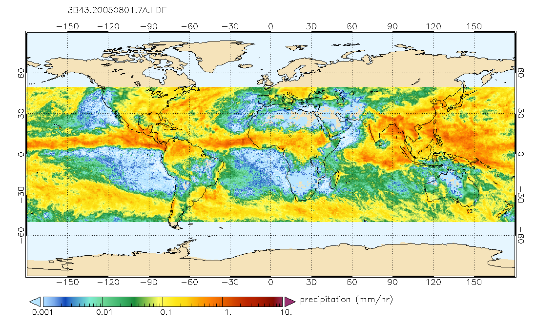
Federal
TRMM (TMPA/3B43) Rainfall Estimate L3 1 month 0.25 degree x 0.25 degree V7 (TRMM_3B43) at GES DISC
National Aeronautics and Space Administration —
TMPA (3B43) dataset have been discontinued as of Dec. 31, 2019, and users are strongly encouraged to shift to the successor IMERG dataset (doi:... -
Federal
TRMM (TMPA) Rainfall Estimate L3 3 hour 0.25 degree x 0.25 degree V7 (TRMM_3B42) at GES DISC
National Aeronautics and Space Administration —
TMPA (3B42) dataset have been discontinued as of Dec. 31, 2019, and users are strongly encouraged to shift to the successor IMERG dataset (doi:... -
Federal
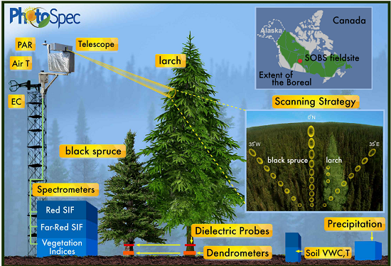
Tower-based PhotoSpec Products for the 2019 and 2020 Spring Transition Season, SK, CA
National Aeronautics and Space Administration —
This dataset includes daily averaged solar-induced chlorophyll fluorescence (SIF) in the red (680-686 nm) and far-red (745-758 nm) wavelength ranges, relative SIF... -
Federal
OWLETS-2 Ozonesonde Data
National Aeronautics and Space Administration —
OWLETS2_Sondes_Data_1 is the Ozone Water-Land Environmental Transition Study (OWLETS-1) ozone data collected via synchronous ozonesonde launches at the Howard... -
Federal
OWLETS-1 Surface Lidar Data
National Aeronautics and Space Administration —
OWLETS1_SurfaceLidar_Data_1 is the Ozone Water-Land Environmental Transition Study (OWLETS-1) lidar data collected at the NASA Langley Research Center ground site and...

Official websites use .gov
A
.gov website belongs to an official government
organization in the United States.
Secure .gov websites use HTTPS
A
lock (
) or https:// means you’ve safely connected to
the .gov website. Share sensitive information only on official,
secure websites.