

42,014 datasets found for "Base Maps"
-
Federal
Unpublished Digital Pre-Hurricane Sandy Geomorphological Map of Fire Island National Seashore and Vicinity, New York (NPS, GRD, GRI, FIIS, FIIS pre-Hurricane Sandy digital map) adapted from a Rutgers University, Institute of Marine and Coastal Sciences map by Psuty, Patel, Freeman, Schmelz, Robertson and Spahn (2014)
Department of the Interior —
**THIS NEWER 2016 DIGITAL MAP REPLACES THE OLDER 2014 VERSION OF THE GRI FIIS Pre-Hurricane Sandy Map. The Unpublished Digital Pre-Hurricane Sandy Geomorphological... -
Federal
H11993: NOS Hydrographic Survey , Sukkwan Narrows, Alaska, 2008-11-10
National Oceanic and Atmospheric Administration, Department of Commerce —
The National Oceanic and Atmospheric Administration (NOAA) has the statutory mandate to collect hydrographic data in support of nautical chart compilation for safe... -
Federal
H11692: NOS Hydrographic Survey , West of Prince of Wales Island, Alaska, 2007-07-27
National Oceanic and Atmospheric Administration, Department of Commerce —
The National Oceanic and Atmospheric Administration (NOAA) has the statutory mandate to collect hydrographic data in support of nautical chart compilation for safe... -
Federal
Unpublished Digital Geologic Map of Katmai National Park and Preserve, and Alagnak Wild River and Vicinity, Alaska (NPS, GRD, GRI, KATM, KATM digital map) adapted from a USGS Unpublished map by Wilson (2009), a NPS Geologic Resources Inventory Unpublished map by Hults (2016), USGS Open File Report maps by Hawley (2004), Wilson, et al. (2006) and Pilcher (1999), a USGS Bulletin map by Detterman and Reed (1980), a Smithsonian Institution map by Venzke (2013) and an ADDGS map by Cameron and Nye (2014)
Department of the Interior —
The Unpublished Digital Geologic Map of Katmai National Park and Preserve, and Alagnak Wild River and Vicinity, Alaska is composed of GIS data layers and GIS tables... -
Federal
Unpublished Digital Geologic Map of Colonial National Historical Park and Vicinity, Virginia (NPS, GRD, GRI, COLO, COLO digital map) adapted from a Virginia Division of Geology and Mineral Resources Geologic Map by Berquist (2015)
Department of the Interior —
The Unpublished Digital Geologic Map of Colonial National Historical Park and Vicinity, Virginia is composed of GIS data layers and GIS tables in a 10.1 file... -
Federal
Unpublished Digital Geologic-GIS Map of Hovenweep National Monument and Vicinity, Colorado and Utah (NPS, GRD, GRI, HOVE, HOVE digital map) adapted from Geologic Resources Inventory unpublished mapping by Poole (2000), and a U.S. Geological Survey Map by Haynes, Vogel and Wyant (1972)
Department of the Interior —
The Unpublished Digital Geologic-GIS Map of Hovenweep National Monument, Colorado and Utah is composed of GIS data layers and GIS tables in a 10.1 file geodatabase... -
Federal
Digital Geologic-GIS Map of Tuzigoot National Monument, Arizona (NPS, GRD, GRI, TUZI, TUZI digital map) adapted from a U.S. Geological Survey Bulletin map by Lehner (1958)
Department of the Interior —
The Unpublished Digital Geologic-GIS Map of Tuzigoot National Monument, Arizona is composed of GIS data layers and GIS tables in a 10.1 file geodatabase... -
Federal
Unpublished Digital Geologic Map of Timucuan Ecological and Historic Preserve, and Fort Caroline National Memorial, Florida (NPS, GRD, GRI, TIMU, FOCA, TIFO digital map) adapted from a Florida Geological Survey preliminary digital data and map by Williams, Cichon, Hartman and Apolinar (2014)
Department of the Interior —
The Unpublished Digital Geologic Map of Timucuan Ecological and Historic Preserve, and Fort Caroline National Memorial, Florida is composed of GIS data layers and GIS... -
Federal
Unpublished Digital Geomorphic Map of Timucuan Ecological and Historic Preserve, and Fort Caroline National Memorial, Florida (NPS, GRD, GRI, TIMU, FOCA, TIFG digital map) adapted from Florida Geological Survey preliminary digital data and map by Williams, Cichon, Hartman and Apolinar (2014)
Department of the Interior —
The Unpublished Digital Geomorphic Map of Timucuan Ecological and Historic Preserve, and Fort Caroline National Memorial, Florida is composed of GIS data layers and... -
Federal
Unpublished Digital Surficial Geologic-GIS Map of the Sandy Hook and Longbranch Quadrangles and Vicinity, New Jersey (NPS, GRD, GRI, GATE, SHSF digital map) adapted from a New Jersey Geological Survey Open-file Maps by Stanford, S.D. (1995, 1999, 2000, 2002)
Department of the Interior —
The Unpublished Digital Surficial Geologic-GIS Map of the Sandy Hook and Longbranch Quadrangles and Vicinity, New Jersey is composed of GIS data layers and GIS tables... -
Federal
Unpublished Digital Surficial Geologic-GIS Map of Gateway National Recreation Area and Vicinity, New Jersey and New York (NPS, GRD, GRI, GATE, GWSF digital map) adapted from a New Jersey Geological Survey Digital Geodata Series map by Pristas, R. P. (2007) and a New York State Museum Map and Chart Series map by Cadwell, D.H., Connally, G.G., Dineen, R.J., Fleisher, P.J., Fuller, M.L., Sirkin, L., and Wiles, G.C. (1999)
Department of the Interior —
The Unpublished Digital Surficial Geologic-GIS Map of Gateway National Recreation Area and Vicinity, New Jersey and New York is composed of GIS data layers and GIS... -
Federal
Unpublished Digital Bedrock Geologic-GIS Map of the Sandy Hook and Longbranch Quadrangles, New Jersey (NPS, GRD, GRI, GATE, SHBR digital map) adapted from a New Jersey Geological Survey Open-file Map by Stanford, S.D., and Sugarman, P.J. (2010) and a U.S. Geological Survey Bulletin map by Minard, J.P. (1969)
Department of the Interior —
The Unpublished Digital Bedrock Geologic-GIS Map of the Sandy Hook and Longbranch Quadrangles, New Jersey is composed of GIS data layers and GIS tables in a 10.1 file... -
Federal
Unpublished Digital Geomorphic Map of the Shackleford Banks, North Carolina (NPS, GRD, GRI, CALO, SHKB digital map) adapted from a East Carolina University unpublished report and GIS data map by Riggs, Ames and Mallinson (2015)
Department of the Interior —
The Unpublished Digital Geomorphic Map of the Shackleford Banks, North Carolina is composed of GIS data layers and GIS tables in a 10.1 file geodatabase... -
Federal
Unpublished Digital Geologic Map of Bering Land Bridge NP and Vicinity, Alaska (NPS, GRD, GRI, BELA, BELA digital map) adapted from a USGS Open File Report and Scientific Investigations maps by Hudson (1998), Williams (2000) and Till (2010, 2011) and a USGS Unpublished map by Wilson (1999)
Department of the Interior —
The Unpublished Digital Geologic Map of Bering Land Bridge National Preserve and Vicinity, Alaska is composed of GIS data layers and GIS tables in a 10.1 file... -
Federal
Digital Surficial Geologic-GIS Map of Tuzigoot National Monument, Arizona (NPS, GRD, GRI, TUZI, CLAR digital map) adapted from a Arizona Geological Survey Open-File Report map by House and Pearthree (1993)
Department of the Interior —
The Unpublished Digital Surficial Geologic-GIS Map of Tuzigoot National Monument, Arizona is composed of GIS data layers and GIS tables in a 10.1 file geodatabase... -
Federal
Unpublished Digital Post-Hurricane Sandy (2015) Geomorphological Map of Fire Island National Seashore and Vicinity, New York (NPS, GRD, GRI, FIIS, FIIS post-Hurricane Sandy digital map) adapted from a Rutgers University, Institute of Marine and Coastal Sciences map by Psuty, Schmelz, Greenberg, Beal and Spahn (2015)
Department of the Interior —
The Unpublished Digital Post-Hurricane Sandy (2015) Geomorphological Map of Fire Island National Seashore and Vicinity, New York is composed of GIS data layers and... -
Federal
SAFARI 2000 Cloud Physics Lidar (CPL) Quicklook Images and Maps
National Aeronautics and Space Administration —
The effect of clouds and aerosols on regional and global climate is of great importance. Two longstanding elements of the NASA climate and radiation science program... -
Federal
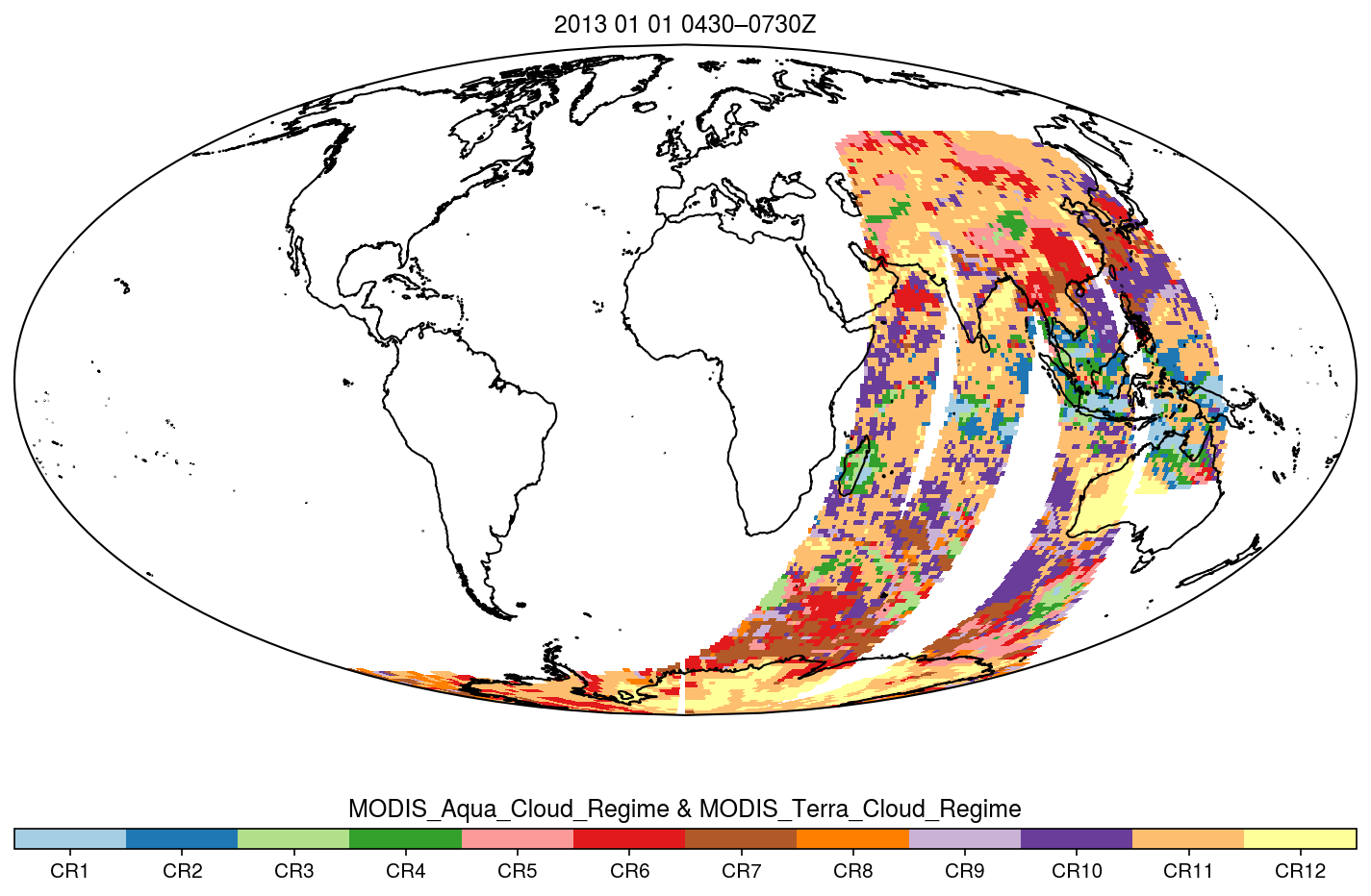
MODIS_CR_Equal_Area_3h
National Aeronautics and Space Administration —
The MODIS Collection 6.1 Equal-Area Three-Hourly Cloud Regime product. This product is a discrete classification of cloud fields at the mesoscale as observed by the... -
Federal
OMPS-N20 NM PCA SO2 Step 1 Total Column 1-Orbit L2 Swath 17x13km
National Aeronautics and Space Administration —
The OMPS-N20 NM PCA SO2 Step1 Total Column 1-Orbit L2 Swath 17x13km collection 1 product contains the retrieved sulfur dioxide (SO2) measured by the Ozone Mapping and... -
Federal
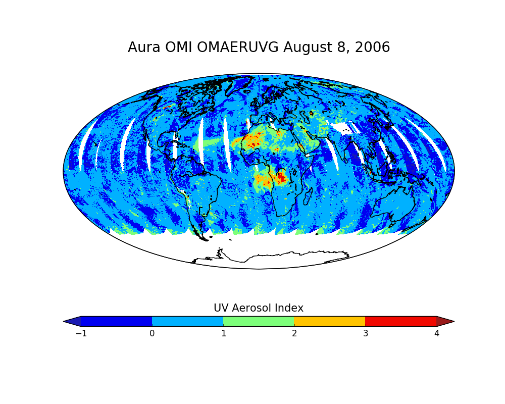
OMI/Aura Near UV Aerosol Optical Depth and Single Scattering Albedo Daily L2 Global Gridded 0.25 degree x 0.25 degree V3 (OMAERUVG) at GES DISC
National Aeronautics and Space Administration —
This Level-2G daily global gridded product OMAERUVG is based on the pixel level OMI Level-2 AERUV product OMAERUV. This Level-2G daily global gridded product OMAERUVG...
.jpg)
42,014 datasets found for "Base Maps"