

4,012 datasets found for "39f텔레carrotDB⊇유흥디비문의ll_"
-
Federal
Risk-Based Prioritization of Organic Chemicals and Locations of Ecological Concern in Sediment From Great Lakes Tributaries
U.S. Environmental Protection Agency —
Data from "Baldwin AK, Corsi SR, Stefaniak OM, Loken LC, Villeneuve DL, Ankley GT, Blackwell BR, Lenaker PL, Nott MA, Mills MA. Risk-Based Prioritization of Organic... -
Federal
Anthropometric Database for Disposable Respirator and Mask Performance
U.S. Environmental Protection Agency —
This dataset comprises craniometric and anthropometric dimensions from over 300 participants collected as part of the FACEFIT and FACEFIT2.0 projects. This data was... -
Federal
BLM Natl 3DEP LiDAR Priorities
Department of the Interior —
BLM 3DEP LIDAR Priority Planning Areas map service for viewing BLM’s participation to the USGS 3DEP (3D Elevation Program) to collaborate to acquire high-resolution... -
Federal
BLM Natl ROW Ten West Link TLine Derived Line
Department of the Interior —
This theme contains polylines of the Ten West Link transmission line with attributes for Name. -
Federal
Figure 4. Upper Soldier Creek Climate Scenario Summary. RCP4.5 scenarios for total phosphorus loads for 2021-2050 time frame as compared to 2014 baseline.
U.S. Environmental Protection Agency —
Figure 4 data set. Upper Soldier Creek Climate Scenario Summary. RCP4.5 scenarios for 2021-2050 time frame as compared to 2014 baseline. Simulations were run with an... -
Federal
LRIR/Nimbus-6 Level 2 Inverted Profiles of Temperature and Ozone V001 (LRIRN6L2IPAT) at GES DISC
National Aeronautics and Space Administration —
LRIRN6L2IPAT is the Nimbus-6 Limb Radiance Inversion Radiometer (LRIR) Level 2 Inverted Profiles of Temperature and Ozone data product. The product contains daily... -
Federal
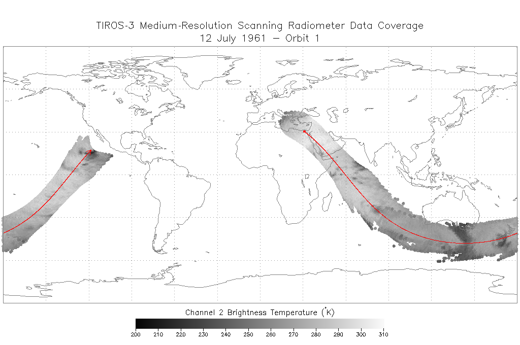
TIROS-3 Medium-Resolution Scanning Radiometer Level 1 Final Meteorological Radiation Data V001 (TIROS3L1FMRT) at GES DISC
National Aeronautics and Space Administration —
TIROS-3 Medium-Resolution Scanning Radiometer Level 1 Final Meteorological Radiation Data (FMRT) product contains radiances expressed in five infrared/visible... -
Federal
BLM Natl WesternUS FIAT Project Planning Areas 2015 Polygon
Department of the Interior —
This data represents a management strategy of the Fire and Invasives Assessment Tool (FIAT). Project Planning Area (PPA) polygons are part of the FIAT Step 2 process.... -
Federal
Recommended Practices for Calibrated Millimeter-Wave Modulated-Signal Measurements
Department of Commerce —
In this paper, we have demonstrated the importance of choosing the correct reference plane for applications such as over-the-air (OTA) modulated-signal measurements... -
Federal
Data for "Frequency-comb spectroscopy on pure quantum states of a single molecular ion"
Department of Commerce —
These data files contain the data for the measured transition frequencies shown in Table I and the traces in Figure 3 of the publication "Frequency-comb spectroscopy... -
Federal
ACT-America: L1 Raw, Uncalibrated In-Situ CO2, CO, and CH4 Mole Fractions from Towers
National Aeronautics and Space Administration —
This dataset provides Level 1 (L1) in situ atmospheric carbon dioxide (CO2), carbon monoxide (CO), and methane (CH4) concentrations as measured on a network of...
4,012 datasets found for "39f텔레carrotDB⊇유흥디비문의ll_"