
-
Federal
Rugosity Derivative Surface used to characterize the complexity of the seafloor around St. John, USVI
National Oceanic and Atmospheric Administration, Department of Commerce —
Rugosity was calculated from the bathymetry surface for each cell using the "Rugosity" function in the Benthic Terrain Modeler toolbox (Jenness 2002, 2004; Wright et... -
Federal
Benthic Habitat of Oahu Derived From IKONOS and Quick Bird Satellite Imagery, 2004-2006
National Oceanic and Atmospheric Administration, Department of Commerce —
This project is a cooperative effort between the National Ocean Service, National Centers for Coastal Ocean Science, Center for Coastal Monitoring and Assessment, the... -
Federal
Slope of the Slope Derivative Surface used to characterize the complexity of the seafloor around St. John, USVI
National Oceanic and Atmospheric Administration, Department of Commerce —
Slope of slope was calculated from the bathymetry surface for each raster cell by applying the ArcGIS Spatial Analyst 'Slope' Tool to a previously created slope... -
Federal
Benthic Habitat of Lanai Derived From IKONOS and Quick Bird Satellite Imagery, 2004-2006
National Oceanic and Atmospheric Administration, Department of Commerce —
This project is a cooperative effort between the National Ocean Service, National Centers for Coastal Ocean Science, Center for Coastal Monitoring and Assessment, the... -
Federal
Benthic Habitats of Kauai Derived From IKONOS and Quick Bird Satellite Imagery, 2004-2006
National Oceanic and Atmospheric Administration, Department of Commerce —
This project is a cooperative effort between the National Ocean Service, National Centers for Coastal Ocean Science, Center for Coastal Monitoring and Assessment, the... -
Federal
LISTEN (Long-term Investigations into Soundscapes, Trends, Ecosystems, and Noise ) 2021-2022: Beaked whale click detections and 3D localizations at GC14_01 & GC14_02
National Oceanic and Atmospheric Administration, Department of Commerce —
This dataset contains 3D localizations of beaked whales at the LISTEN Green Canyon acoustic monitoring site. An array of three High-frequency Acoustic Recording... -
Federal
ONMS_MB02_20230817-20240604_HMD part of ONMS Sound Hybrid Millidecade Spectra
National Oceanic and Atmospheric Administration, Department of Commerce —
To understand natural and anthropogenic sound in the ocean, and to compare underwater soundscapes globally, standard methods of analysis must be applied to passive... -
Federal
ONMS_MB01_20231213-20240616_HMD part of ONMS Sound Hybrid Millidecade Spectra
National Oceanic and Atmospheric Administration, Department of Commerce —
To understand natural and anthropogenic sound in the ocean, and to compare underwater soundscapes globally, standard methods of analysis must be applied to passive... -
Federal
ONMS_MB02_20240401 part of ONMS Sound Raw Passive Acoustic Data
National Oceanic and Atmospheric Administration, Department of Commerce —
This record represents the raw passive acoustic data collected by NOAA's Office of National Marine Sanctuaries (ONMS) Sound Monitoring Program at site MB02 between... -
Federal
Synthesis of Winter In Situ Soil CO2 Flux in pan-Arctic and Boreal Regions, 1989-2017
National Aeronautics and Space Administration —
This dataset provides a synthesis of winter ( September-April) in situ soil CO2 flux measurement data from locations across pan-Arctic and Boreal permafrost regions.... -
Federal
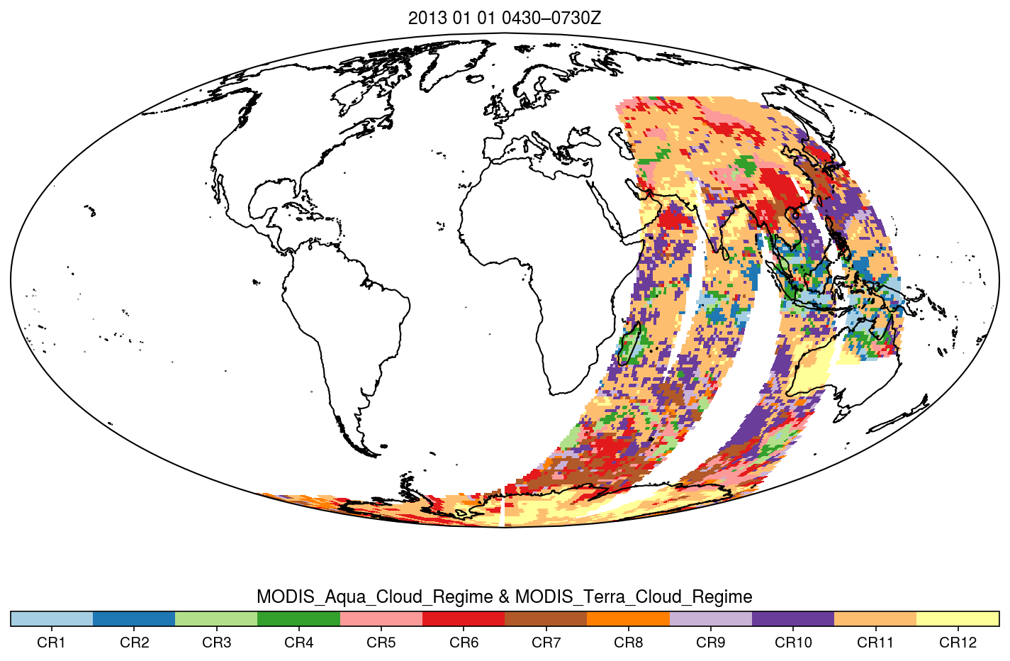
MODIS_CR_Equal_Area_3h
National Aeronautics and Space Administration —
The MODIS Collection 6.1 Equal-Area Three-Hourly Cloud Regime product. This product is a discrete classification of cloud fields at the mesoscale as observed by the... -
Federal
MISR Level 3 Component Global Radiance Product covering a month subset for the UAE region V005
National Aeronautics and Space Administration —
UAEMRMRD_005 is the Multi-angle Imaging SpectroRadiometer (MISR) Level 3 Component Global Radiance Product covering a month subset for the UAE region version 5. It... -
Federal
MISR Level 3 FIRSTLOOK Component Global Radiance Product covering a month V002
National Aeronautics and Space Administration —
This file contains the MISR Level 3 FIRSTLOOK Component Global Radiance Product covering a month.MI3MRDF_002 is the Multi-angle Imaging SpectroRadiometer (MISR) Level... -
Federal
SMEX04 Site Photographs, Arizona, Version 1
National Aeronautics and Space Administration —
Notice to Data Users: The documentation for this data set was provided solely by the Principal Investigator(s) and was not further developed, thoroughly reviewed, or... -
Federal
Sloan Digital Sky Survey DR7 White Dwarf Catalog
National Aeronautics and Space Administration —
This table contains a new catalog of spectroscopically confirmed white dwarf stars from the Sloan Digital Sky Survey (SDSS) Data Release 7 (DR7) spectroscopic... -
Federal
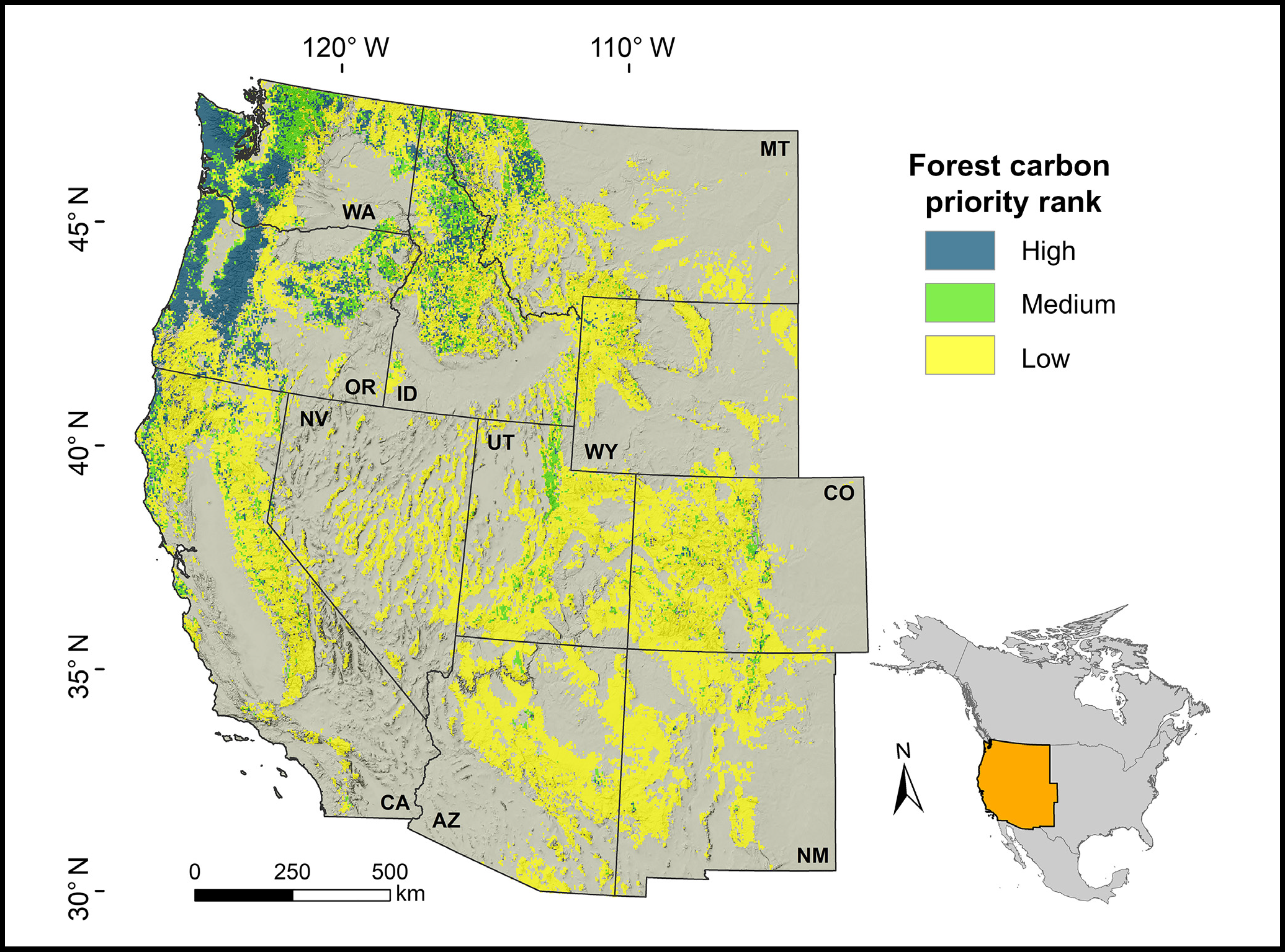
Forest Preservation Ranking and Vertebrate Species Richness, Western USA, 2020-2099
National Aeronautics and Space Administration —
This dataset provides related gridded outputs of future modeled forest carbon sequestration priority and related species richness and habitat suitability for the... -
Federal
Benthic Habitats of Florida Bay, FL 1991-1995 Biotic
National Oceanic and Atmospheric Administration, Department of Commerce —
In the winter of 1991/92 the National Oceanic and Atmospheric Administration's Office for Coastal Management's Coastal Change Analysis Program (C-CAP) and the State... -
Federal
C-CAP Land Cover, Commonwealth of the Northern Mariana Islands (CNMI), Tinian 2006
National Oceanic and Atmospheric Administration, Department of Commerce —
This data set consists of land derived from high resolution imagery and was analyzed according to the Coastal Change Analysis Program (C-CAP) protocol to determine... -
Federal
NOAA-16 AVHRR Atmospherically Corrected Normalized Difference Vegetation Index Daily L3 Global 0.05 Deg. CMG
National Aeronautics and Space Administration —
The Long-Term Data Record (LTDR) produces, validates, and distributes a global land surface climate data record (CDR) that uses both mature and well-tested algorithms... -
Federal
NOAA-14 AVHRR Atmospherically Corrected Normalized Difference Vegetation Index Daily L3 Global 0.05 Deg. CMG
National Aeronautics and Space Administration —
The Long-Term Data Record (LTDR) produces, validates, and distributes a global land surface climate data record (CDR) that uses both mature and well-tested algorithms...

Official websites use .gov
A
.gov website belongs to an official government
organization in the United States.
Secure .gov websites use HTTPS
A
lock (
) or https:// means you’ve safely connected to
the .gov website. Share sensitive information only on official,
secure websites.