
-
Federal
Gazetteer of Planetary Nomenclature: Moon: 1:1 million-scale maps of the Moon
National Aeronautics and Space Administration —
The purpose of the lunar maps is to provide an up-to-date and comprehensive depiction on lunar nomenclature approved by the International Astronomical Union (IAU). -
Federal
Gazetteer of Planetary Nomenclature: Saturnian System: Titan
National Aeronautics and Space Administration —
These images display several of Saturn's moons approved by the International Astronomical Union (IAU). -
Federal
NIST Structured Forms Reference Set of Binary Images (SFRS) - NIST Special Database 2
National Institute of Standards and Technology —
The documents in this database are 12 different tax forms from the IRS 1040 Package X for the year 1988. These include Forms 1040, 2106, 2441, 4562, and 6251 together... -
Federal
Patent Application Full Text Data with Embedded TIFF Images (2001 - Present) (Application Red Book based on WIPO ST.36)
Department of Commerce —
Contains the full text, images/drawings, and complex work units (tables, mathematical expressions, chemical structures, and genetic sequence data) of each patent... -
Federal
2 meter unenhanced GeoTIFF Sidescan-Sonar Mosaic of Virgin Basin - Lake Mead, Nevada (VBASIN_UNGEOG.TIF, geographic)
Department of the Interior —
Lake Mead is a large interstate reservoir located in the Mojave Desert of southeastern Nevada and northwestern Arizona. It was impounded in 1935 by the construction... -
Federal
Images of Fracture Sustainability Test on Stripa Granite
Department of Energy —
Images of the Stripa Granite core before and after the fracture sustainability test. Photos of fracture faces of Stripa Granite core. -
Federal
Multispectral aerial imagery collected during uncrewed aircraft systems (UAS) operations: Plum Island Estuary and Parker River NWR (PIEPR), Massachusetts, November 14, 2017 and March 28, 2019
Department of the Interior —
Low-altitude (80 and 100 meters above ground level) digital images were collected by the USGS Woods Hole Coastal and Marine Science Center (WHCMSC) Aerial Imaging and... -
Federal
Surface Representing the Floor of Lake Mead and the surrounding area: UTM Projection 10m cellsize
Department of the Interior —
Lake Mead is a large interstate reservoir located in the Mojave Desert of southeastern Nevada and northwestern Arizona. It was impounded in 1935 by the construction... -
Federal
Adirondack Inventory & Monitoring (AIM) Network Data Release Volume 1 (2021 - 2023)
Department of the Interior —
This volume's release consists of 42105 media files captured by autonomous wildlife monitoring devices under the project, Adirondack Inventory & Monitoring (AIM)... -
Federal
EX2103: 2021 ROV Shakedown (ROV & Mapping)
National Oceanic and Atmospheric Administration, Department of Commerce —
This Remotely Operated Vehicle (ROV) shakedown expedition aboard NOAA Ship Okeanos Explorer began in Norfolk, Virginia on June 13, 2021 and concluded on June 28, 2021... -
Federal
Gazetteer of Planetary Nomenclature: Venus: 1:10 million-scale Altimetry Quadrangles: Guinevere
National Aeronautics and Space Administration —
This set of maps diplays altimetric radar images of Venus approved by the International Astronomical Union (IAU). -
Federal
Gazetteer of Planetary Nomenclature: Saturnian System: Janus
National Aeronautics and Space Administration —
These images display several of Saturn's moons approved by the International Astronomical Union (IAU). -
Federal
EX2107: Windows to the Deep 2021: Southeast U.S. (ROV and Mapping)
National Oceanic and Atmospheric Administration, Department of Commerce —
The Windows to the Deep 2021: Southeast U.S. ROV and Mapping expedition (EX-21-07) was a combined mapping and remotely operated vehicle (ROV) expedition to the Blake... -
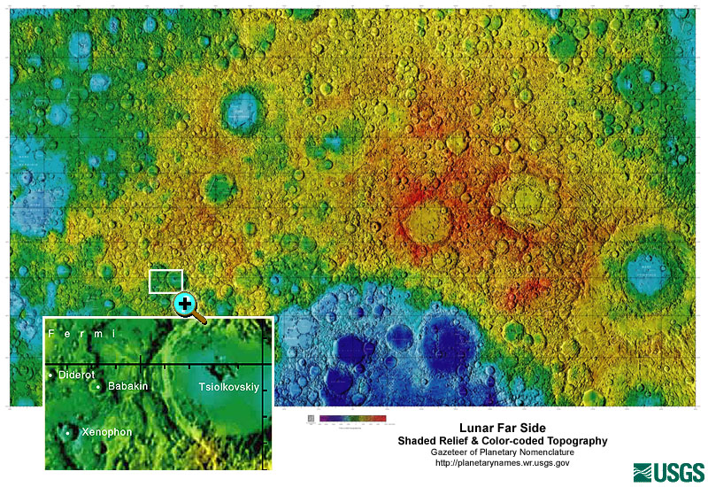
Federal
Gazetteer of Planetary Nomenclature: Moon: 1:10 million-scale Shaded Relief and Color-coded Topography: Far Side
National Aeronautics and Space Administration —
These lunar maps display the four different areas of the moon with color-coded topography in low and high resolution approved by the International Astronomical Union... -
Federal
Gazetteer of Planetary Nomenclature: Saturnian System: Enceladus
National Aeronautics and Space Administration —
These images display several of Saturn's moons approved by the International Astronomical Union (IAU). -
Federal
Gazetteer of Planetary Nomenclature: Jovian System: Thebe
National Aeronautics and Space Administration —
These images display several of Jupiter's moons approved by the International Astronomical Union (IAU). -
Federal
Gazetteer of Planetary Nomenclature: Asteroids: Rheasilvia
National Aeronautics and Space Administration —
These images display asteriods documented and approved by the International Astronomical Union (IAU). -
Federal
Gazetteer of Planetary Nomenclature: Asteroids: Eros
National Aeronautics and Space Administration —
These images display asteriods documented and approved by the International Astronomical Union (IAU). -
Federal
Gazetteer of Planetary Nomenclature: Asteroids: Lutetia Features
National Aeronautics and Space Administration —
These images display asteriods documented and approved by the International Astronomical Union (IAU). -
Federal
EX2104: 2021 North Atlantic Stepping Stones: New England and Corner Rise Seamounts (ROV and Mapping)
National Oceanic and Atmospheric Administration, Department of Commerce —
The 2021 North Atlantic Stepping Stones: New England and Corner Rise Seamounts expedition (EX-21-04) was a combined mapping and remotely operated vehicle (ROV)...

Official websites use .gov
A
.gov website belongs to an official government
organization in the United States.
Secure .gov websites use HTTPS
A
lock (
) or https:// means you’ve safely connected to
the .gov website. Share sensitive information only on official,
secure websites.