

33 datasets found
-
Federal
West Flank Coso FORGE: Geologic Cross-Sections
Department of Energy —
Geologic cross sections from the West Flank FORGE site. Cross Section traces linked in resources. -
Federal
West Flank Coso FORGE: Downhole Lithologic Data
Department of Energy —
x,y,z downhole lithologic logs for the wells in and around the West Flank FORGE site based on a review of cuttings, core, and mud logs. -
Federal
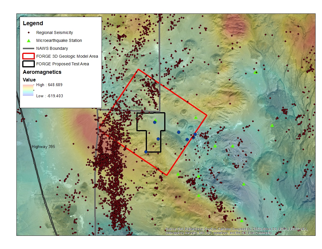
West Flank Coso, CA FORGE Test Area
Department of Energy —
A map with the Coso West Flank FORGE test area outlined, along with regional seismicity, the aeromagnetic data set and the area currently being utilized for the... -
Federal
West Flank Coso FORGE: 33-7 Image Log
Department of Energy —
EMI (Electric Micro Imaging tool, Halliburton) image log in GMI Imager format. GMI Imager is software available from Baker Hughes and is used to open .img files. -
Federal
DEEPEN Data Catalog for Magmatic Geothermal Systems in the United States
Department of Energy —
This data catalog contains information related to the Training Site Analysis for the Geothermica project "DE-risking Exploration of geothermal Plays in magmatic... -
Federal
West Flank Coso FORGE: Seismic Reflection
Department of Energy —
PDFs of seismic reflection profiles 101,110, 111 local to the West Flank FORGE site. 45 line kilometers of seismic reflection data are processed data collected in... -
Federal
West Flank Coso FORGE: 3D Geologic Model
Department of Energy —
This is an x,y,z file of the West Flank FORGE 3D geologic model. Model created in Earthvision by Dynamic Graphic Inc. The model was constructed with a grid spacing of... -
Federal
Envisat Track 349 and Sentinel-1A Track 64 Interferometric Synthetic Aperture Radar Data of Coso Geothermal Field, California, USA, 2004-2016
Department of Energy —
This submission contains tarred pair directories for interferometric synthetic aperture radar (InSAR) data covering Coso Geothermal Field in California, USA.... -
Federal
West Flank Coso, CA Magnetic and Gravity Data
Department of Energy —
Gravity and aeromagnetic data for West Flank FORGE site. -
Federal
West Flank Coso FORGE: Well Photos and Notes
Department of Energy —
Photos and detailed downhole lithology notes for wells CGEH-1 and 74-2 at the West Flank Coso, Ca FORGE location. -
Federal
West Flank Coso FORGE Digital Elevation Model and Geology Shapefiles
Department of Energy —
Geologic ArcGIS data of West Flank Coso, Ca FORGE site from a unpublished map by Rich Whitmarsh. The zip file includes a DEM, hillshade and four shapefiles of the... -
Federal
West Flank Coso FORGE: Magnetotelluric 3D Data
Department of Energy —
This is the 3D version of the MT data for the West Flank Coso FORGE area. The Coso geothermal field has had three Magnetotelluric (MT) datasets collected including... -
Federal
Mineralogical and Lithological Data from Great Basin Geothermal Systems
Department of Energy —
Mineralogical and lithological data from core samples taken at various geothermal wells in the Great Basin: Dixie Valley, Beowawe, Roosevelt, Mammoth, Steamboat...
33 datasets found