

2,641 datasets found
-
Federal
USGS Water Use Data for the Nation - National Water Information System (NWIS) recent views
Department of the Interior —
The U.S. Geological Survey's National Water-Use Information Program is responsible for compiling and disseminating the nation's water-use data. The USGS works in... -
Federal
EnviroAtlas - Cattle Operations by County recent views
U.S. Environmental Protection Agency —
This EnviroAtlas dataset summarizes by county the number of farm operations with cattle and the number of heads they manage. The data come from the Census of... -
Federal
National watershed boundary (HUC12) dataset for the conterminous United States, retrieved 10/26/2020 recent views
Department of the Interior —
This child item provides a snapshot of the watershed boundary dataset which consists of a shapefile with 87,020 12-digit hydrologic unit codes (HUC12) for the... -
Federal
Groundwater depletion in the United States (1900-2008) recent views
Department of the Interior —
A natural consequence of groundwater withdrawals is the removal of water from subsurface storage, but the overall rates and magnitude of groundwater depletion in the... -
Federal
BLM Colorado Grazing Allotments recent views
Department of the Interior —
The purpose of this polygon feature class is to show BLM Colorado Grazing Allotments, which are areas of land designated and managed for grazing of livestock. It may... -
Federal
BLM Natl AIM Riparian and Wetland Indicators Hub recent views
Department of the Interior —
This feature class includes monitoring data collected nationally to understand the status, condition, and trend of resources on BLM lands. Data are collected in... -
University
Aquifers recent views
Earth Data Analysis Center, University of New Mexico —
This map layer contains the shallowest principal aquifers of the conterminous United States, Hawaii, Puerto Rico, and the U.S. Virgin Islands, portrayed as polygons.... -
Federal
GAGES-II: Geospatial Attributes of Gages for Evaluating Streamflow recent views
Department of the Interior —
This dataset, termed "GAGES II", an acronym for Geospatial Attributes of Gages for Evaluating Streamflow, version II, provides geospatial data and classifications for... -
Federal
EnviroAtlas - Selected National Air Toxics Assessment Results by Census Tract - 2014 recent views
U.S. Environmental Protection Agency —
These layers are a selection of the National Air Toxics Assessment (NATA) 2014 estimates of ambient concentrations and health-effect results by 2010 U.S. Census... -
Federal
EnviroAtlas - 303(d) Impairments by 12-digit HUC for the Conterminous United States recent views
U.S. Environmental Protection Agency —
This EnviroAtlas dataset depicts the total length of stream or river flowlines that have impairments submitted to the EPA by states under section 303(d) of the Clean... -
Federal
BLM Natl MLRS Geothermal Leases recent views
Department of the Interior —
This dataset contains geothermal leases cases derived from Legal Land Descriptions (LLD) contained in the US Bureau of Land Management's, BLM, Mineral and Land Record... -
Federal
United States Documented Unplugged Orphaned Oil and Gas Well Dataset recent views
Department of the Interior —
The United States Documented Unplugged Orphaned Oil and Gas Well (DOW) dataset contains 117,672 wells in 27 states. The definition of an orphaned oil or gas well... -
Federal
Air Emissions/IGD: EF_ICIS_AIR recent views
U.S. Environmental Protection Agency —
EF_ICIS_AIR is a subset of facilities from FRS_PROGRAM_FACILITY and associated best-available geospatial coordinates. Facility Registry Service (FRS) data are... -
Federal
BLM Natl WesternUS GRSG ROD Habitat Mgmt Areas August 2022 recent views
Department of the Interior —
This dataset represents the consolidated submissions of GRSG habitat management areas from each individual BLM ARMP & ARMPA/Records of Decision (ROD) and for... -
Federal
Predictive soil property map: Soil pH recent views
Department of the Interior —
These data were compiled to demonstrate new predictive mapping approaches and provide comprehensive gridded 30-meter resolution soil property maps for the Colorado... -
Federal
EnviroAtlas - National Biodiversity Ecosystem Services Metrics by 12-digit HUC for the Conterminous United States recent views
U.S. Environmental Protection Agency —
This EnviroAtlas dataset contains species richness metrics based on habitat models generated by the U.S. Geological Survey (USGS) National Gap Analysis Project (GAP).... -
Federal
BLM Natl NLCS National Monuments National Conservation Areas Polygons recent views
Department of the Interior —
This polygon feature class represents the spatial extent and boundaries of the BLM National Landscape Conservation System (NLCS) National Monuments, National... -
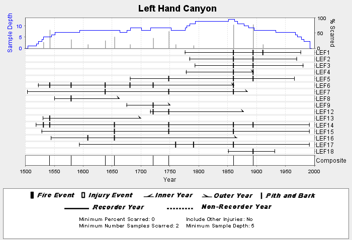
Federal
NOAA/WDS Paleoclimatology - Brown fire data from Left Hand Canyon - IMPD USLEF001 recent views
National Oceanic and Atmospheric Administration, Department of Commerce —
This archived Paleoclimatology Study is available from the NOAA National Centers for Environmental Information (NCEI), under the World Data Service (WDS) for... -
University
New Mexico Federal Lands recent views
Earth Data Analysis Center, University of New Mexico —
This map layer consists of federally owned or administered lands of the United States, Puerto Rico, and the U.S. Virgin Islands. Only areas of 640 acres or more are... -
Federal
Hazardous Waste/IGD: EF_RCRA recent views
U.S. Environmental Protection Agency —
EF_RCRA is a subset of facilities from FRS_PROGRAM_FACILITY and associated best-available geospatial coordinates. Facility Registry Service (FRS) data are refreshed...
2,641 datasets found