
-
Federal
2024 Cartographic Boundary File (SHP), Census Tract for Alaska, 1:500,000
U.S. Census Bureau, Department of Commerce —
The 2024 cartographic boundary shapefiles are simplified representations of selected geographic areas from the U.S. Census Bureau's Master Address File /... -
Federal
Percent Change in Annual Precipitation (Alaska) (Image Service)
Department of Agriculture —
The National Forest Climate Change Maps project was developed to meet the need of National Forest managers for information on projected climate changes at a scale... -
Federal
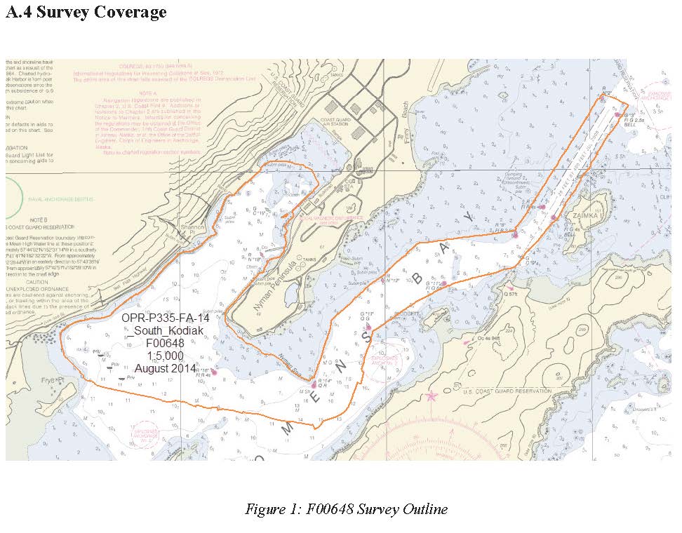
F00648: NOS Hydrographic Survey , 2014-08-18
National Oceanic and Atmospheric Administration, Department of Commerce —
The National Oceanic and Atmospheric Administration (NOAA) has the statutory mandate to collect hydrographic data in support of nautical chart compilation for safe... -
Federal
TIGER/Line Shapefile, Current, State, Alaska, County Subdivision
U.S. Census Bureau, Department of Commerce —
This resource is a member of a series. The TIGER/Line shapefiles and related database files (.dbf) are an extract of selected geographic and cartographic information... -
Federal
BLM Natl AIM Riparian and Wetland Indicators Hub
Department of the Interior —
This feature class includes monitoring data collected nationally to understand the status, condition, and trend of resources on BLM lands. Data are collected in... -
Federal
TIGER/Line Shapefile, 2021, County, Anchorage Municipality, AK, All Roads
U.S. Census Bureau, Department of Commerce —
The TIGER/Line shapefiles and related database files (.dbf) are an extract of selected geographic and cartographic information from the U.S. Census Bureau's Master... -
Federal
2024 Cartographic Boundary File (KML), Block Group for Alaska, 1:500,000
U.S. Census Bureau, Department of Commerce —
The 2024 cartographic boundary KMLs are simplified representations of selected geographic areas from the U.S. Census Bureau's Master Address File / Topologically... -
Federal
2024 Cartographic Boundary File (SHP), County Subdivision for Alaska, 1:500,000
U.S. Census Bureau, Department of Commerce —
The 2024 cartographic boundary shapefiles are simplified representations of selected geographic areas from the U.S. Census Bureau's Master Address File /... -
Federal
Raw Knudsen 320B/R CHIRP Subbottom Profiler - CHIRP Subbottom Profiler Data for the Arctic Ocean ECS Survey
National Oceanic and Atmospheric Administration, Department of Commerce —
Knudsen 320B/R CHIRP Subbottom Profiler - CHIRP Subbottom Profiler data were collected in Raw Knudsen SEG-Y Datagram format. -
Federal
Rapid Assessment of Vegetation Condition after Wildfire Fire (ver. 10.0, January 2025)
Department of the Interior —
The Rapid Assessment of Vegetation Condition after Wildfire (RAVG) program provides assessments of vegetation conditions following large fires on forested lands. Fire... -
Federal
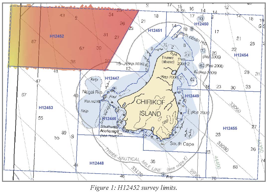
H12452: NOS Hydrographic Survey , Chirikof Island and Vicinity, AK, 2012-08-22
National Oceanic and Atmospheric Administration, Department of Commerce —
The National Oceanic and Atmospheric Administration (NOAA) has the statutory mandate to collect hydrographic data in support of nautical chart compilation for safe... -
Federal
National Land Cover Database (NLCD) Tree Canopy Cover (TCC) Southeast Alaska NGDA
Department of Agriculture —
The USDA Forest Service (USFS) builds two versions of percent tree canopy cover data, in order to serve needs of multiple user communities. These datasets encompass... -
Federal
TIGER/Line Shapefile, 2020, State, Alaska, AK, 118th Congressional District
U.S. Census Bureau, Department of Commerce —
The TIGER/Line shapefiles and related database files (.dbf) are an extract of selected geographic and cartographic information from the U.S. Census Bureau's Master... -
Federal
BLM Natl AIM Terrestrial Species Indicators Public
Department of the Interior —
Species indicator data from AIM Terrestrial datasets TerrADat and LMF. AIM Terrestrial includes monitoring data collected nationally to understand the status,... -
Federal
Kvichak River RISEC Project Resource Reconnaissance and Physical Characterization, Igiugig, AK
Department of Energy —
During the summer and fall of 2011 TerraSond Ltd. (TerraSond) completed a bathymetric survey and hydrokinetic energy assessment of the Kvichak River at Igiugig,... -
Federal
TIGER/Line Shapefile, 2021, County, Kenai Peninsula Borough, AK, All Roads
U.S. Census Bureau, Department of Commerce —
The TIGER/Line shapefiles and related database files (.dbf) are an extract of selected geographic and cartographic information from the U.S. Census Bureau's Master... -
Federal
Terrestrial Condition Assessment (TCA) Alaska Tree Mortality 0 to 5 years (Image Service)
Department of Agriculture —
Direct Download (Raster Data Gateway) Objective: Characterize recent impacts to terrestrial ecosystems due to outbreaks of major invasive, non-native, and native... -
Federal
Raw ODEC Bathy2000 CHIRP Subbottom Profiler - CHIRP High-Resolution Seismic Profile Data for the Chukchi Cap and Arctic Ocean
National Oceanic and Atmospheric Administration, Department of Commerce —
ODEC Bathy2000 CHIRP subbottom profiler - CHIRP high-resolution Seismic Profile data were collected in Raw ODEC Bathy2000 CHIRP dat Datagram Format. -
Federal
Compilation of multi-agency water temperature observations for U.S. streams, 1894-2022
Department of the Interior —
This data release collates stream water temperature observations from across the United States from four data sources: The U.S. Geological Survey's National Water... -
Federal
H13564: NOS Hydrographic Survey , 2022-06-29
National Oceanic and Atmospheric Administration, Department of Commerce —
The National Oceanic and Atmospheric Administration (NOAA) has the statutory mandate to collect hydrographic data in support of nautical chart compilation for safe...

Official websites use .gov
A
.gov website belongs to an official government
organization in the United States.
Secure .gov websites use HTTPS
A
lock (
) or https:// means you’ve safely connected to
the .gov website. Share sensitive information only on official,
secure websites.