
-
Federal
H13677: NOS Hydrographic Survey , 2022-12-04 recent views
National Oceanic and Atmospheric Administration, Department of Commerce —
The National Oceanic and Atmospheric Administration (NOAA) has the statutory mandate to collect hydrographic data in support of nautical chart compilation for safe... -
Federal
H13647: NOS Hydrographic Survey , 2022-08-24 recent views
National Oceanic and Atmospheric Administration, Department of Commerce —
The National Oceanic and Atmospheric Administration (NOAA) has the statutory mandate to collect hydrographic data in support of nautical chart compilation for safe... -
Federal
2022 Cartographic Boundary File (SHP), Current Place for Louisiana, 1:500,000 recent views
U.S. Census Bureau, Department of Commerce —
The 2022 cartographic boundary shapefiles are simplified representations of selected geographic areas from the U.S. Census Bureau's Master Address File /... -
Federal
2022 Cartographic Boundary File (SHP), Current Unified School District for Louisiana, 1:500,000 recent views
U.S. Census Bureau, Department of Commerce —
The 2022 cartographic boundary shapefiles are simplified representations of selected geographic areas from the U.S. Census Bureau's Master Address File /... -
Federal
2022 Cartographic Boundary File (SHP), Current Census Tract for Louisiana, 1:500,000 recent views
U.S. Census Bureau, Department of Commerce —
The 2022 cartographic boundary shapefiles are simplified representations of selected geographic areas from the U.S. Census Bureau's Master Address File /... -
Federal
BLM ES PLSSPoint recent views
Department of the Interior —
These are the corners of the PLSS. This data set contains summary information about the coordinate location and reliability of corner coordinate information. The... -
Federal
BLM ES SurveySystem recent views
Department of the Interior —
A Survey System Description is a named or numbered area of land that can be identified by a type and a designator. The survey system is generally a simultaneous... -
Federal
TIGER/Line Shapefile, 2020, State, Louisiana, Voting Districts recent views
U.S. Census Bureau, Department of Commerce —
The TIGER/Line shapefiles and related database files (.dbf) are an extract of selected geographic and cartographic information from the U.S. Census Bureau's Master... -
Federal
BLM Natl MLRS Land Use Authorization- Leases-Permits-Easements recent views
Department of the Interior —
This dataset contains land use authorization leases, permits and easement cases derived from Legal Land Descriptions (LLD) contained in the US Bureau of Land... -
Federal
H13819: NOS Hydrographic Survey , 2023-12-08 recent views
National Oceanic and Atmospheric Administration, Department of Commerce —
The National Oceanic and Atmospheric Administration (NOAA) has the statutory mandate to collect hydrographic data in support of nautical chart compilation for safe... -
Federal
BLM Natl MLRS Land Use Authorization- Rights of Way ROW recent views
Department of the Interior —
This dataset contains land use authorization- rights-of-way cases derived from Legal Land Descriptions (LLD) contained in the US Bureau of Land Management's, BLM,... -
Federal
2020 Cartographic Boundary File (SHP), Current County Subdivision for Louisiana, 1:500,000 recent views
U.S. Census Bureau, Department of Commerce —
The 2020 cartographic boundary shapefiles are simplified representations of selected geographic areas from the U.S. Census Bureau's Master Address File /... -
Federal
2022 Cartographic Boundary File (SHP), Current State Legislative District-Lower Chamber for Louisiana, 1:500,000 recent views
U.S. Census Bureau, Department of Commerce —
The 2022 cartographic boundary shapefiles are simplified representations of selected geographic areas from the U.S. Census Bureau's Master Address File /... -
Federal
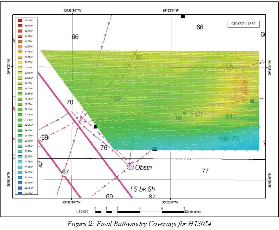
H13054: NOS Hydrographic Survey , 2017-10-30 recent views
National Oceanic and Atmospheric Administration, Department of Commerce —
The National Oceanic and Atmospheric Administration (NOAA) has the statutory mandate to collect hydrographic data in support of nautical chart compilation for safe... -
Federal
TIGER/Line Shapefile, 2021, County, Ouachita Parish, LA, All Roads recent views
U.S. Census Bureau, Department of Commerce —
The TIGER/Line shapefiles and related database files (.dbf) are an extract of selected geographic and cartographic information from the U.S. Census Bureau's Master... -
Federal
BLM ES Administrative Unit Office Points NGDA recent views
Department of the Interior —
This feature-dataset depicts Bureau of Land Management (BLM) office locations. The land areas for higher level administrative units (district and administrative... -
Federal
TIGER/Line Shapefile, 2021, County, St. Martin Parish, LA, All Roads recent views
U.S. Census Bureau, Department of Commerce —
The TIGER/Line shapefiles and related database files (.dbf) are an extract of selected geographic and cartographic information from the U.S. Census Bureau's Master... -
Federal
TIGER/Line Shapefile, 2023, State, Louisiana, Point Landmark recent views
U.S. Census Bureau, Department of Commerce —
The TIGER/Line shapefiles and related database files (.dbf) are an extract of selected geographic and cartographic information from the U.S. Census Bureau's Master... -
Federal
2020 Cartographic Boundary File (SHP), 2020 Public Use Microdata Areas for Louisiana, 1:500,000 recent views
U.S. Census Bureau, Department of Commerce —
The 2020 cartographic boundary shapefiles are simplified representations of selected geographic areas from the U.S. Census Bureau's Master Address File /... -
Federal
2022 Cartographic Boundary File (KML), Current Census Tract for Louisiana, 1:500,000 recent views
U.S. Census Bureau, Department of Commerce —
The 2022 cartographic boundary KMLs are simplified representations of selected geographic areas from the U.S. Census Bureau's Master Address File / Topologically...

Official websites use .gov
A
.gov website belongs to an official government
organization in the United States.
Secure .gov websites use HTTPS
A
lock (
) or https:// means you’ve safely connected to
the .gov website. Share sensitive information only on official,
secure websites.