
-
Federal
SCR/Nimbus-4 Level 1 Calibrated Radiances V001 (SCRN4L1RAD) at GES DISC
National Aeronautics and Space Administration —
SCRN4L1RAD is the Nimbus-4 Selective Chopper Radiometer (SCR) Level 1 Calibrated Radiances data product. The calibrated radiances are measured at 6 channels from 2.3... -
Federal
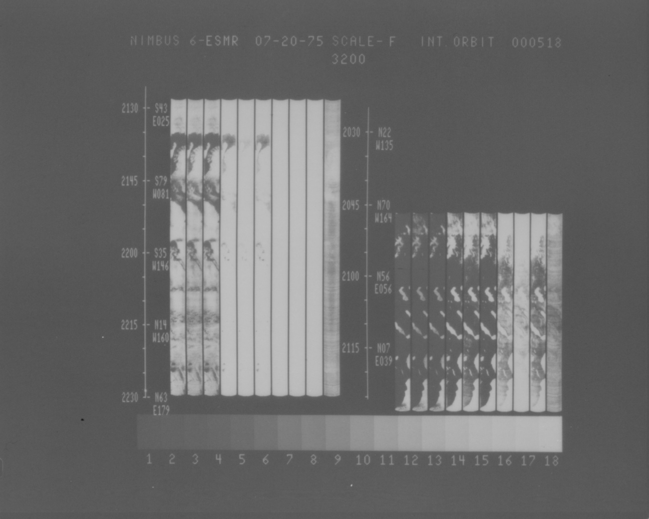
ESMR/Nimbus-6 Images of Brightness Temperature on 70 mm Film V001 (ESMRN6IM) at GES DISC
National Aeronautics and Space Administration —
ESMRN6IM is the Nimbus-6 Electrically Scanning Microwave Radiometer (ESMR) data product containing daily brightness temperature images from 70-mm photofacsimile film... -
Federal
Reactive Transport Modeling of Aquifer Thermal Energy Storage System at Stockton, NJ
Department of Energy —
This is the modeling data (input/output files of TOUGHREACT 4.10) used to simulate the reactive transport processes of the Aquifer Thermal Energy Storage (ATES)... -
Federal
Quality Controlled Lightning Imaging Sensor (LIS) on International Space Station (ISS) Backgrounds V2
National Aeronautics and Space Administration —
The Quality Controlled Lightning Imaging Sensor (LIS) on International Space Station (ISS) Backgrounds dataset was collected by the LIS instrument mounted on the ISS... -
Federal
SCAMS/Nimbus-6 Images of Brightness Temperatures, Water Vapor and Temperature on 70-mm Film V001 (SCAMSN6IM) at GES DISC
National Aeronautics and Space Administration —
The SCAMSN6IM data product consists of images of brightness temperatures, water vapor and temperature on 70 mm film strips from the Nimbus-6 Scanning Microwave... -
Federal
HIRS/Nimbus-6 Images of Brightness Temperature on 70 mm Film V001 (HIRSN6IM) at GES DISC
National Aeronautics and Space Administration —
The HIRSN6IM data product consists of images of brightness temperatures on 70 mm film strips from the Nimbus-6 High Resolution Infrared Radiation Sounder. Each... -
Federal
MRIR/Nimbus-3 Level 1 Meteorological Radiation Data V001 (MRIRN3L1) at GES DISC
National Aeronautics and Space Administration —
MRIRN3L1 is the Nimbus-3 Medium-Resolution Infrared Radiometer (MRIR) Level 1 Meteorological Radiance Data product and contain radiances expressed as equivalent... -
Federal
SIRS/Nimbus-3 Level 1 Radiance Data V001 (SIRSN3L1) at GES DISC
National Aeronautics and Space Administration —
SIRSN3L1 is the Nimbus-3 Satellite Infrared Spectrometer (SIRS) Level 1 Radiance Data product. SIRS measured infrared radiation (11 to 36 micrometers) emitted from... -
Federal
Combined ASTER and MODIS Emissivity database over Land (CAMEL) Uncertainty Monthly Global 0.05Deg V001 NGDA
National Aeronautics and Space Administration —
The NASA Making Earth System Data Records for Use in Research Environments (MEaSUREs) (https://earthdata.nasa.gov/community/community-data-system-programs/measures-... -
Federal
Combined ASTER and MODIS Emissivity database over Land (CAMEL) Emissivity Monthly Global 0.05Deg V001 NGDA
National Aeronautics and Space Administration —
The NASA Making Earth System Data Records for Use in Research Environments (MEaSUREs) (https://earthdata.nasa.gov/community/community-data-system-programs/measures-... -
Federal
Active Management of Integrated Geothermal-CO2 Storage Reservoirs in Sedimentary Formations
Department of Energy —
The purpose of phase 1 is to determine the feasibility of integrating geologic CO2 storage (GCS) with geothermal energy production. Phase 1 includes reservoir... -
Federal
Active Management of Integrated Geothermal-CO2 Storage Reservoirs in Sedimentary Formations
Department of Energy —
Active Management of Integrated Geothermal-CO2 Storage Reservoirs in Sedimentary Formations: An Approach to Improve Energy Recovery and Mitigate Risk : FY1 Final... -
Federal
Lightning Imaging Sensor (LIS) on TRMM Backgrounds V4
National Aeronautics and Space Administration —
The Lightning Imaging Sensor (LIS) Backgrounds was collected by the LIS instrument on the Tropical Rainfall Measuring Mission (TRMM) satellite used to detect the... -
Federal
SAFARI 2000 ER-2 Color-IR Aerial Photography, Dry Season 2000
National Aeronautics and Space Administration —
Aerial photography from the NASA ER-2 high-altitude aircraft was collected to provide detailed and spatially extensive documentation over parts of the SAFARI study... -
Federal
ITPR/Nimbus-5 Level 1 Calibrated Radiances V001 (ITPRN5L1) at GES DISC
National Aeronautics and Space Administration —
ITPRN5L1 is the Nimbus-5 Infrared Temperature Profile Radiometer (ITPR) Level-1 Calibrated Radiances data product which contains radiances at 7 infrared spectral... -
Federal
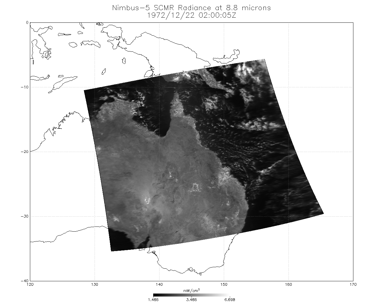
SCMR/Nimbus-5 Level 1 Calibrated and Geolocated Radiances V001 (SCMRN5L1RAD) at GES DISC
National Aeronautics and Space Administration —
SCMRN5L1RAD is the Nimbus-5 Surface Composition Mapping Radiometer (SCMR) Level 1 Calibrated and Geolocated Radiances data product. SCMR measured (1) terrestrial... -
Federal
Active Management of Integrated Geothermal-CO2 Storage Reservoirs in Sedimentary Formations
Department of Energy —
Active Management of Integrated Geothermal-CO2 Storage Reservoirs in Sedimentary Formations: An Approach to Improve Energy Recovery and Mitigate Risk : FY1 Final... -
Federal
Active Management of Integrated Geothermal-CO2 Storage Reservoirs in Sedimentary Formations
Department of Energy —
Active Management of Integrated Geothermal-CO2 Storage Reservoirs in Sedimentary Formations: An Approach to Improve Energy Recovery and Mitigate Risk: FY1 Final... -
Federal
Model output associated with "Inter-comparison of Atmospheric Trace Gas Dispersion Models: Barnett Shale Case Study", Atmospheric Chemistry and Physics, 2019.
National Institute of Standards and Technology —
Please refer to the publication, particularly the information in the Supplementary Information, for details on the model configuration.Footprint files:Footprints... -
Federal
CAMEX-4 MOBILE X-BAND POLARIMETRIC WEATHER RADAR V1
National Aeronautics and Space Administration —
The CAMEX-4 Mobile X-Band Polarimetric Weather Radar dataset was collected by the Mobile X-band Polarimetric Weather Radar on Wheels (X-POW), which is a Doppler...

Official websites use .gov
A
.gov website belongs to an official government
organization in the United States.
Secure .gov websites use HTTPS
A
lock (
) or https:// means you’ve safely connected to
the .gov website. Share sensitive information only on official,
secure websites.