
-
Federal
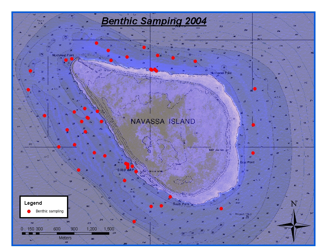
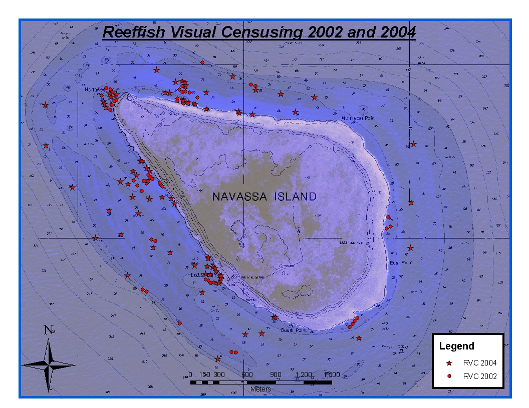
CRCP-Navassa reef assessment recent views
National Oceanic and Atmospheric Administration, Department of Commerce —
Episodic cruises ( every 2 years) were conducted to perform assessments of Navassa Island coral reef resources including reeffish visual census, benthic reef... -
Federal
Cetacean visual observations using line-transect survey methods onboard the NOAA Ship Gordon Gunter (GU) in the Gulf of Mexico (survey GU0402) from 2004-04-15 to 2004-06-10. (NCEI Accession 0284773) recent views
National Oceanic and Atmospheric Administration, Department of Commerce —
The U.S. National Marine Fisheries Service (NMFS) is required to prepare an annual Stock Assessment Report (SAR) for each marine mammal stock to update abundance,... -
Federal
Depth (Standard Deviation) Layer used to identify, delineate and classify moderate-depth benthic habitats around St. John, USVI recent views
National Oceanic and Atmospheric Administration, Department of Commerce —
Standard deviation of depth was calculated from the bathymetry surface for each cell using the ArcGIS Spatial Analyst Focal Statistics "STD" parameter. Standard... -
Federal
Curvature Derivative Surface used to characterize the complexity of the seafloor around St. John, USVI recent views
National Oceanic and Atmospheric Administration, Department of Commerce —
Curvature was calculated from the bathymetry surface for each raster cell using the ArcGIS 3D Analyst "Curvature" Tool. Curvature describes the rate of change of... -
Federal
Backscatter Mosaic used to identify, delineate and classify moderate-depth benthic habitats around St. John, USVI recent views
National Oceanic and Atmospheric Administration, Department of Commerce —
This image represents a 2x2 meter resolution backscatter mosaic of the moderate-depth portion of the NPS's Virgin Islands Coral Reef National Monument, south of St.... -
Federal
NOAA Office for Coastal Management Benthic Habitat Data, Catlett and Goodwin Islands on the York River in Chesapeake Bay, VA, 2002-2004 (NCEI Accession 0090253) recent views
National Oceanic and Atmospheric Administration, Department of Commerce —
These data are a collection of benthic habitat data from studies conducted in the Catlett and Goodwin Islands on the York River in Chesapeake Bay, Virginia in GIS... -
Federal
Water depth and acoustic backscatter data collected from NOAA Ship Nancy Foster in Caribbean Sea from 2010-03-18 to 2010-04-06 (NCEI Accession 0131854) recent views
National Oceanic and Atmospheric Administration, Department of Commerce —
The Center for Coastal Monitoring and Assessment (CCMA) completed its seventh year of an ongoing scientific research mission on board NOAA Ship Nancy Foster. The... -
Federal
Continuous bottom temperature measurements in strategic areas of the Florida Reef Tract recent views
National Oceanic and Atmospheric Administration, Department of Commerce —
This ongoing project began in 1988. A total of 38 subsurface recording thermographs have been deployed in the Florida Keys National Marine Sanctuary (FKNMS) and at... -
Federal
C-CAP Land Cover Change, Commonwealth of the Northern Mariana Islands (CNMI), Farallon de Pajaros, 2004 - 2016 recent views
National Oceanic and Atmospheric Administration, Department of Commerce —
This data set contains the 2004 and 2016 classifications of Farallon de Pajaros, CNMI and can be used to analyze change. This data set utilized 2 full WorldView2 and... -
Federal
C-CAP Land Cover Change, Commonwealth of the Northern Mariana Islands (CNMI), Asuncion Island, 2004 - 2016 recent views
National Oceanic and Atmospheric Administration, Department of Commerce —
This data set contains the 2004 and 2016 classifications of Asuncion, CNMI and can be used to analyze change. This data set utilized 2 full WorldView2 and Quickbird... -
Federal
NOAA TIFF Image - 1m Multibeam Bathymetry, US Virgin Islands - St. John Shelf - Project NF-10-03 - (2010), UTM 20N NAD83 recent views
National Oceanic and Atmospheric Administration, Department of Commerce —
This dataset contains a GeoTIFF with 1x1 meter cell size representing the bathymetry of St. John Shelf, a selected portion of seafloor south of St. John, USVI,... -
Federal
NOAA TIFF Image - 8m Multibeam Bathymetry, US Virgin Islands - St. John Shelf - Project NF-10-03 - (2010), UTM 20N NAD83 recent views
National Oceanic and Atmospheric Administration, Department of Commerce —
This dataset contains a GeoTIFF with 8x8 meter cell size representing the bathymetry of a sharply sloping swath of the St. John Shelf, a selected portion of seafloor... -
Federal
NOAA Transet Lines Shapefile- Benthic Habitat Classifications from Minibat ROV Underwater Video, US Virgin Islands, Project NF-04-06, 2004, UTM 20N WGS84 recent views
National Oceanic and Atmospheric Administration, Department of Commerce —
This dataset contains a line shapefile showing the trackline of various Remotely Operated Vehicle (ROV) underwater video transects in the US Virgin Islands.NOAA's... -
Federal
NOAA TIFF Image - 2m Multibeam Bathymetry, US Virgin Islands - Vieques Island - Project NF-09-01 - (2009), UTM 20N NAD83 recent views
National Oceanic and Atmospheric Administration, Department of Commerce —
This dataset contains a unified ESRI Geotiff with 2x2 meter cell size representing the bathymetry of a selected portion of seafloor southwest of Vieques Island,... -
Federal
NOAA ESRI Geotiff- 1m Bathymetry of St. John (South Shore - Area 1), US Virgin Islands, 2004, UTM 20 WGS84 recent views
National Oceanic and Atmospheric Administration, Department of Commerce —
This dataset contains an ESRI Geotiff with 1 meter cell size representing the bathymetry of the south shore of St. John, US Virgin Islands. Due to the large file size... -
Federal
NOAA TIFF Image - 1m Multibeam Bathymetry, US Virgin Islands - Virgin Passage - Project NF-10-03 - (2010), UTM 20N NAD83 recent views
National Oceanic and Atmospheric Administration, Department of Commerce —
This dataset contains a GeoTIFF with 1x1 meter cell size representing the bathymetry of a portion of the Virgin Passage, a selected area of seafloor southwest of St.... -
Federal
NOAA Point Shapefile- Benthic Habitat Classifications from Minibat ROV Underwater Video, US Virgin Islands, Project NF-04-06, 2004, UTM 20N WGS84 recent views
National Oceanic and Atmospheric Administration, Department of Commerce —
This dataset contains a point shapefile with benthic habitat classifications of vertical relief, geomorphological structure, substrate, and biological cover for... -
Federal
NOAA ESRI Geotiff- 1m Bathymetry of St. Croix (Buck Island), US Virgin Islands, 2004, UTM 20 WGS84 recent views
National Oceanic and Atmospheric Administration, Department of Commerce —
This dataset contains an ESRI Geotiff with 1 meter cell size representing the bathymetry of the north shore of Buck Island St. Croix, US Virgin Islands.NOAA's... -
Federal
NOAA TIFF Image - 1m Multibeam Bathymetry, US Virgin Islands - Vieques Island (El Seco) - Project NF-09-01 - (2009), UTM 20N NAD83 recent views
National Oceanic and Atmospheric Administration, Department of Commerce —
This dataset contains a unified ESRI Geotiff with 1x1 meter cell size representing the bathymetry of El Seco, a selected portion of seafloor east of Vieques Island,... -
Federal
2004 Benthic Grab Data for Catlett and Goodwin Islands on the York River in Chesapeake Bay, Virginia (Ches_2004benthos) recent views
National Oceanic and Atmospheric Administration, Department of Commerce —
This data set represents the benthic community information gathered from grab sampling in 2004 (12 stations). In Fall/Winter 2002, researchers from the Virginia...

Official websites use .gov
A
.gov website belongs to an official government
organization in the United States.
Secure .gov websites use HTTPS
A
lock (
) or https:// means you’ve safely connected to
the .gov website. Share sensitive information only on official,
secure websites.