
-
Federal
Wind Turbine Structure Setbacks: Ordinances (2022) and Extrapolated Trends, 115 Hub Height 170 Rotor Diameter
Department of Energy —
This dataset represents wind energy setback requirements from structures based on existing county ordinances as of April 2022. A setback requirement is a minimum... -
Federal
NOAA/WDS Paleoclimatology - Heyerdahl fire data from Corona Road - IMPD USCOR001
National Oceanic and Atmospheric Administration, Department of Commerce —
This archived Paleoclimatology Study is available from the NOAA National Centers for Environmental Information (NCEI), under the World Data Service (WDS) for... -
Federal
BOREAS RSS-08 Snow Maps Derived from Landsat TM Imagery
National Aeronautics and Space Administration —
The BOREAS RSS-08 team utilized Landsat TM images to perform mapping of snow extent over the SSA. This data set consists of two Landsat TM images which were used to... -
Federal
NOAA/WDS Paleoclimatology - Heyerdahl fire data from Poverty Flat - IMPD USPOV001
National Oceanic and Atmospheric Administration, Department of Commerce —
This archived Paleoclimatology Study is available from the NOAA National Centers for Environmental Information (NCEI), under the World Data Service (WDS) for... -
Federal
NOAA/WDS Paleoclimatology - Brown fire data from O'Neill Pass - IMPD USONP001
National Oceanic and Atmospheric Administration, Department of Commerce —
This archived Paleoclimatology Study is available from the NOAA National Centers for Environmental Information (NCEI), under the World Data Service (WDS) for... -
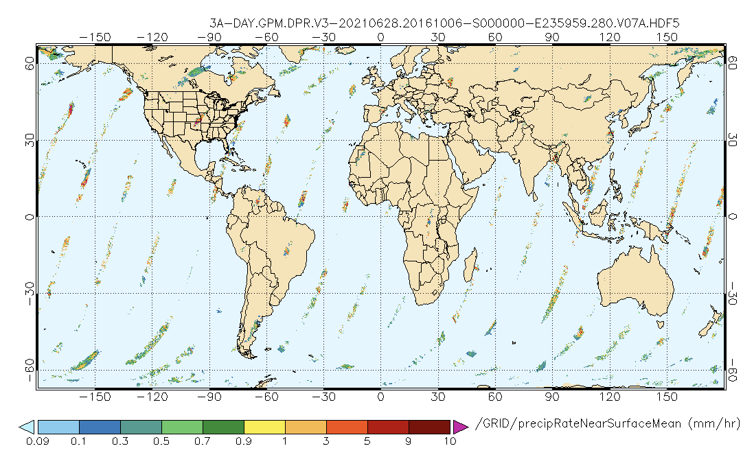
Federal
GPM DPR Precipitation Profile 1 Day 0.25 degree x 0.25 degree V07 (GPM_3DPRD) at GES DISC
National Aeronautics and Space Administration —
Version 07 is the current version of the data set. Older versions will no longer be available and have been superseded by Version 07.. The precipitation estimates in... -
Federal
SAFARI 2000 Surface Atmospheric Radiative Transfer (SMART), Dry Season 2000
National Aeronautics and Space Administration —
Surface-sensing Measurements for Radiative Transfer (SMART) and Chemical, Optical, and Microphysical Measurements of In-situ Troposphere (COMMIT) consist of a suite... -
Federal
GPM IMERG Early Precipitation L3 Half Hourly 0.1 degree x 0.1 degree V07 (GPM_3IMERGHHE) at GES DISC
National Aeronautics and Space Administration —
Version 07B is the current version of the IMERG data sets. Older versions will no longer be available and have been superseded by Version 07.The Integrated Multi-... -
Federal
BASIN TCP Stable Isotope Composition of CO2 in Terrestrial Ecosystems
National Aeronautics and Space Administration —
This data set reports stable isotope ratio data of CO2 (13C/12C and 18O/16O) associated with photosynthetic and respiratory exchanges across the biosphere-atmosphere... -
Federal
Eddy Corr. Surface Flux: UK (FIFE)
National Aeronautics and Space Administration —
Surface flux measurements were made at selected sites within the FIFE study area. Each surface flux station was capable of measuring the fluxes of net radiation,... -
Federal
High Resolution Empirical Tide Prediction Software Version 14
National Aeronautics and Space Administration —
This dataset provides sea surface height and ocean surface currents associated with the predictable astronomical tide at the M2, S2, N2, K1, and O1 frequencies. The... -
Federal
NOAA/WDS Paleoclimatology - Veblen fire data from MallÃn Blest - IMPD ARBLE001
National Oceanic and Atmospheric Administration, Department of Commerce —
This archived Paleoclimatology Study is available from the NOAA National Centers for Environmental Information (NCEI), under the World Data Service (WDS) for... -
Federal
LBA Regional Mean Climatology, 0.5-Deg, 1930-1960, V. 2.1 (Cramer and Leemans)
National Aeronautics and Space Administration —
This data set is a subset of Cramer and Leemans' (2001) global database of mean monthly climatology, which contains monthly averages of mean temperature, temperature... -
Federal
Soil Organic Carbon Stock Estimates with Uncertainty across Latin America
National Aeronautics and Space Administration —
This dataset provides 5 x 5 km gridded estimates of soil organic carbon (SOC) across Latin America that were derived from existing point soil characterization data... -
Federal
ESMR/Nimbus-5 Images of Brightness Temperature on 70 mm Film V001 (ESMRN5IM) at GES DISC
National Aeronautics and Space Administration —
ESMRN5IM is the Nimbus-5 Electrically Scanning Microwave Radiometer (ESMR) data product containing daily brightness temperature images from 70-mm photofacsimile film... -
Federal
Global Distribution of Plant-Extractable Water Capacity of Soil (Dunne)
National Aeronautics and Space Administration —
Plant-extractable water capacity of soil is the amount of water that can be extracted from the soil to fulfill evapotranspiration demands. It is often assumed to be... -
Federal
Carbon Monitoring System Carbon Flux Total Prior L4 V3 (CMSFluxTotalPrior)
National Aeronautics and Space Administration —
This dataset provides the Prior for Total Carbon Flux.The NASA Carbon Monitoring System (CMS) is designed to make significant contributions in characterizing,... -
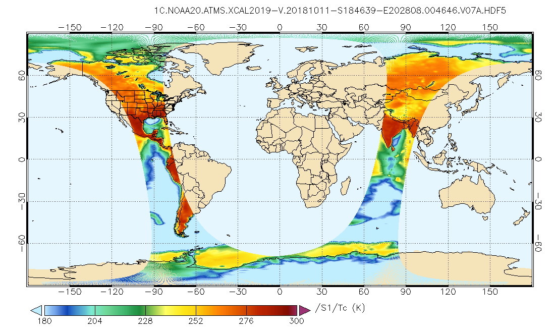
Federal
GPM ATMS on NOAA-20 Common Calibrated Brightness Temperatures L1C 1.5 hours 17 km V07 (GPM_1CNOAA20ATMS) at GES DISC
National Aeronautics and Space Administration —
Version 07 is the current version of the data set. Older versions will no longer be available and have been superseded by Version 07.1CATMS contains common calibrated... -
Federal
LBA-ECO CD-02 Leaf Water Potential, Forest and Pasture Sites, Para, Brazil: 2000-2001
National Aeronautics and Space Administration —
Data are reported for leaf water potential of leaves of seven species of trees and lianas from the primary forest at the km 67 Tower Site, Tapajos National Forest,... -
Federal
SAFARI 2000 Global Historical Climatology Network, V. 1, 1874-1990
National Aeronautics and Space Administration —
This data set consists of a southern African subset of the Global Historical Climatology Network (GHCN) Version 1 database. All stations with the following bounding...

Official websites use .gov
A
.gov website belongs to an official government
organization in the United States.
Secure .gov websites use HTTPS
A
lock (
) or https:// means you’ve safely connected to
the .gov website. Share sensitive information only on official,
secure websites.