
-
Federal
Characterization data on the effects of micro-computed tomography-based x-ray radiation on vinyl nitrile foam
Department of Commerce —
This dataset contains information from investigating the effects of micro-computed tomographic imaging irradiation on vinyl nitrile foam and code for a finite element... -
Federal
Global Population Count Grid Time Series Estimates
National Aeronautics and Space Administration —
The Global Population Count Grid Time Series Estimates provide a back-cast time series of population grids based on the year 2000 population grid from SEDAC's Global... -
Federal
2018 Environmental Performance Index (EPI)
National Aeronautics and Space Administration —
The 2018 Environmental Performance Index (EPI) ranks 180 countries on 24 performance indicators in the following 10 issue categories: air quality, water and... -
Federal
JPL TELLUS GRACE Level-3 Monthly Land Water-Equivalent-Thickness Surface Mass Anomaly Release 6.0 version 04 in netCDF/ASCII/GeoTIFF Formats
National Aeronautics and Space Administration —
The monthly land mass grids contain water mass anomalies given as equivalent water thickness derived from GRACE & GRACE-FO time-variable gravity observations... -
Federal
Process-structure-properties investigations for laser powder bed fused IN718 in the as-built condition
National Institute of Standards and Technology —
This data repository provides a central location for a body of work using one build of nickel-based alloy 718 (IN718) material and resulted in three different... -
Federal
JPL TELLUS GRACE Level-3 Monthly Land Water-Equivalent-Thickness Surface Mass Anomaly Release 6.0 version 04
National Aeronautics and Space Administration —
The monthly land mass grids contain water mass anomalies given as equivalent water thickness derived from GRACE & GRACE-FO time-variable gravity observations... -
Federal
Lacassine National Wildlife Refuge Land Status Map
Department of the Interior —
Land status map of Lacassine National Wildlife Refuge -
Federal
Simulations of Brady's-Type Fault Undergoing CO2 Push-Pull: Pressure-Transient and Sensitivity Analysis
Department of Energy —
Input and output files used for fault characterization through numerical simulation using iTOUGH2. The synthetic data for the push period are generated by running a... -
Federal
SWOT Level 2 Lake Single-Pass Vector Unassigned Data Product, Version 2.0
National Aeronautics and Space Administration —
The SWOT Level 2 Lake Single-Pass Vector Unassigned Data Product from the Surface Water Ocean Topography (SWOT) mission provides water surface elevation, area,... -
Federal
OCO-3 Level 2 geolocated XCO2 retrieval results and algorithm diagnostic information, Forward Processing V11 (OCO3_L2_Diagnostic) at GES DISC
National Aeronautics and Space Administration —
Version 11 is the current version of the data set. Older versions will no longer be available and are superseded by Version 11. The Orbiting Carbon Observatory -3... -
Federal
ASTER L1A Reconstructed Unprocessed Instrument Data V004
National Aeronautics and Space Administration —
The Advanced Spaceborne Thermal Emission and Reflection Radiometer (ASTER) Level 1A (AST_L1A) contains reconstructed, instrument digital numbers (DNs) derived from... -
Federal
NASA-SSH Along-Track Sea Surface Height from Standardized Reference Missions Version 1
National Aeronautics and Space Administration —
The NASA-SSH Along-Track Sea Surface Height from Standardized Reference Missions Version 1 dataset produced by NASA provide observations of sea surface height, or sea... -
Federal
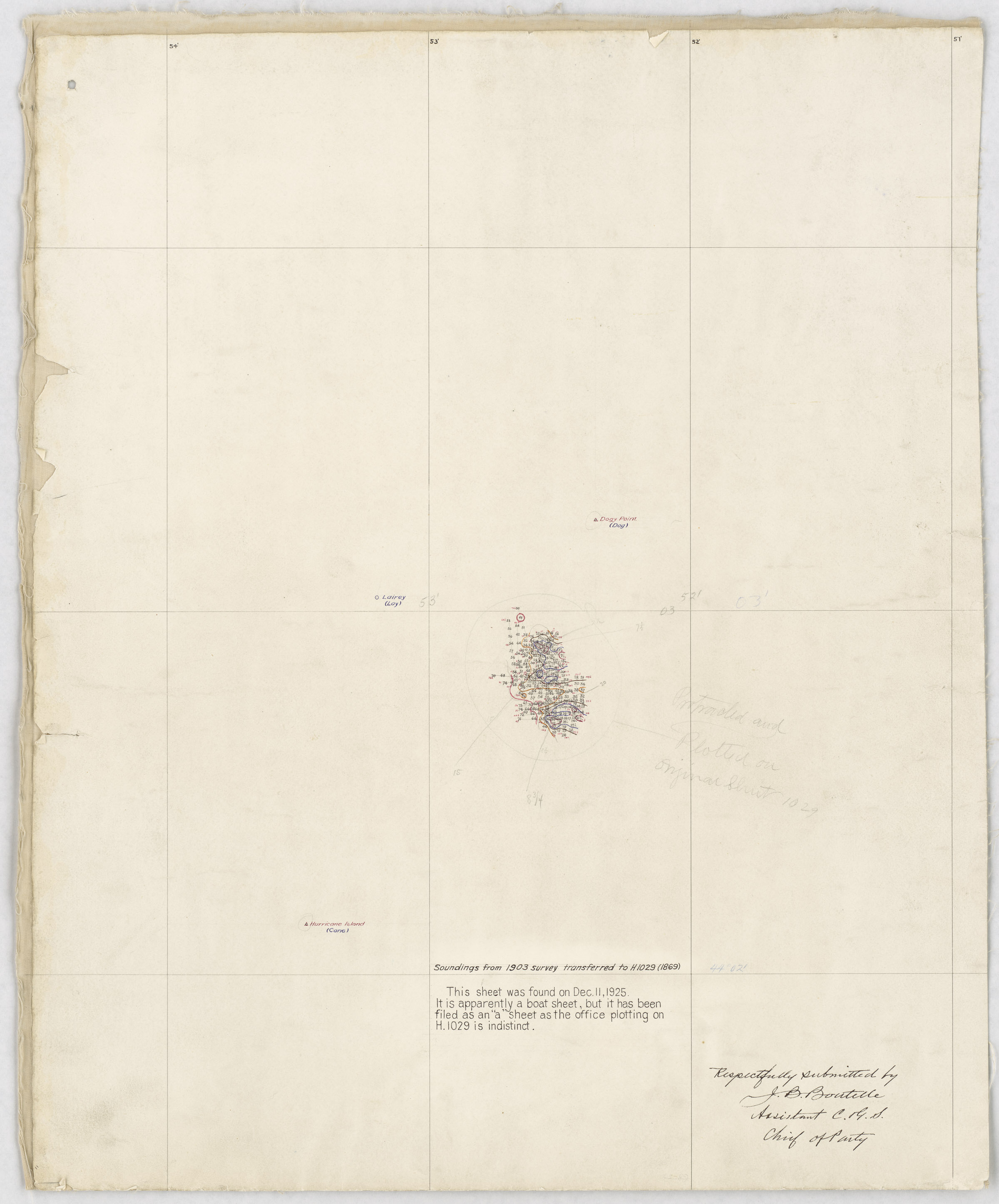
H01029: NOS Hydrographic Survey , 1903-12-31
National Oceanic and Atmospheric Administration, Department of Commerce —
The National Oceanic and Atmospheric Administration (NOAA) has the statutory mandate to collect hydrographic data in support of nautical chart compilation for safe... -
Federal
ABoVE: Passive Microwave-derived Annual Snowpack Main Melt Onset Date Maps, 1988-2023
National Aeronautics and Space Administration —
This dataset provides the annual date of snowpack seasonal beginning melt (i.e., main melt onset date, MMOD) across northwest Canada, Alaska, US, and parts of far... -
Federal
F00708: NOS Hydrographic Survey , 2017-10-06
National Oceanic and Atmospheric Administration, Department of Commerce —
The National Oceanic and Atmospheric Administration (NOAA) has the statutory mandate to collect hydrographic data in support of nautical chart compilation for safe... -
Federal
F00729: NOS Hydrographic Survey , 2018-09-28
National Oceanic and Atmospheric Administration, Department of Commerce —
The National Oceanic and Atmospheric Administration (NOAA) has the statutory mandate to collect hydrographic data in support of nautical chart compilation for safe... -
Federal
OCO-3 Level 2 CO2 prior based on CO2 monthly flask record, global meteorology, and age of air, Forward Processing V11 (OCO3_L2_CO2Prior) at GES DISC
National Aeronautics and Space Administration —
Version 11 is the current version of the data set. Older versions will no longer be available and are superseded by Version 11. The Orbiting Carbon Observatory -3... -
Federal
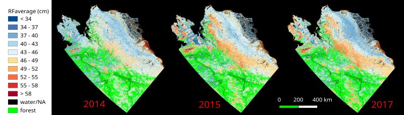
ABoVE: Upscaled Active Layer Thickness in Northern Alaska, 2014-2017
National Aeronautics and Space Administration —
The dataset consists of maps of estimated Active Layer Thickness (ALT) at 30-m resolution throughout the northern half of Alaska for the years 2014, 2015, and 2017.... -
Federal
Global One-Eighth Degree Population Base Year and Projection Grids Based on the Shared Socioeconomic Pathways, Revision 01
National Aeronautics and Space Administration —
The Global One-Eighth Degree Population Base Year and Projection Grids Based on the Shared Socioeconomic Pathways, Revision 01, data set consists of global urban,... -
Federal
Altimeter Corrected Elevations, Version 2 (ACE2)
National Aeronautics and Space Administration —
The Altimeter Corrected Elevations, Version 2 (ACE2) data set, is the Global Digital Elevation Model (GDEM) created by using multi-mission Satellite Radar Altimetry...

Official websites use .gov
A
.gov website belongs to an official government
organization in the United States.
Secure .gov websites use HTTPS
A
lock (
) or https:// means you’ve safely connected to
the .gov website. Share sensitive information only on official,
secure websites.