
-
Federal
Alaska's Changing YK Delta: Knowledge Exchange between Elders and Geoscientists, 2018
National Aeronautics and Space Administration —
This dataset provides a booklet documenting the discussions and outcomes from a knowledge-exchange meeting with Yup'ik elders from the Yukon-Kuskokwim Delta (YKD),... -
Federal
Maps of Vegetation, NDVI, Snow and Thaw Depths: North Slope, Alaska and NWT, Canada
National Aeronautics and Space Administration —
This dataset includes vegetation cover maps, Normalized Difference Vegetation Index (NDVI) maps, snow depth and thaw depth data that were obtained as part of a... -
State
Mule Deer Migration Corridors - Verdi-Truckee - 2009-2010, 2012-2017 [ds2915]
State of California —
The project leads for the collection of this data were Sara Holm with California Department of Fish and Wildlife and Mike Cox with Nevada Department of Wildlife. Carl... -
Federal
EnviroAtlas - Probabilistic Estimates of the Distribution of Near-surface (within 1m) Permafrost in Alaska
U.S. Environmental Protection Agency —
This dataset was created by USGS and is being hosted by US EPA to support research and online mapping activities related to EnviroAtlas. EnviroAtlas... -
Federal
Reynolds Creek Experimental Watershed, Idaho (Snow)
Department of Agriculture —
Snow is the dominant form of precipitation in the Reynolds Creek Experimental Watershed (RCEW). Seven snow course sites were established in 1961, and one additional... -
Federal
BOREAS HYD-05 Bear Trap Creek and Namekus Lake Winter Surface Flux Data
National Aeronautics and Space Administration —
The BOREAS HYD-05 team collected tower flux, surface meteorological, and surface temperature data on a frozen lake (Namekus Lake) and in a mature jack pine forest in... -
Federal
BOREAS HYD-03 Snow Depth Data: 1996
National Aeronautics and Space Administration —
The BOREAS HYD-03 team collected several data sets related to the hydrology of forested areas. This data set contains measurements of snow depth, snow density in 3-cm... -
Federal
BOREAS/SRC AMS Suite A Surface Meteorological and Radiation Data: 1996
National Aeronautics and Space Administration —
The Saskatchewan Research Council (SRC) collected surface meteorological and radiation data from December, 1993 until Decemb er 1996. The data set is comprised of the... -
Federal
BOREAS/SRC AMS Suite A Surface Meteorological and Radiation Data: 1995
National Aeronautics and Space Administration —
The Saskatchewan Research Council (SRC) collected surface meteorological and radiation data from December, 1993 until Decemb er 1996. The data set is comprised of the... -
Federal
CERES Clouds and Radiative Swath TRMM Edition2C
National Aeronautics and Space Administration —
CER_CRS_TRMM-PFM-VIRS_Edition2C is the Clouds and the Earth's Radiant Energy System (CERES) Clouds and Radiative Swath (CRS) Tropical Rainfall Measuring Mission... -
Federal
BOREAS/SRC AMS Suite A Surface Meteorological and Radiation Data: 1994
National Aeronautics and Space Administration —
The Saskatchewan Research Council (SRC) collected surface meteorological and radiation data from December, 1993 until Decemb er 1996. The data set is comprised of the... -
Federal
BOREAS/AES Campbell Scientific 15-minute Surface Meteorological Data: 1995
National Aeronautics and Space Administration —
Canadian AES personnel collected data related to surface and atmospheric meteorological conditions over the BOREAS Region. This data set contains 15 minute... -
Federal
BOREAS/AES Campbell Scientific 15-minute Surface Meteorological Data: 1994
National Aeronautics and Space Administration —
Canadian AES personnel collected data related to surface and atmospheric meteorological conditions over the BOREAS Region. This data set contains 15 minute... -
Federal
BOREAS/AES Campbell Scientific 15-minute Surface Meteorological Data: 1993
National Aeronautics and Space Administration —
Canadian AES personnel collected data related to surface and atmospheric meteorological conditions over the BOREAS Region. This data set contains 15 minute... -
Federal
BOREAS/AES Campbell Scientific 15-minute Surface Meteorological Data: 1996
National Aeronautics and Space Administration —
Canadian AES personnel collected data related to surface and atmospheric meteorological conditions over the BOREAS Region. This data set contains 15 minute... -
Federal
ABoVE: High Resolution Cloud-Free Snow Cover Extent and Snow Depth, Alaska, 2001-2017
National Aeronautics and Space Administration —
This dataset provides estimates of maximum snow cover extent (SCE) and snow depth for each 8-day composite period from 2001 to 2017 at 1 km resolution across Alaska.... -
Federal
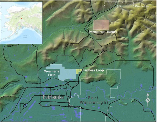
ABoVE: End of Season Snow Depth at CRREL sites near Fairbanks, Alaska, 2014-2019
National Aeronautics and Space Administration —
This dataset provides 20,582 snow depth measurements collected at six sites near Fairbanks, Alaska, USA. Measurements were made during March or April from 2014-2019.... -
Federal
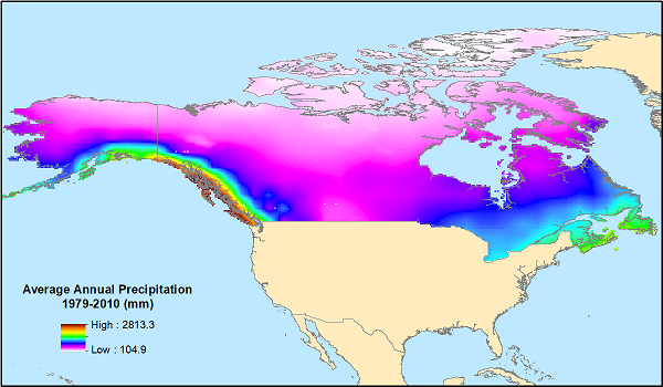
ABoVE: Monthly Hydrological Fluxes for Canada and Alaska, 1979-2018
National Aeronautics and Space Administration —
This dataset provides modeled estimates of monthly hydrological fluxes at 0.25-degree resolution over Alaska and Canada for the years 1979-2018. The estimates were... -
Federal
ABoVE: Soil Active Layer Thaw Depths at CRREL sites near Fairbanks, Alaska, 2014-2018
National Aeronautics and Space Administration —
This dataset provides soil active layer thaw depth measurements collected along transects at three sites near Fairbanks, Alaska, USA. Measurements were made during... -
Federal
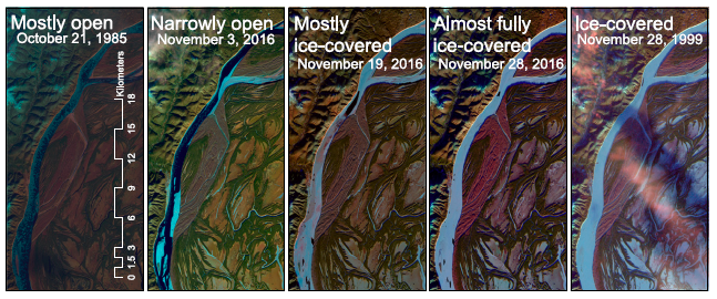
ABoVE: River Ice Breakup and Freeze-up Stages, Yukon River Basin, Alaska, 1972-2016
National Aeronautics and Space Administration —
This dataset provides estimates of river ice breakup and freeze-up stages along selected reaches of the Yukon and Tanana Rivers in the Yukon River Basin in interior...

Official websites use .gov
A
.gov website belongs to an official government
organization in the United States.
Secure .gov websites use HTTPS
A
lock (
) or https:// means you’ve safely connected to
the .gov website. Share sensitive information only on official,
secure websites.