

32 datasets found for "Reserve"
-
Federal
LBA-ECO CD-02 C and N Isotopes in Leaves and Atmospheric CO2, Amazonas, Brazil
National Aeronautics and Space Administration —
This data set reports delta 13C/12C results for leaf tissues and atmospheric carbon dioxide (CO2), 15N/14N ratios for leaf tissue, and leaf carbon and nitrogen... -
Federal
Pre-LBA Anglo-Brazilian Amazonian Climate Observation Study (ABRACOS) Data
National Aeronautics and Space Administration —
The data set presents the principal data from the Anglo-BRazilian Amazonian Climate Observation Study (ABRACOS) (Gash et al, 1996) and provides quality controlled... -
Federal
LBA-ECO CD-08 Tree Inventory Data, Ducke Reserve, Manaus, Brazil: 1999
National Aeronautics and Space Administration —
This data set includes in one data file the common names, base diameters, and calculated tree masses for almost 3,000 trees on a 5 hectare plot (20 x 2,500 m) located... -
Federal
LBA-ECO TG-07 Seasonal Trace Gas Profiles in Brazilian Amazon Forests: 2004-2005
National Aeronautics and Space Administration —
This data set provides concentrations of carbon dioxide (CO2), methane (CH4), and nitrous oxide (N2O) from air samples collected at several heights on towers at three... -
Federal
NPP Grassland: Central Plains Experimental Range (SGS), USA, 1939-1990, R1
National Aeronautics and Space Administration —
This data set records the productivity of a semiarid shortgrass prairie steppe located in the Central Plains Experimental Reserve (CPER)/Pawnee National Grassland in... -
Federal
RLC Forest Stand Carbon Map of Russia
National Aeronautics and Space Administration —
This dataset is a 1:15 million scale map of forest stand carbon for the land area of Russia (Stone et al., 2000). The objective was to create a first approximation of... -
Federal
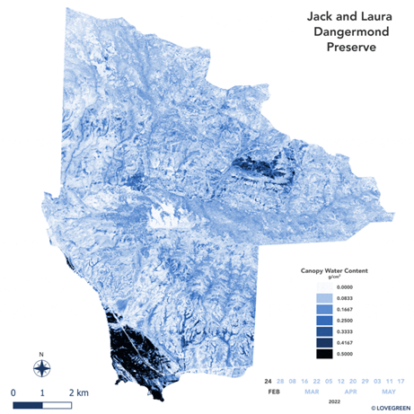
SHIFT: AVIRIS-NG Derived Gridded Mosaicked Canopy Water Content, California, 2022
National Aeronautics and Space Administration —
This dataset provides per-pixel vegetation canopy water content (CWC) derived from surface reflectance measured by the Airborne Visible/Infrared Imaging Spectrometer-... -
Federal
CMS: Mangrove Canopy Height from High-resolution Stereo Image Pairs, Mozambique, 2012
National Aeronautics and Space Administration —
This data set provides canopy height estimates for mangrove forests at 0.6 x 0.6 m resolution in three study sites located in southeastern Mozambique, Africa: two...
32 datasets found for "Reserve"