
-
University
Cadastral PLSS Standardized Data - PLSSQuarterReference, NW - Version 1.1
Earth Data Analysis Center, University of New Mexico —
This feature class is part of the Cadastral National Spatial Data Infrastructure (NSDI) CADNSDI publication data set for rectangular and non-rectangular Public Land... -
Federal
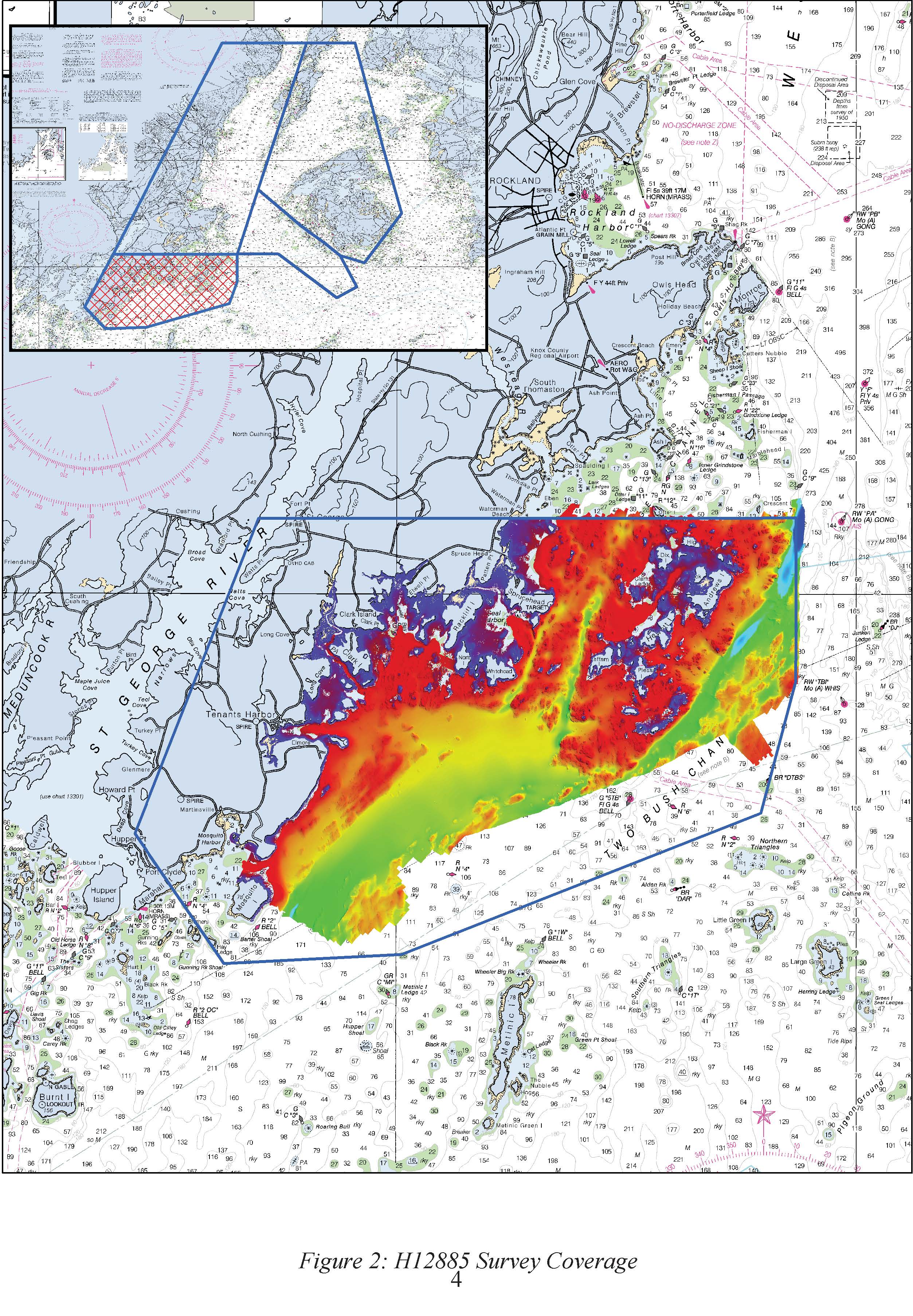
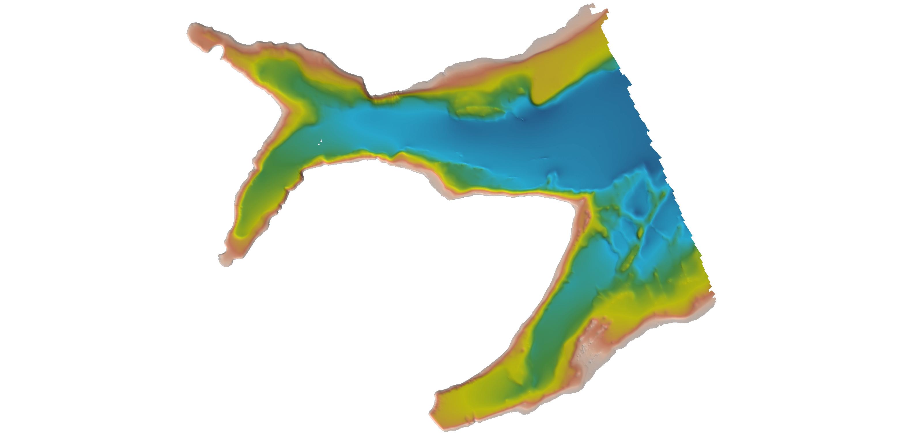
H12885: NOS Hydrographic Survey , 2016-09-29
National Oceanic and Atmospheric Administration, Department of Commerce —
The National Oceanic and Atmospheric Administration (NOAA) has the statutory mandate to collect hydrographic data in support of nautical chart compilation for safe... -
Federal
H11195: NOS Hydrographic Survey , Southwest Alaska Peninsula, Alaska, 2003-06-06
National Oceanic and Atmospheric Administration, Department of Commerce —
The National Oceanic and Atmospheric Administration (NOAA) has the statutory mandate to collect hydrographic data in support of nautical chart compilation for safe... -
Federal
H13449: NOS Hydrographic Survey , 2021-07-21
National Oceanic and Atmospheric Administration, Department of Commerce —
The National Oceanic and Atmospheric Administration (NOAA) has the statutory mandate to collect hydrographic data in support of nautical chart compilation for safe... -
Federal
H13115: NOS Hydrographic Survey , 2018-07-21
National Oceanic and Atmospheric Administration, Department of Commerce —
The National Oceanic and Atmospheric Administration (NOAA) has the statutory mandate to collect hydrographic data in support of nautical chart compilation for safe... -
Federal
MODIS/Terra Sea Ice Extent Daily L3 Global 1km EASE-Grid Night V061 NGDA
National Aeronautics and Space Administration —
This global Level-3 (L3) data set provides daily nighttime ice surface temperature derived from the 'MODIS/Terra Sea Ice Extent 5-Min L2 Swath 1km'... -
Federal
D00223: NOS Hydrographic Survey , 2016-10-11
National Oceanic and Atmospheric Administration, Department of Commerce —
The National Oceanic and Atmospheric Administration (NOAA) has the statutory mandate to collect hydrographic data in support of nautical chart compilation for safe... -
Federal
H13838: NOS Hydrographic Survey , 2024-02-03
National Oceanic and Atmospheric Administration, Department of Commerce —
The National Oceanic and Atmospheric Administration (NOAA) has the statutory mandate to collect hydrographic data in support of nautical chart compilation for safe... -
Federal
Grid Cells and Modeled Groundwater Levels to Characterize Hydrologic Conditions for Public-supply Aquifers in California's Central Valley, 1990-2020
Department of the Interior —
This data release documents grid cells and modeled groundwater levels for hydrologic characterization of aquifer areas used for public drinking-water supply in... -
Federal
CONUS404: Four-kilometer long-term regional hydroclimate reanalysis over the conterminous United States (ver. 2.0, December 2023)
Department of the Interior —
This metadata record serves as documentation for the authoritative version of the CONUS404 atmospheric forcing dataset. CONUS404 is an abbreviated description for the... -
Federal
Alaska 2 Arc-second Digital Elevation Models (DEMs) - USGS National Map 3DEP Downloadable Data Collection
Department of the Interior —
This is a tiled collection of the 3D Elevation Program (3DEP) and is 2 arc-second (approximately 60 m) resolution covering Alaska. The elevations in this Digital... -
Federal
H12480: NOS Hydrographic Survey , Eastern Long Island Sound, 2012-10-10
National Oceanic and Atmospheric Administration, Department of Commerce —
The National Oceanic and Atmospheric Administration (NOAA) has the statutory mandate to collect hydrographic data in support of nautical chart compilation for safe... -
Federal
H13112: NOS Hydrographic Survey , 2018-07-21
National Oceanic and Atmospheric Administration, Department of Commerce —
The National Oceanic and Atmospheric Administration (NOAA) has the statutory mandate to collect hydrographic data in support of nautical chart compilation for safe... -
Federal
H13207: NOS Hydrographic Survey , 2019-12-04
National Oceanic and Atmospheric Administration, Department of Commerce —
The National Oceanic and Atmospheric Administration (NOAA) has the statutory mandate to collect hydrographic data in support of nautical chart compilation for safe... -
Federal
H12113: NOS Hydrographic Survey , San Fransisco Bay, California, 2009-08-03
National Oceanic and Atmospheric Administration, Department of Commerce —
The National Oceanic and Atmospheric Administration (NOAA) has the statutory mandate to collect hydrographic data in support of nautical chart compilation for safe... -
Federal
F00840: NOS Hydrographic Survey , 2021-09-03
National Oceanic and Atmospheric Administration, Department of Commerce —
The National Oceanic and Atmospheric Administration (NOAA) has the statutory mandate to collect hydrographic data in support of nautical chart compilation for safe... -
Federal
H13063: NOS Hydrographic Survey , Mississippi Sound and Vicinity, 2017-11-30
National Oceanic and Atmospheric Administration, Department of Commerce —
The National Oceanic and Atmospheric Administration (NOAA) has the statutory mandate to collect hydrographic data in support of nautical chart compilation for safe... -
University
1935 15' Quad #074 Aerial Photo Mosaic Index
Earth Data Analysis Center, University of New Mexico —
Aerial Photo Reference Mosaics contain aerial photographs that are retrievable on a frame by frame basis. The inventory contains imagery from various sources that are... -
Federal
CoSMoS (Coastal Storm Modeling System) Southern California v3.0 Phase 2 flood-hazard projections: 100-year storm in San Diego County
Department of the Interior —
Projected Hazard: Geographic extent of projected coastal flooding, low-lying vulnerable areas, and maxium/minimum flood potential associated with the sea-level rise... -
Federal
H12321: NOS Hydrographic Survey , Central Chesapeake Bay, MD, 2011-05-18
National Oceanic and Atmospheric Administration, Department of Commerce —
The National Oceanic and Atmospheric Administration (NOAA) has the statutory mandate to collect hydrographic data in support of nautical chart compilation for safe...

Official websites use .gov
A
.gov website belongs to an official government
organization in the United States.
Secure .gov websites use HTTPS
A
lock (
) or https:// means you’ve safely connected to
the .gov website. Share sensitive information only on official,
secure websites.
.jpg)
.jpg)