
-
Federal
PacIOOS Ocean Gliders: SeaGlider 139: Mission 7
National Oceanic and Atmospheric Administration, Department of Commerce —
As a part of PacIOOS, ocean gliders provide very detailed information about the physical and chemical condition of the waters around the Hawaiian Islands.... -
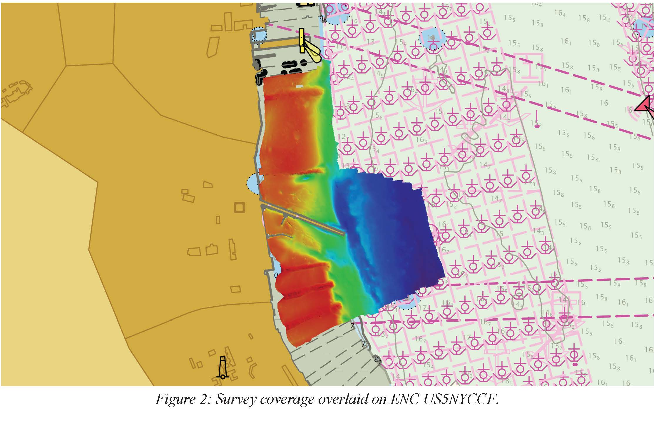
Federal
F00657: NOS Hydrographic Survey , 2015-08-12
National Oceanic and Atmospheric Administration, Department of Commerce —
The National Oceanic and Atmospheric Administration (NOAA) has the statutory mandate to collect hydrographic data in support of nautical chart compilation for safe... -
Federal
HERO WEC V1.0 - Electrical PTO Deployment Data and Analysis
Department of Energy —
This submission includes the processed and raw field electrical data from NREL's August 2022 HERO WEC (hydraulic and electric reverse osmosis wave energy converter)... -
Federal
F00799: NOS Hydrographic Survey , 2022-05-13
National Oceanic and Atmospheric Administration, Department of Commerce —
The National Oceanic and Atmospheric Administration (NOAA) has the statutory mandate to collect hydrographic data in support of nautical chart compilation for safe... -
Federal
CeNCOOS in situ water monitoring data at Romberg Tiburon Center Pier
National Oceanic and Atmospheric Administration, Department of Commerce —
The Tiburon shore station is maintained by San Francisco State University. The station has been operational since 2002 and consists of both in-water and... -
Federal
H13810: NOS Hydrographic Survey , 2023-10-03
National Oceanic and Atmospheric Administration, Department of Commerce —
The National Oceanic and Atmospheric Administration (NOAA) has the statutory mandate to collect hydrographic data in support of nautical chart compilation for safe... -
State
Granted Lands
State of California —
SummaryThis INCOMPLETE dataset illustrates California's Granted public trust lands. Parcel digitization is currently UNDER DEVELOPMENT and approximately 61% complete... -
Federal
CalHABMAP - HABs Scripps Pier data
National Oceanic and Atmospheric Administration, Department of Commerce —
The California Harmful Algal Bloom Monitoring and Alert Program (CalHABMAP) collects weekly phytoplankton and water quality data at eight piers along the Central and... -
Federal
Physical, meteorological, and biological data collected from non-federal stations assembled by the Northwest Association of Networked Ocean Observing Systems (NANOOS)
National Oceanic and Atmospheric Administration, Department of Commerce —
This dataset contains physical, meteorological and geochemical data, collected at moorings located in Puget Sound, WA and along the Washington and Oregon coasts. The... -
Hydrography Lines
District of Columbia —
This layer contains hydrography such as streams, rivers, and other linear hydrography features. Hidden hydrography, inferred drainage connectors, or culverts connect... -
Federal
F00146: NOS Hydrographic Survey , 1957-03-12
National Oceanic and Atmospheric Administration, Department of Commerce —
The National Oceanic and Atmospheric Administration (NOAA) has the statutory mandate to collect hydrographic data in support of nautical chart compilation for safe... -
Federal
Sensor continuous measurements of pH, partial pressure of carbon dioxide (pCO2), salinity and temperature at the University of Texas Marine Science Institute Research Pier, Aransas Ship Channel, TX, Gulf of Mexico from 2016-11-08 to 2017-08-23 (NCEI Accession 0222572)
National Oceanic and Atmospheric Administration, Department of Commerce —
This dataset consists of hourly continuous measurements of pH, partial pressure of carbon dioxide (pCO2), salinity and temperature were collected at the University of... -
Federal
Oceanographic and biological water parameter data collected from the M45X mooring in Lake Michigan, Great Lakes region to support the long-term ecological research Muskegon transect studies by NOAA Great Lakes Environmental Research Laboratory from 2021-09-28 to 2022-05-17 (NCEI Accession 0276519)
National Oceanic and Atmospheric Administration, Department of Commerce —
One mooring was deployed near the M45 station by the NOAA Great Lakes Environmental Research Laboratory (GLERL) from September 2021 to May 2022. These observations... -
Federal
Trident Pier, Port Canaveral, FL Predictions (TRDF1)
National Oceanic and Atmospheric Administration, Department of Commerce —
Timeseries data from 'Trident Pier, Port Canaveral, FL Predictions (TRDF1)' (noaa_nos_co_ops_8721604_predicti) -
Federal
PacIOOS Nearshore Sensor 010: Maunalua Bay, Oahu, Hawaii
National Oceanic and Atmospheric Administration, Department of Commerce —
The nearshore sensors are part of the Pacific Islands Ocean Observing System (PacIOOS) and are designed to measure a variety of ocean parameters at fixed points.... -
Federal
CalHABMAP - HABs Humboldt data
National Oceanic and Atmospheric Administration, Department of Commerce —
The California Harmful Algal Bloom Monitoring and Alert Program (CalHABMAP) collects weekly phytoplankton and water quality data at eight piers along the Central and... -
City
Licenses and Inspections Building Certifications
City of Philadelphia —
Certain buildings in the City of Philadelphia require periodic inspections. These inspections are performed by licensed inspection companies. Buildings that contain... -
State
Topo Survey Sheet 1880s Shore
State of Connecticut —
Connecticut Historic Shoreline Wetlands: 1880s NOS T-Sheet Shoreline Features is a 1:10,000-scale, line feature-based layer that includes information depicting... -
State
Shellfish Area Marker
State of Connecticut —
Shellfish Area Classification Set: The Connecticut Department of Environmental Protection cooperated with the Department of Agriculture, Bureau of Aquaculture to... -
Federal
Oceanographic data collected from non-federal stations assembled by the Great Lakes Observing System (GLOS)
National Oceanic and Atmospheric Administration, Department of Commerce —
This dataset contains oceanographic and surface meteorological data collected from non-Federal stations throughout the Great Lakes region of the United States. The...

Official websites use .gov
A
.gov website belongs to an official government
organization in the United States.
Secure .gov websites use HTTPS
A
lock (
) or https:// means you’ve safely connected to
the .gov website. Share sensitive information only on official,
secure websites.