
-
Federal
Flood inundation map geospatial datasets for Lake Ontario, New York (ver. 2.0, November 2021)
Department of the Interior —
Static flood inundation boundary extents were created along the entire shoreline of Lake Ontario in Cayuga, Jefferson, Monroe, Niagara, Orleans, Oswego, and Wayne... -
Federal
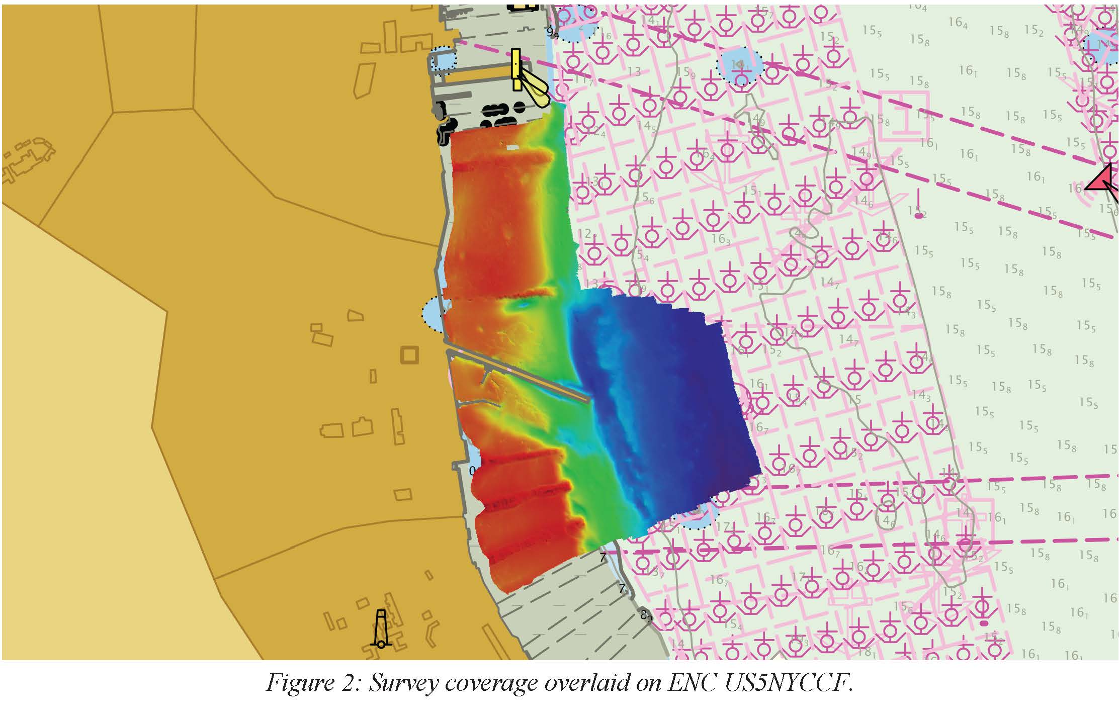
H13092: NOS Hydrographic Survey , 2017-11-09
National Oceanic and Atmospheric Administration, Department of Commerce —
The National Oceanic and Atmospheric Administration (NOAA) has the statutory mandate to collect hydrographic data in support of nautical chart compilation for safe... -
Federal
Assessment of invasiveness of the Orange Keyhole Sponge, Mycale Armata, in Kaneohe Bay Oahu, Hawaii, based on surveys 2004-2005 (NCEI Accession 0002602)
National Oceanic and Atmospheric Administration, Department of Commerce —
The Orange Keyhole Sponge, Mycale armata Thiele, was unknown in Hawaii prior to 1996. First reported in Pearl Harbor, it now occurs in virtually every commercial... -
Federal
SeaBASS Bio-optical and pigment data collected from 1979-08-22 to 2011-12-14 (NCEI Accession 0086308)
National Oceanic and Atmospheric Administration, Department of Commerce —
This dataset contains SeaWiFS Bio-optical Archive and Storage System (SeaBASS) bio-optical, pigment, and other data collected from 1979-08-22 to 2011-12-14. Archived... -
Federal
Geospatial Data for Bridge Scour Countermeasure Assessments at Select Bridges in the United States, 2016–18
Department of the Interior —
Scouring of streambed material surrounding bridge structures is a leading cause of bridge failure in the United States. Damages resulting from bridge failure... -
Federal
Cherry Grove Pier
National Oceanic and Atmospheric Administration, Department of Commerce —
Timeseries data from 'Cherry Grove Pier' (cherry-grove-pier) -
Federal
F00789: NOS Hydrographic Survey , 2019-10-25
National Oceanic and Atmospheric Administration, Department of Commerce —
The National Oceanic and Atmospheric Administration (NOAA) has the statutory mandate to collect hydrographic data in support of nautical chart compilation for safe... -
Federal
F00775: NOS Hydrographic Survey , 2019-06-04
National Oceanic and Atmospheric Administration, Department of Commerce —
The National Oceanic and Atmospheric Administration (NOAA) has the statutory mandate to collect hydrographic data in support of nautical chart compilation for safe... -
Federal
PacIOOS Nearshore Sensor 016: Wailupe, Oahu, Hawaii
National Oceanic and Atmospheric Administration, Department of Commerce —
The nearshore sensors are part of the Pacific Islands Ocean Observing System (PacIOOS) and are designed to measure a variety of ocean parameters at fixed points.... -
State
Charm City Circulator Stops
State of Maryland —
This layer contains the bus stops of the four circulators (Purple, Green, Orange, Banner) as well as the landings/piers for the three Harbor Connector Ferry Routes.... -
Federal
CO-OPS station 9414863: RICHMOND, CHEVRON OIL PIER 1-minute Raw Tsunami Water Level Data
National Oceanic and Atmospheric Administration, Department of Commerce —
CO-OPS has been involved with tsunami warning and mitigation since the Coast and Geodetic Survey started the Tsunami Warning System in 1948 to provide warnings to the... -
Federal
Coral disease data by transect, West Hawaii, 2011
Department of the Interior —
Observations of coral disease and health indicators were documented by scuba divers along pre-determined transects and are presented here in comma-separated format.... -
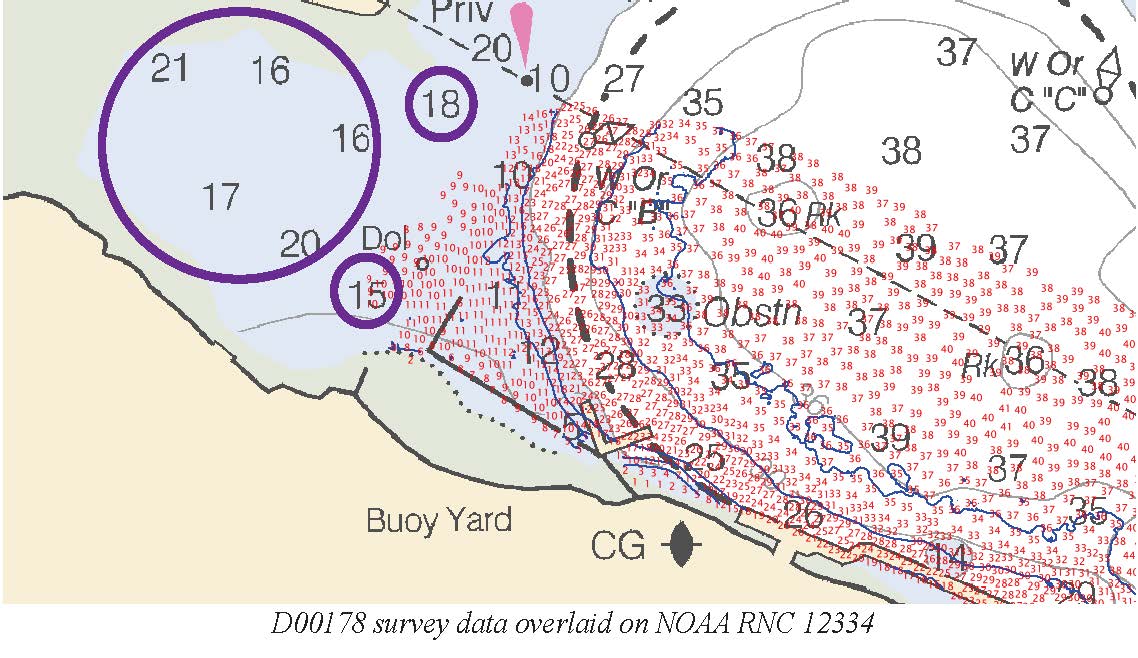
Federal
D00178: NOS Hydrographic Survey , 2013-04-29
National Oceanic and Atmospheric Administration, Department of Commerce —
The National Oceanic and Atmospheric Administration (NOAA) has the statutory mandate to collect hydrographic data in support of nautical chart compilation for safe... -
Federal
Raw continuous resistivity profile data collected by the U.S. Geological Survey in Great South Bay on Long Island, New York, on May 21, 2008
Department of the Interior —
An investigation of submarine aquifers adjacent to the Fire Island National Seashore and Long Island, New York, was conducted to assess the importance of submarine... -
Federal
F00799: NOS Hydrographic Survey , 2022-05-13
National Oceanic and Atmospheric Administration, Department of Commerce —
The National Oceanic and Atmospheric Administration (NOAA) has the statutory mandate to collect hydrographic data in support of nautical chart compilation for safe... -
City
108" Inundation Vulnerability Zone Line (Sea Level Rise + 100YR Flood Event)
City of San Francisco —
Disclaimer: The Sea Level Rise (SLR) map shows the most extreme level of SLR possible. It is a very, very unlikely scenario that would only occur if no efforts to... -
Federal
CO-OPS station 8771450: GALVESTON PIER 21, GALVESTON CHANNEL 1-minute Raw Tsunami Water Level Data
National Oceanic and Atmospheric Administration, Department of Commerce —
CO-OPS has been involved with tsunami warning and mitigation since the Coast and Geodetic Survey started the Tsunami Warning System in 1948 to provide warnings to the... -
Federal
SCCOOS Automated Shore Station - Newport Beach Pier
National Oceanic and Atmospheric Administration, Department of Commerce —
Timeseries data from 'Newport Beach Pier Automated Shore Station' (newport-pier-automated-shore-sta) -
City
Licenses and Inspections Building Certifications
City of Philadelphia —
Certain buildings in the City of Philadelphia require periodic inspections. These inspections are performed by licensed inspection companies. Buildings that contain...

Official websites use .gov
A
.gov website belongs to an official government
organization in the United States.
Secure .gov websites use HTTPS
A
lock (
) or https:// means you’ve safely connected to
the .gov website. Share sensitive information only on official,
secure websites.