
-
Federal
AQUA MODIS High Resolution Level 3 monthly aerosol data, 0.1x0.1 degree grid Version 001 (AER_DBDT_M10KM_L3_MODIS_AQUA) at GES DISC
National Aeronautics and Space Administration —
This High-Resolution (0.1 x 0.1 degree) Level 3 monthly Aerosol Optical Depth (AOD) product is generated by combining two Moderate Resolution Imaging... -
Federal
ADVANCED MICROWAVE SOUNDING UNIT-A (AMSU-A) SWATH FROM NOAA-16 V1
National Aeronautics and Space Administration —
AMSU-A, the Advanced Microwave Sounding Unit, is a 15-channel passive microwave radiometer used to profile atmospheric temperature and moisture from the earth's... -
Federal
2023 National Offshore Wind data set (NOW-23)
Department of Energy —
The 2023 National Offshore Wind data set (NOW-23) is the latest wind resource data set for offshore regions in the United States, which supersedes, for its offshore... -
Federal
NACP Site: Terrestrial Biosphere Model and Aggregated Flux Data in Standard Format
National Aeronautics and Space Administration —
This data set provides standardized output variables for gross primary productivity (GPP), net ecosystem exchange (NEE), leaf area index (LAI), ecosystem respiration... -
Federal
ITPR/Nimbus-5 Level 1 Calibrated Radiances V001 (ITPRN5L1) at GES DISC
National Aeronautics and Space Administration —
ITPRN5L1 is the Nimbus-5 Infrared Temperature Profile Radiometer (ITPR) Level-1 Calibrated Radiances data product which contains radiances at 7 infrared spectral... -
Federal
Delta-X: Delft3D Sediment Model, Site 322, Terrebonne Basin, MRD, Louisiana, USA
National Aeronautics and Space Administration —
This dataset contains the Delft3D model of the intensive site 322 in the Terrebonne Basin along the Mississippi River Delta (MRD) in coastal Louisiana. Simulations... -
Federal
CERES-MODIS and hourly geostationary cloud properties stratified by ISCCP cloud types for day and night.
National Aeronautics and Space Administration —
CER_CldTypHist_GEO-MODIS_Edition4A is the Clouds and the Earth's Radiant Energy System (CERES)- Moderate-Resolution Imaging Spectroradiometer (MODIS) and hourly... -
Federal
Sounder SIPS: AQUA AIRS IR MW Level 3 CLIMCAPS : Specific Quality Control Gridded Daily V2 at GES DISC
National Aeronautics and Space Administration —
WARNING: Users of the derived product “co_mmr_midtrop” (carbon monoxide mass mixing ratio to dry air [kg/kg] at ~500 hPa). This variable has a significant bias due to... -
Federal
NACP Site: Terrestrial Biosphere Model Output Data in Original Format
National Aeronautics and Space Administration —
This data set contains the original model output data submissions from the 24 terrestrial biosphere models (TBM) that participated in the North American Carbon... -
Federal
Sentinel-6A Level 1B GNSS Radio Occultation Daily RINEX V1 (S6A_RO_1B_POD_RNX_) at GES DISC
National Aeronautics and Space Administration —
This dataset provides the L1B Global Navigation Satellite System (GNSS) Radio Occultation (RO) Precise Orbit Determination (POD) data generated by NASA JPL from... -
Federal
NOAA20 VIIRS High Resolution Level 3 daily aerosol data, 0.1x0.1 degree grid Version 001 (AER_DBDT_D10KM_L3_VIIRS_NOAA20) at GES DISC
National Aeronautics and Space Administration —
This High-Resolution (0.1 x 0.1 degree) Level 3 daily Aerosol Optical Depth (AOD) product is generated by combining two Visible Infrared Imaging Radiometer Suite... -
Federal
Sentinel-5P TROPOMI Near-Real-Time (NRT) Sulphur Dioxide SO2 1-Orbit L2 5.5km x 3.5km V2 (S5P_L2__SO2____HiR_NRT) at GES DISC
National Aeronautics and Space Administration —
The Sentinel-5P TROPOMI Near Real Time (NRT) Sulphur Dioxide SO2 1-Orbit L2 5.5km x 3.5km V2 (S5P_L2__SO2_HiRNRT) at GES DISC is the near real time version of the... -
Federal
Sentinel-5P TROPOMI Tropospheric Formaldehyde HCHO 1-Orbit L2 7km x 3.5km V1 (S5P_L2__HCHO__) at GES DISC
National Aeronautics and Space Administration —
Starting from August 6th in 2019, Sentinel-5P TROPOMI along-track high spatial resolution (~5.5km at nadir) has been implemented. Starting from July 13th in 2020,... -
Federal
Biome-BGC: Terrestrial Ecosystem Process Model, Version 4.1.1
National Aeronautics and Space Administration —
Biome-BGC is a computer program that estimates fluxes and storage of energy, water, carbon, and nitrogen for the vegetation and soil components of terrestrial... -
Federal
Process-structure-properties investigations for laser powder bed fused IN718 in the as-built condition
Department of Commerce —
This data repository provides a central location for a body of work using one build of nickel-based alloy 718 (IN718) material and resulted in three different... -
Federal
TRMM Precipitation Radar Rainfall Rate and Profile L2 1.5 hours V7 (TRMM_2A25) at GES DISC
National Aeronautics and Space Administration —
The new version of these data is in GPM-like format (consistent with the GPM Dual-frequency Radar data format), and can be found under the name GPM_2APR. The TRMM... -
Federal
ASTER Digital Elevation Model V004
National Aeronautics and Space Administration —
The Terra Advanced Spaceborne Thermal Emission and Reflection Radiometer (ASTER) Digital Elevation Model (AST14DEM) product is generated using bands 3N (nadir-... -
Federal
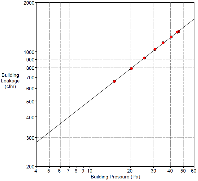
Field Testing of Compartmentalization Methods for Multifamily Construction - Washington DC
Department of Energy —
BSC TO5 Task 2.1 Field Testing of Compartmentalization Methods for Multifamily Construction - Capitol Heights, MD 20743 A building comprising five vertical townhome...

Official websites use .gov
A
.gov website belongs to an official government
organization in the United States.
Secure .gov websites use HTTPS
A
lock (
) or https:// means you’ve safely connected to
the .gov website. Share sensitive information only on official,
secure websites.