
-
Federal
Sentinel-5P TROPOMI Tropospheric Formaldehyde HCHO 1-Orbit L2 7km x 3.5km V1 (S5P_L2__HCHO__) at GES DISC
National Aeronautics and Space Administration —
Starting from August 6th in 2019, Sentinel-5P TROPOMI along-track high spatial resolution (~5.5km at nadir) has been implemented. Starting from July 13th in 2020,... -
Federal
LBA-ECO CD-04 Soil Respiration, km 83 Tower Site, Tapajos National Forest, Brazil
National Aeronautics and Space Administration —
This data set reports on the flux of carbon dioxide from logged forest soils near the eddy flux tower at the km 83 site, Para, Brazil. The automated soil respiration... -
Federal
Regridded Harmonized World Soil Database v1.2
National Aeronautics and Space Administration —
This data set describes select global soil parameters from the Harmonized World Soil Database (HWSD) v1.2, including additional calculated parameters such as area... -
Federal
AQUA MODIS High Resolution Level 3 monthly aerosol data, 0.1x0.1 degree grid Version 001 (AER_DBDT_M10KM_L3_MODIS_AQUA) at GES DISC
National Aeronautics and Space Administration —
This High-Resolution (0.1 x 0.1 degree) Level 3 monthly Aerosol Optical Depth (AOD) product is generated by combining two Moderate Resolution Imaging... -
Federal
ASTER Digital Elevation Model V004
National Aeronautics and Space Administration —
The Terra Advanced Spaceborne Thermal Emission and Reflection Radiometer (ASTER) Digital Elevation Model (AST14DEM) product is generated using bands 3N (nadir-... -
Federal
Sentinel-5P TROPOMI Tropospheric NO2 1-Orbit L2 7km x 3.5km V1 (S5P_L2__NO2___) at GES DISC
National Aeronautics and Space Administration —
Starting from August 6th in 2019, Sentinel-5P TROPOMI along-track high spatial resolution (~5.5km at nadir) has been implemented. For data after August 6th of 2019,... -
Federal
Utah FORGE 3-2417: Low Frequency Distributed Acoustic Sensing Data from 16A/16B Stimulation - April, 2024
Department of Energy —
This dataset contains processed low-frequency Distributed Acoustic Sensing (LF-DAS) data collected between April 2 and April 12, 2024, during the Utah FORGE... -
Federal
Delta-X: Delft3D Sediment Model, Site 322, Terrebonne Basin, MRD, Louisiana, USA
National Aeronautics and Space Administration —
This dataset contains the Delft3D model of the intensive site 322 in the Terrebonne Basin along the Mississippi River Delta (MRD) in coastal Louisiana. Simulations... -
Federal
CERES-MODIS and hourly geostationary cloud properties stratified by ISCCP cloud types for day and night.
National Aeronautics and Space Administration —
CER_CldTypHist_GEO-MODIS_Edition4A is the Clouds and the Earth's Radiant Energy System (CERES)- Moderate-Resolution Imaging Spectroradiometer (MODIS) and hourly... -
Federal
Sounder SIPS: AQUA AIRS IR MW Level 3 CLIMCAPS : Specific Quality Control Gridded Daily V2 at GES DISC
National Aeronautics and Space Administration —
WARNING: Users of the derived product “co_mmr_midtrop” (carbon monoxide mass mixing ratio to dry air [kg/kg] at ~500 hPa). This variable has a significant bias due to... -
Federal
Sentinel-6A Level 1B GNSS Radio Occultation Daily RINEX V1 (S6A_RO_1B_POD_RNX_) at GES DISC
National Aeronautics and Space Administration —
This dataset provides the L1B Global Navigation Satellite System (GNSS) Radio Occultation (RO) Precise Orbit Determination (POD) data generated by NASA JPL from... -
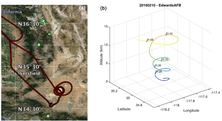
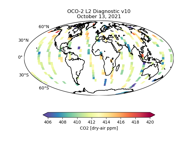
Federal
OCO-2 Level 2 geolocated XCO2 retrieval results and algorithm diagnostic information V11.2 (OCO2_L2_Diagnostic) at GES DISC
National Aeronautics and Space Administration —
Version 11.2 is the current version of the data set. Older versions will no longer be available and are superseded by Version 11.2. The Orbiting Carbon Observatory is... -
Federal
Biome-BGC: Terrestrial Ecosystem Process Model, Version 4.1.1
National Aeronautics and Space Administration —
Biome-BGC is a computer program that estimates fluxes and storage of energy, water, carbon, and nitrogen for the vegetation and soil components of terrestrial... -
Federal
Process-structure-properties investigations for laser powder bed fused IN718 in the as-built condition
Department of Commerce —
This data repository provides a central location for a body of work using one build of nickel-based alloy 718 (IN718) material and resulted in three different... -
Federal
TRMM Precipitation Radar Rainfall Rate and Profile L2 1.5 hours V7 (TRMM_2A25) at GES DISC
National Aeronautics and Space Administration —
The new version of these data is in GPM-like format (consistent with the GPM Dual-frequency Radar data format), and can be found under the name GPM_2APR. The TRMM... -
Federal
Sentinel-5P TROPOMI Total Ozone Column 1-Orbit L2 7km x 3.5km V1 (S5P_L2__O3_TOT) at GES DISC
National Aeronautics and Space Administration —
Starting from August 6th in 2019, Sentinel-5P TROPOMI along-track high spatial resolution (~5.5km at nadir) has been implemented. Starting from July 13th in 2020,... -
Federal
Kilauea Magnetotelluric Dataset
Department of Energy —
In 2002 and 2003 a collaborative effort was undertaken between Lawrence Berkeley National Laboratory, Sandia National Laboratories, the USGS Menlo Park, the USGS... -
Federal
Aboveground Biomass, Landcover, and Degradation, Kalimantan Forests, Indonesia, 2014
National Aeronautics and Space Administration —
This dataset provides estimates of aboveground biomass, percent canopy cover, mean canopy height, landcover, and forest degradation index products for forests in... -
Federal
LBA-ECO LC-08 Soil, Vegetation, and Land Cover Maps for Brazil and South America
National Aeronautics and Space Administration —
This data set provides (1) soil maps for Brazil that are digital versions of the MAPA DE SOLOS DO BRASIL (EMBRAPA, 1981) classified at three levels of detail,...

Official websites use .gov
A
.gov website belongs to an official government
organization in the United States.
Secure .gov websites use HTTPS
A
lock (
) or https:// means you’ve safely connected to
the .gov website. Share sensitive information only on official,
secure websites.