
-
Federal
BLM OR Greater Sage Grouse General and Priority Habitat Management Area Polygon Hub
Department of the Interior —
The purpose of this dataset is to record polygon features identified as Greater Sage-Grouse Priority and General Habitat Management Areas in Eastern Oregon for use in... -
Federal
NIST Thermophysical Properties of Hydrocarbon Mixtures Database- SRD 4
National Institute of Standards and Technology —
SUPERTRAPP is an interactive computer program for predicting thermodynamic and transport properties of pure fluids and fluid mixtures containing up to 20 components.... -
Federal
TRACE-A In Situ DC-8 Meteorology and Navigation Data
National Aeronautics and Space Administration —
TRACE-A_MetNav_AircraftInSitu_DC8_Data is the in situ meteorology and navigation data collected onboard the DC-8 aircraft during the Transport and Atmospheric... -
Federal
Gridded Population of the World, Version 4 (GPWv4): Basic Demographic Characteristics, Revision 11
National Aeronautics and Space Administration —
The Gridded Population of the World, Version 4 (GPWv4): Basic Demographic Characteristics, Revision 11 consists of estimates of human population by age and sex as... -
Federal
CERES-MODIS-VIIRS and hourly geostationary cloud properties stratified by ISCCP cloud types for day and night.
National Aeronautics and Space Administration —
CER_CldTypHist_GEO-MODIS-VIIRS_Edition4A is the Clouds and the Earth's Radiant Energy System (CERES)- Moderate-Resolution Imaging Spectroradiometer (MODIS) and... -
Federal
OrbView-2 SeaWiFS 4B Global Binned Garver-Siegel-Maritorena Model (GSM) Data, version R2022.0
National Aeronautics and Space Administration —
The SeaWiFS instrument was launched by Orbital Sciences Corporation on the OrbView-2 (a.k.a. SeaStar) satellite in August 1997, and collected data from September 1997... -
Federal
Chlorophyll-a, Orbview-2 SeaWiFS, R2018.0, 0.1°, Global, 1997-2010 (1 Day Composite), Lon0360
National Oceanic and Atmospheric Administration, Department of Commerce —
NASA GSFC Ocean Color Web distributes science-quality chlorophyll-a concentration data from the Sea-viewing Wide Field-of-view Sensor (SeaWiFS) on the Orbview-2... -
Federal
Aragonite saturation state gridded to 1x1 degree latitude and longitude at depth levels of 0, 50, 100, 200, 500, 1000, 2000, 3000, and 4000 meters in the global oceans (NCEI Accession 0139360)
National Oceanic and Atmospheric Administration, Department of Commerce —
This dataset contains gridded data of aragonite saturation state across the global oceans (spatial distributions with a resolution of 1x1 degree latitude and... -
Federal
2002-2017 Anthropogenic Emissions Data for AQ Model US
U.S. Environmental Protection Agency —
The US EPA developed a set of modeled meteorology, emissions, air quality and pollutant deposition spanning the years 2002 through 2019. Modeled datasets cover the... -
Federal
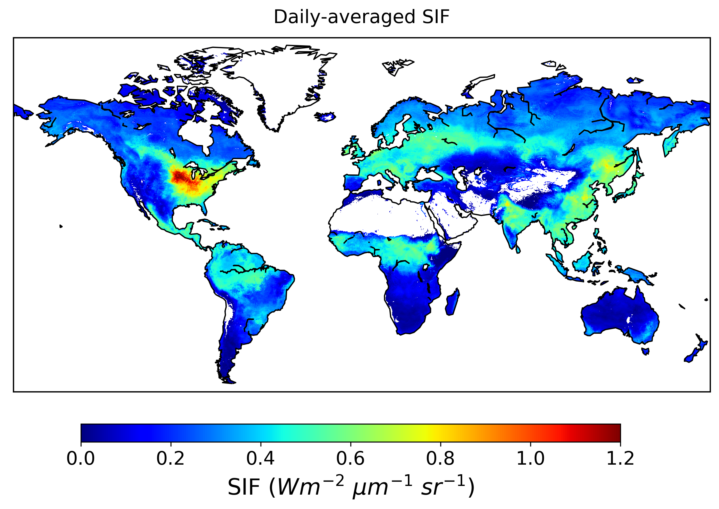
Global High-Resolution Estimates of SIF from Fused SCIAMACHY and GOME-2, V2
National Aeronautics and Space Administration —
This dataset provides global solar-induced chlorophyll fluorescence (SIF) estimates at a 0.05-degree resolution (approximately 5 km at the equator) for each month... -
Federal
Water Erosion Prediction Project (WEPP)
Department of Agriculture —
The Water Erosion Prediction Project (WEPP) model is a process-based, distributed parameter, continuous simulation, erosion prediction model for use on personal... -
Federal
Gridded Population of the World, Version 4 (GPWv4): Population Density, Revision 11
National Aeronautics and Space Administration —
The Gridded Population of the World, Version 4 (GPWv4): Population Density, Revision 11 consists of estimates of human population density (number of persons per... -
Federal
OMI/Aura Ozone (O3) Total Column 1-Orbit L2 Swath 13x24 km V003 NRT
National Aeronautics and Space Administration —
The OMI/Aura Level-2 Total Column Ozone Data Product OMTO3 Near Real Time data is made available from the OMI SIPS NASA for the public access. The Ozone Monitoring... -
Federal
ASTER Global Digital Elevation Model NetCDF V003
National Aeronautics and Space Administration —
The Terra Advanced Spaceborne Thermal Emission and Reflection Radiometer (ASTER) Global Digital Elevation Model (GDEM) Version 3 (ASTGTM) provides a global digital... -
Federal
Drought and Moisture Surplus for the Conterminous United States, Annual Data 1-Year Windows (Image Service)
Department of Agriculture —
The Moisture Deficit and Surplus map uses moisture difference z-score (MDZ) datasets developed by scientists Frank Koch, John Coulston, and William Smith of the... -
Federal
Aqua MODIS Level-1 Data NGDA
National Aeronautics and Space Administration —
MODIS (or Moderate Resolution Imaging Spectroradiometer) is a key instrument aboard the Terra (EOS AM) and Aqua (EOS PM) satellites. Terra's orbit around the Earth is... -
Federal
Ocean Color
National Aeronautics and Space Administration —
Satellite-derived Ocean Color Data sets from historical and currently operational NASA and International Satellite missions including the NASA Coastal Zone Color... -
Federal
R-Factor for Alaska
National Oceanic and Atmospheric Administration, Department of Commerce —
The rainfall-runoff erosivity factor (R-Factor) quantifies the effects of raindrop impacts and reflects the amount and rate of runoff associated with the rain. The... -
Federal
GOBAI-O2: A Global Gridded Monthly Dataset of Ocean Interior Dissolved Oxygen Concentrations Based on Shipboard and Autonomous Observations (NCEI Accession 0259304)
National Oceanic and Atmospheric Administration, Department of Commerce —
This dataset contains a global gridded data product of observation-based ocean interior dissolved oxygen concentrations. The data product is called GOBAI-O2 for...

Official websites use .gov
A
.gov website belongs to an official government
organization in the United States.
Secure .gov websites use HTTPS
A
lock (
) or https:// means you’ve safely connected to
the .gov website. Share sensitive information only on official,
secure websites.