

69 datasets found for "Crop Yield"
-
Federal
MaLi Fallow Study for Greenhouse gas Reduction through Agricultural Carbon Enhancement network in Mandan, North Dakota
Department of Agriculture —
The ‘Management Strategies for Soil Quality’ study was established in 1993 by Dr. Don Tanaka (USDA-ARS-NGPRL) to evaluate long-term impacts of minimum and no-till... -
Federal
ATP3 Unified Field Study Data
Department of Energy —
ATP3 Unified Field Study DataThe Algae Testbed Public-Private Partnership ATP3 was established with the goal of investigating open pond algae cultivation across... -
Federal
SMT Study for Greenhouse gas Reduction through Agricultural Carbon Enhancement network in St. Paul, Minnesota
Department of Agriculture —
SMT Study for Greenhouse gas Reduction through Agricultural Carbon Enhancement network in St. Paul, Minnesota Carbon and Nitrogen Storage are Greater under Biennial... -
Federal
Uniform Soybean Tests, Northern Region
Department of Agriculture —
The Uniform Soybean Tests, Northern Region, in place since 1941, evaluate yield, disease resistance, and quality traits of public breeding lines from northern states... -
Federal
Uniform Soybean Tests, Southern States
Department of Agriculture —
The Uniform Soybean Tests, Southern States, in place since 1943, evaluate yield, disease resistance, and quality traits of public breeding lines from the southern... -
Federal
ASRU Study for Greenhouse gas Reduction through Agricultural Carbon Enhancement network in Sidney, Montana
Department of Agriculture —
Information is needed to mitigate dryland soil greenhouse gas (GHG) emissions by using novel management practices. We evaluated the effects of cropping sequence and N... -
Federal
GrainGenes- A Global Data Repository for Small Grains
Department of Agriculture —
GrainGenes is an international, centralized crop database for peer-reviewed small grains data and information portal that serves the small grains research and... -
Federal
LUH2-ISIMIP2b Harmonized Global Land Use for the Years 2015-2100
National Aeronautics and Space Administration —
This dataset provides 0.25-degree gridded, global, annual estimates of fractional land use and land cover patterns for the period 2015-2100, designed to support the... -
Federal
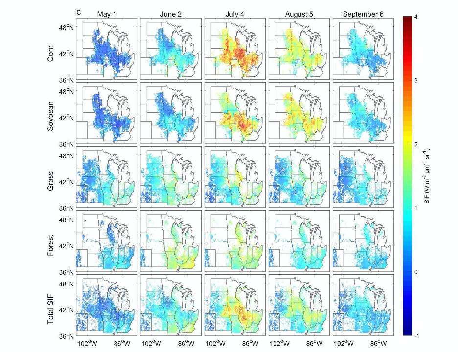
High Resolution Land Cover-Specific Solar-Induced Fluorescence, Midwestern USA, 2018
National Aeronautics and Space Administration —
This dataset provides estimated solar-induced chlorophyll fluorescence (SIF) of specific vegetation types and total SIF under clear-sky and real/cloudy conditions at... -
Federal
Global Food Security-support Analysis Data (GFSAD) Cropland Extent 2015 Europe, Central Asia, Russia, Middle East product 30 m V001
National Aeronautics and Space Administration —
The NASA Making Earth System Data Records for Use in Research Environments (MEaSUREs)... -
Federal
Potential Impacts of Climate Change on World Food Supply: Datasets from a Major Crop Modeling Study
National Aeronautics and Space Administration —
The Potential Impacts of Climate Change on World Food Supply: Datasets from a Major Crop Modeling Study contain projected country and regional changes in grain crop... -
Federal
Global Food Security-support Analysis Data (GFSAD) Cropland Extent 2015 Africa 30 m V001
National Aeronautics and Space Administration —
The NASA Making Earth System Data Records for Use in Research Environments (MEaSUREs)... -
Federal
Irrigator Pro
Department of Agriculture —
Irrigator Pro is an expert system designed to provide irrigation scheduling recommendations based on scientific data resulting in conservation minded irrigation... -
Federal
Stream water concentrations of herbicides and nutrients for sites in the northern Missouri and southern Iowa region, 1994 to 1999
Department of Agriculture —
The data set contains stream water concentrations of herbicides and nutrients for 153 sites in the northern Missouri/southern Iowa region from 1994 to 1995. The data... -
Federal
West Africa Coastal Vulnerability Mapping: Commercial Crop Production, 2000
National Aeronautics and Space Administration —
The West Africa Coastal Vulnerability Mapping: Commercial Crop Production, 2000 data set includes 5-minute rasters of crop production in metric tons per grid cell for... -
Federal
Noninsured Crop Disaster Assistance Program
Department of Agriculture —
USDA's Farm Service Agency's (FSA) Noninsured Crop Disaster Assistance Program (NAP) provides financial assistance to producers of noninsurable crops when low yields,... -
Federal
Irrigator Pro for Corn
Department of Agriculture —
Irrigator Pro is an expert system designed to provide irrigation scheduling recommendations based on scientific data resulting in conservation minded irrigation... -
Federal
Data and Code from: Association studies of salinity tolerance in sunflower provide robust breeding and selection strategies under climate change
Department of Agriculture —
Abstract Phytotoxic soil salinity is a global problem, and in the northern Great Plains and western Canada, salt accumulates on the surface of marine sediment soils... -
Federal
Geoecology: County-Level Environmental Data for the United States, 1941-1981
National Aeronautics and Space Administration —
The Geoecology database is a compilation of environmental data for the period 1941 to 1981. The Geoecology database contains selected data on terrain and soils, water... -
Federal
Data and code from: Wild sources for host plant resistance to <i>Bemisia tabaci</i> in watermelon: insights from behavioral and chemical analyses
Department of Agriculture —
This dataset includes all raw data and statistical software code required to reproduce the analyses and graphics in the manuscript:McKenzie-Reynolds, P., Owolabi,...
69 datasets found for "Crop Yield"