
-
Federal
OCO-2 Level 2 geolocated XCO2 retrievals results, physical model, Retrospective Processing V10r (OCO2_L2_Standard) at GES DISC
National Aeronautics and Space Administration —
Version 10r is the current version of the data set. Older versions will no longer be available and are superseded by Version 10r.In early 2021, the OCO Team... -
Federal
SARP 2017 Data
National Aeronautics and Space Administration —
SARP_2017_Data is the data collected onboard the Wallops C-23 aircraft during the 2017 deployment of the Student Airborne Research Program (SARP) mission. Data... -
Federal
Ground-based Observations of XCO2, XCH4, and XCO, Fairbanks, AK, 2016-2019
National Aeronautics and Space Administration —
This dataset provides ground-based column-averaged dry mole fractions (DMFs) of CO2 (xco2), CO (xco), CH4 (xch4), and N2O (xn2o) to supplement satellite-based... -
Federal
KORUS-AQ Hanseo King Air Aircraft In Situ Trace Gas Data
National Aeronautics and Space Administration —
KORUSAQ_TraceGas_AircraftInSitu_HanseoKingAir_Data are in-situ trace gas measurements collected onboard the Hanseo King Air aircraft during the KORUS-AQ field... -
Federal
LBA-ECO LC-04 IBIS Model Simulations for the Amazon and Tocantins Basins: 1921-1998
National Aeronautics and Space Administration —
The provided data were generated by the Integrated BIosphere Simulator (IBIS) terrestrial ecosystem model (Foley et al. 1996, Kucharik et al. 2000) using data from... -
Federal
Measurement of Air Pollution from Satellites (MAPS) Office of Space and Terrestrial Applications - 3 (OSTA3) Carbon Monoxide 5 degree by 5 degree data
National Aeronautics and Space Administration —
MAPS Overview The MAPS experiment measures the global distribution of carbon monoxide (CO) mixing ratios in the free troposphere. Because of MAPS' previous flights on... -
Federal
ABoVE: CO2 and CH4 Fluxes and Meteorology at Flux Tower Sites, Alaska, 2015-2017
National Aeronautics and Space Administration —
This dataset provides CO2 and CH4 fluxes and meteorological parameters from five eddy covariance (EC) tower sites located at Barrow (three sites), Atqasuk (ATQ) and... -
Federal
LISTOS Stony Brook Aircraft In-Situ Data
National Aeronautics and Space Administration —
LISTOS_AircraftInSitu_StonyBrookAircraft_Data is the Long Island Sound Tropospheric Ozone Study (LISTOS) in-situ data collected onboard the Stony Brook Aircraft... -
Federal
Sounder SIPS: AQUA AIRS IR + MW Level 2 CLIMCAPS: Atmosphere, cloud and surface geophysical state V2 (SNDRAQIML2CCPRET) at GES DISC
National Aeronautics and Space Administration —
WARNING: To users of the derived product “co_mmr_midtrop” (carbon monoxide mass mixing ratio to dry air [kg/kg] at ~500 hPa). This variable has a significant bias due... -
Federal
CAR Discover AQ BRDF Measurements V2 (CAR_DISCOVERAQ_BRDF_2)
National Aeronautics and Space Administration —
DISCOVER-AQ, a NASA Earth Venture program funded mission, stands for Deriving Information on Surface Conditions from Column and Vertically Resolved Observations... -
Federal
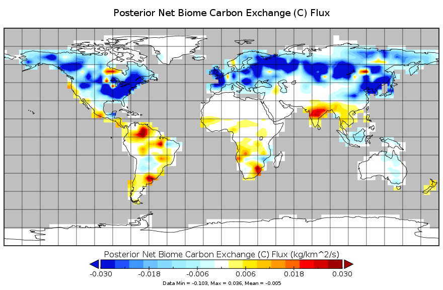
Carbon Monitoring System Flux for Posterior Total Carbon L4 V1 (CMSFluxTotalpost) at GES DISC
National Aeronautics and Space Administration —
This dataset provides the Carbon Flux for Posterior Total Carbon.The NASA Carbon Monitoring System (CMS) is designed to make significant contributions in... -
Federal
CAMP2Ex P-3 In-Situ Trace Gas Data
National Aeronautics and Space Administration —
CAMP2Ex_TraceGas_AircraftInSitu_P3_Data are in-situ trace gas measurements conducted onboard the P-3 aircraft during the Clouds, Aerosol and Monsoon Processes-... -
Federal
SARP 2024 Data
National Aeronautics and Space Administration —
SARP_2024_Data is the data collected onboard the NASA P-3B and the Dynamic Aviation B200 aircrafts during the 2024 deployment of the Student Airborne Research Program... -
Federal
CAR FIREACE Arctic Ice and Cloud Radiation BRDF V2 (CAR_FIREACE_BRDF) at GES DISC
National Aeronautics and Space Administration —
The scientific objectives of FIRE/ACE are to study impact of Arctic clouds on radiation exchange between surface, atmosphere, and space, and the influence of surface... -
Federal
MOPITT CO gridded daily means (Near and Thermal Infrared Radiances) V009
National Aeronautics and Space Administration —
MOP03J_9 is the Measurements Of Pollution In The Troposphere (MOPITT) Carbon Monoxide (CO) gridded daily means (Near and Thermal Infrared Radiances) version 9 data... -
Federal
SARP-East 2023 Data
National Aeronautics and Space Administration —
SARP_2023_East_Data is the ground site data and data collected onboard the Dynamic Aviation B200 aircraft during the 2023 deployment of the Student Airborne Research... -
Federal
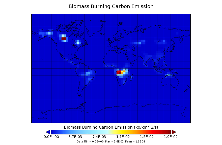
Carbon Monitoring System Carbon Flux for Fire L4 V1 (CMSFluxFire) at GES DISC
National Aeronautics and Space Administration —
This dataset provides the Carbon Flux for Fires.The NASA Carbon Monitoring System (CMS) is designed to make significant contributions in characterizing, quantifying,... -
Federal
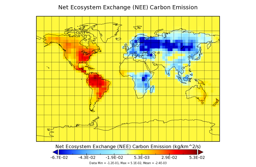
Carbon Monitoring System Flux from the Net Ecosystem Exchange L4 V1 (CMSFluxNEE) at GES DISC
National Aeronautics and Space Administration —
This dataset provides the Carbon Flux from the Net Ecosystem Exchange.The NASA Carbon Monitoring System (CMS) is designed to make significant contributions in... -
Federal
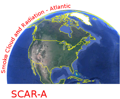
CAR SCAR-A Sulfates, Clouds, and Radiation-Atlantic L1 V1 (CAR_SCARA_L1C) at GES DISC
National Aeronautics and Space Administration —
The objectives for the SCAR mission are to advance our knowledge of how the physical, chemical and radiative processes in our atmosphere are affected by sulfate...

Official websites use .gov
A
.gov website belongs to an official government
organization in the United States.
Secure .gov websites use HTTPS
A
lock (
) or https:// means you’ve safely connected to
the .gov website. Share sensitive information only on official,
secure websites.