
-
Federal
TRACE-A Brazil Data
National Aeronautics and Space Administration —
TRACE-A_Brazil_Data is the aircraft and rawinsonde data collected in Brazil during the Transport and Atmospheric Chemistry near the Equator - Atlantic (TRACE-A)... -
Federal
NAMMA CARBON MONOXIDE BY ATTENUATED LASER TRANSMISSION (COBALT) V1
National Aeronautics and Space Administration —
The NAMMA Carbon mOnoxide By Attenuated Laser Transmission (COBALT) dataset includes measurements of the carbon monoxide mixing ratio and derived carbon monoxide... -
Federal
SAFARI 2000 MODIS 500-m Burned Area Products, Southern Africa, Dry Season 2000
National Aeronautics and Space Administration —
The SAFARI 2000 project was selected as the first regional test for a prototype regional 500 m MODIS burned area product. The MODIS burned area product maps the 500 m... -
Federal
SAFARI 2000 TOVS Surface and Atmospheric Parameters, 1-Deg, 1999-2001
National Aeronautics and Space Administration —
NOAA's TIROS (Television Infrared Observation Satellite) Operational Vertical Sounder (TOVS) is a suite of three sensors: the Microwave Sounding Unit (MSU), the High... -
Federal
BioSCape: BioSoundSCape Acoustic Recordings, South Africa, 2023
National Aeronautics and Space Administration —
This dataset holds in situ sound recordings from sites in Greater Cape Floristic Region (GCFR), South Africa from June to December 2023. The recordings were collected... -
Federal
TRACE-A Supplementary Satellite Data
National Aeronautics and Space Administration —
TRACE-A_Satellite_Data is the supplementary satellite data collected during the Transport and Atmospheric Chemistry near the Equator - Atlantic (TRACE-A) suborbital... -
Federal
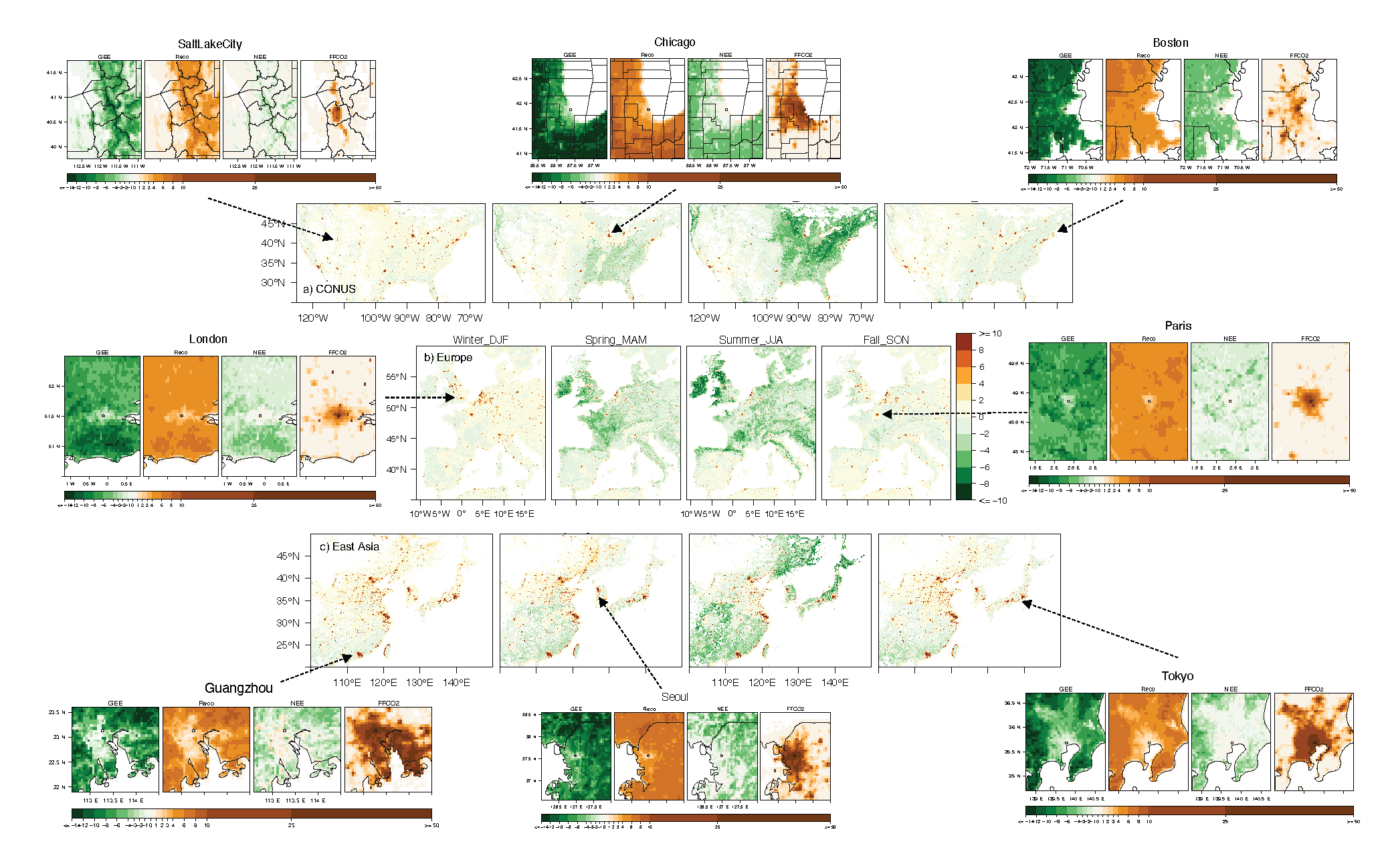
Urban Biogenic CO2 fluxes: GPP, Reco and NEE Estimates from SMUrF, 2010-2019
National Aeronautics and Space Administration —
This dataset contains estimates of biogenic CO2 flux components at 0.05 degree resolution from the Solar-Induced Fluorescence (SIF) for Modeling Urban biogenic Fluxes... -
Federal
TRACE-A Balloonsondes and Ozonesondes Data
National Aeronautics and Space Administration —
TRACE-A_Sondes_Data is the balloonsonde and ozonesonde data collected during the Transport and Atmospheric Chemistry near the Equator - Atlantic (TRACE-A) suborbital... -
Federal
Measurement of Air Pollution from Satellites (MAPS) Space Radar Laboratory - 2 (SRL2) Carbon Monoxide Second by Second data
National Aeronautics and Space Administration —
MAPS Overview The MAPS experiment measures the global distribution of carbon monoxide (CO) mixing ratios in the free troposphere. Because of MAPS' previous flights on... -
Federal
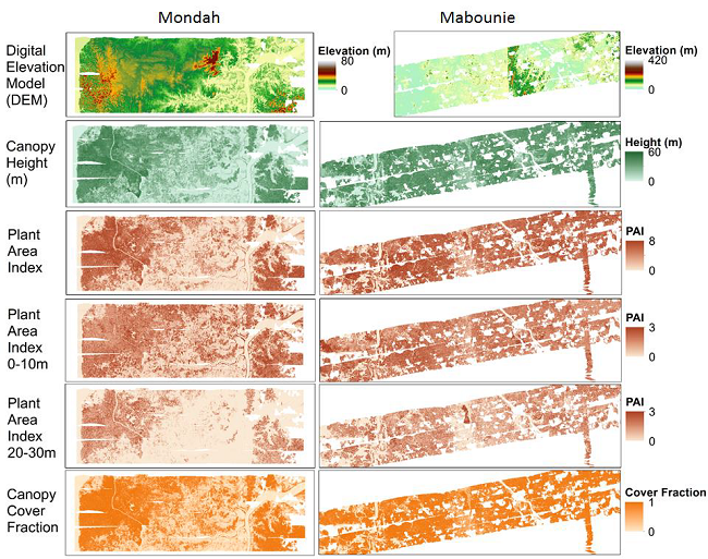
AfriSAR: Gridded Forest Biomass and Canopy Metrics Derived from LVIS, Gabon, 2016
National Aeronautics and Space Administration —
This dataset contains gridded forest characterization products derived from full-waveform lidar data acquired by NASA's airborne Land, Vegetation, and Ice Sensor... -
Federal
SAFARI 2000 Landscape Photographs of Kalahari Transect, Mongu, Skukuza Sites
National Aeronautics and Space Administration —
This data set contains Global Positioning System (GPS) imprinted landscape photographs at 100 m intervals along the Large Grid Transects at Kalahari Transect sites in... -
Federal
SAFARI 2000 Historical Fire Maps, Kruger National Park, 1992-2001
National Aeronautics and Space Administration —
Kruger National Park (KNP) was established in 1898 to protect wildlife on nearly 2 million hectares of the South African Lowveld. The climate in this region of South... -
Federal
TRACE-A DC-8 In-Situ Trace Gas Data
National Aeronautics and Space Administration —
TRACE-A_TraceGas_AircraftInSitu_DC8_Data is the in-situ trace gas data collected onboard the DC-8 aircraft during the Transport and Atmospheric Chemistry near the... -
Federal
SAFARI 2000 Modeled Fuel Load in Southern Africa, 1999-2000
National Aeronautics and Space Administration —
This data set contains global, spatially explicit (1 km2 grid cells) and temporally explicit (semi-monthly) modeled output of fuel loads over southern Africa. The... -
Federal
SAFARI 2000 Derived Soil Properties, 0.5-Deg (ISRIC-WISE)
National Aeronautics and Space Administration —
The data set consists of a southern Africa subset of the ISRIC-WISE global data set of derived soil properties. The World Inventory of Soil Emission Potentials (WISE)... -
Federal
SAFARI 2000 1-Degree Estimates of Burned Biomass, Area, and Emissions, 2000
National Aeronautics and Space Administration —
A new method is used to generate spatial estimates of monthly averaged biomass burned area and spatial and temporal estimates of trace gas and aerosol emissions from... -
Federal
CMS: Mangrove Canopy Height Estimates from Remote Imagery, Zambezi Delta, Mozambique
National Aeronautics and Space Administration —
This data set provides high resolution canopy height estimates for mangrove forests in the Zambezi Delta, Mozambique, Africa. The estimates were derived from three... -
Federal
SAFARI 2000 Fire Emission Data, Dry Season 2000
National Aeronautics and Space Administration —
As part of the Southern Africa Regional Science Initiative (SAFARI 2000), the University of Montana participated in both ground-based and airborne campaigns during... -
Federal
TRACE-A DC-8 Remotely Sensed Differential Absorption Lidar (DIAL) Data
National Aeronautics and Space Administration —
TRACE-A_AircraftRemoteSensing_DC8_DIAL_Data is the remotely sensed Differential Absorption Lidar (DIAL) data collected onboard the DC-8 aircraft during the Transport... -
Federal
NAMMA MODIS/AQUA AND MODIS/TERRA DEEP BLUE PRODUCTS V1
National Aeronautics and Space Administration —
The NAMMA MODIS/AQUA and MODIS/TERRA Deep Blue Products dataset is a collection of images depicting the aerosol optical depth derived from the MODIS deep blue...

Official websites use .gov
A
.gov website belongs to an official government
organization in the United States.
Secure .gov websites use HTTPS
A
lock (
) or https:// means you’ve safely connected to
the .gov website. Share sensitive information only on official,
secure websites.