

36 datasets found for "400多款微信公众号朋友圈小游戏源码合集 全部手机平板自适应+HTML5✅项目合作 二开均可 TG:saolei44✅.rhxWxSTNcJMDp"
-
Federal
Tree Canopy Cover for the Circumpolar Taiga-Tundra Ecotone: 2000-2005
National Aeronautics and Space Administration —
This data set provides a map of selected areas with defined tree canopy cover over the circumpolar taiga-tundra ecotone (TTE). Canopy cover was derived from the... -
Federal
Global Vegetation Types, 1971-1982 (Matthews)
National Aeronautics and Space Administration —
The global vegetation type data of 1 x 1 degree latitude and longitude resolution were designed for use in studies of climate and climate change. Vegetation data were... -
Federal
MODIS/Terra Near Real Time (NRT) Aerosol 5-Min L2 Swath 3km
National Aeronautics and Space Administration —
The MODIS level-2 atmospheric aerosol product provides retrieved ambient aerosol optical properties (e.g., optical thickness and size distribution), mass... -
Federal
NARSTO EPA Supersite (SS) Houston, Texas Air Quality Study 2000 (TexAQS2000) Formaldehyde and Hydrogen Peroxide Data
National Aeronautics and Space Administration —
NARSTO_EPA_SS_HOUSTON_TEXAQS2000_PM_SIZE_MASS is North American Research Strategy for Tropospheric Ozone (NARSTO) Environmental Protection Agency (EPA) Supersite (SS)... -
Federal
INTEX-A AIRMAP data
National Aeronautics and Space Administration —
Intercontinental Chemical Transport Experiment - North America Phase A (INTEX-A) is an integrated atmospheric field experiment performed over North America. The study... -
Federal
Satellite Atmos. Correction Coef. (FIFE)
National Aeronautics and Space Administration —
The atmospheric effects on the transmitted and reflected solar radiation should be factored into the estimation of geophysical and biophysical parameters from... -
Federal
SAFARI 2000 SeaWiFS Images for Core Study Sites, 2000-2001
National Aeronautics and Space Administration —
This data set contains Sea-viewing Wide Field-of-view Sensor (SeaWiFS) imagery for the eight core study sites of Mongu, Etosha, Kasangu, Skukuza, Mutoko, Mzola,... -
Federal
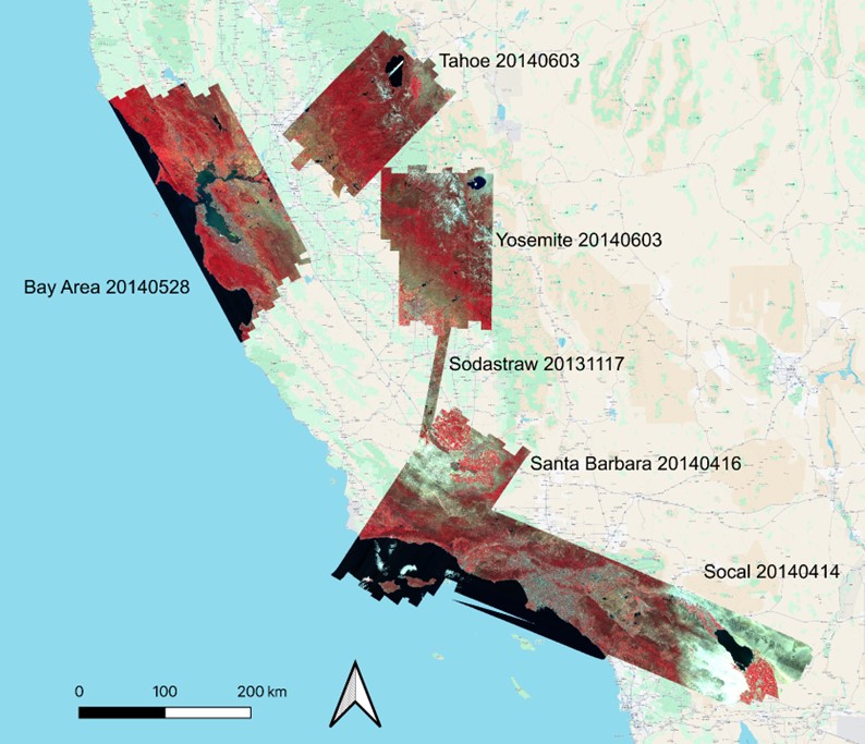
WDTS: AVIRIS-Classic L2B Corrected and Georectified Surface Reflectance, 2013-2018
National Aeronautics and Space Administration —
This dataset includes Level-2 (L2) surface reflectance imagery from the AVIRIS-Classic instrument collected for NASA's Western Diversity Time Series Project over... -
Federal
Berkeley Extreme and Far-UV Spectrometer
National Aeronautics and Space Administration —
The Berkeley Extreme and Far-UV Spectrometer (BEFS), flew on the Orbiting and Retrievable Far and Extreme Ultraviolet Spectrograph (ORFEUS)-SPAS I and II space... -
Federal
EUVE Right Angle Program, 2nd Catalog
National Aeronautics and Space Administration —
The Second Extreme Ultraviolet Explorer (EUVE) Right Angle Program (RAP) Catalog contains information on the detection of 235 extreme ultraviolet (EUV) sources, of... -
Federal
HOPS SED Fits Catalog
National Aeronautics and Space Administration —
The Herschel Orion Protostar Survey (HOPS, KPOT_tmegeath_2) is a sample of 410 young stellar objects (YSOs) in the Orion molecular clouds, selected from Spitzer data.... -
Federal
EUVE Right Angle Program, 3rd Catalog
National Aeronautics and Space Administration —
The Third Extreme Ultraviolet Explorer (EUVE) Right Angle Program (RAP) Catalog contains information on the detection of 76 extreme ultraviolet (EUV) sources, of... -
Federal
Hubble Ultra Deep Field Catalog
National Aeronautics and Space Administration —
The Hubble Ultra Deep Field (UDF, Principle Investigator: Steven V. W. Beckwith) is a 400-orbit Hubble Space Telescope (HST) Cycle 12 program to image a single field... -
Federal
AVIRIS-Classic: L1B Calibrated Radiance, Facility Instrument Collection, V1
National Aeronautics and Space Administration —
This dataset contains Level 1B (L1B) orthocorrected, scaled radiance image files as well as files of observational geometry and illumination parameters and supporting...
36 datasets found for "400多款微信公众号朋友圈小游戏源码合集 全部手机平板自适应+HTML5✅项目合作 二开均可 TG:saolei44✅.rhxWxSTNcJMDp"