
-
Federal
BOREAS TF-10 NSA-YJP Tower Flux, Meteorological, and Porometry Data
National Aeronautics and Space Administration —
The BOREAS TF-10 team collected tower flux and meteorological data at two sites, a fen and a young jack pine forest, near Thompson, Manitoba, Canada, as part of... -
Federal
Surface Radiance Data: UNL (FIFE)
National Aeronautics and Space Administration —
The Surface Temperatures, Reflected and Emitted Radiation, and PAR from UNL Data Set contains surface temperatures at different view zenith and azimuth angles, net... -
Federal
High Resolution Global Contiguous SIF Estimates from OCO-2 SIF and MODIS, Version 2
National Aeronautics and Space Administration —
This dataset provides spatially-contiguous global mean daily solar-induced chlorophyll fluorescence (SIF) estimates at 0.05 degree (approximately 5 km at the equator)... -
Federal
Global Vegetation Height Metrics from GEDI and ICESat2
National Aeronautics and Space Administration —
This dataset provides global rasters of relative height metrics for vegetation from Global Ecosystem Dynamics Investigation (GEDI) L2A data and Ice, Cloud, and Land... -
Federal
ISLSCP II University of Maryland Global Land Cover Classifications, 1992-1993
National Aeronautics and Space Administration —
The objective of the International Satellite Land Surface Climatology Project (ISLSCP II) study that produced this data set, ISLSCP II University of Maryland Global... -
Federal
NACP Site: Terrestrial Biosphere Model and Aggregated Flux Data in Standard Format
National Aeronautics and Space Administration —
This data set provides standardized output variables for gross primary productivity (GPP), net ecosystem exchange (NEE), leaf area index (LAI), ecosystem respiration... -
Federal
NACP Integrated Wildland and Cropland 30-m Fuel Characteristics Map, U.S.A., 2010
National Aeronautics and Space Administration —
The data set provides a 30-m comprehensive fuelbed characteristics map for both the wildland and cropland areas of the conterminous United States (CONUS) for 2010.... -
Federal
Land Cover and Land Use Classification for the State of New Hampshire, 1996-2001
National Aeronautics and Space Administration —
The New Hampshire Geographically Referenced Analysis and Information Transfer System (GRANIT) land cover data set provides a land cover and land use product at 30-m... -
Federal
CMS: LiDAR Data for Mangrove Forests in the Zambezi River Delta, Mozambique, 2014
National Aeronautics and Space Administration —
This data set provides high-resolution LiDAR point cloud data collected during surveys over mangrove forests in the Zambezi River Delta in Mozambique in May 2014. The... -
Federal
NWS Daily Climatology Data: 1990 (SNF)
National Aeronautics and Space Administration —
Weather data were collected by the National Weather Service in International Falls, Minnesota. International Falls is about 80 miles from the SNF, but the weather... -
Federal
NPP Grassland: Shortandy, Kazakhstan, 1977-1980, R1
National Aeronautics and Space Administration —
This data set provides two data files in text format (.txt). One file contains biomass measurements and cumulative ANPP calculations made between 1977 and 1980 on a... -
Federal
ATom: CO2, CH4, and CO Measurements from Picarro, 2016-2018
National Aeronautics and Space Administration —
This dataset contains atmospheric measurements of CO2, CH4, and CO mixing ratios made with a Picarro G2401 spectrometer during the four ATom campaigns. Picarro G2401... -
Federal
Global Maps of Atmospheric Nitrogen Deposition, 1860, 1993, and 2050
National Aeronautics and Space Administration —
This data set provides global gridded estimates of atmospheric deposition of total inorganic nitrogen (N), NHx (NH3 and NH4+), and NOy (all oxidized forms of nitrogen... -
Federal
GEDI L4A Footprint Level Aboveground Biomass Density, Version 2.1
National Aeronautics and Space Administration —
This dataset contains Global Ecosystem Dynamics Investigation (GEDI) Level 4A (L4A) Version 2 predictions of the aboveground biomass density (AGBD; in Mg/ha) and... -
Federal
Decadal Land Use and Land Cover Classifications across India, 1985, 1995, 2005
National Aeronautics and Space Administration —
This data set provides land use and land cover (LULC) classification products at 100-m resolution for India at decadal intervals for 1985, 1995 and 2005. The data... -
Federal
LiDAR Derived Biomass, Canopy Height, and Cover for New England Region, USA, 2015
National Aeronautics and Space Administration —
This dataset provides 30 m gridded estimates of aboveground biomass density (AGBD), forest canopy height, and tree canopy coverage for the New England Region of the... -
Federal
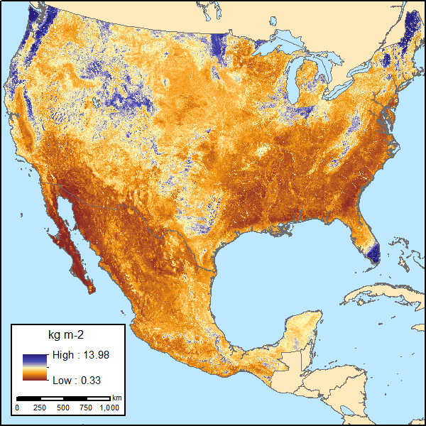
Soil Organic Carbon Estimates for 30-cm Depth, Mexico and Conterminous USA, 1991-2011
National Aeronautics and Space Administration —
This dataset provides two sets of gridded estimates of estimated soil organic carbon (SOC) and associated uncertainties for 0-30 cm topsoil layer in kg SOC/m2 at... -
Federal
LiDAR Surveys over Selected Forest Research Sites, Brazilian Amazon, 2008-2018
National Aeronautics and Space Administration —
This dataset provides the complete catalog of point cloud data collected during LiDAR surveys over selected forest research sites across the Amazon rainforest in... -
Federal
Forest Inventory and Biophysical Measurements, Brazilian Amazon, 2009-2018
National Aeronautics and Space Administration —
This dataset provides the complete catalog of forest inventory and biophysical measurements collected over selected forest research sites across the Amazon rainforest...

Official websites use .gov
A
.gov website belongs to an official government
organization in the United States.
Secure .gov websites use HTTPS
A
lock (
) or https:// means you’ve safely connected to
the .gov website. Share sensitive information only on official,
secure websites.