
-
Federal
LiDAR Derived Biomass, Canopy Height, and Cover for New England Region, USA, 2015
National Aeronautics and Space Administration —
This dataset provides 30 m gridded estimates of aboveground biomass density (AGBD), forest canopy height, and tree canopy coverage for the New England Region of the... -
Federal
ATom: In Situ Data from Caltech Chemical Ionization Mass Spectrometer (CIT-CIMS), V2
National Aeronautics and Space Administration —
This dataset provides the concentrations of gas-phase organic and inorganic analytes measured by the California Institute of Technology (CIT) Chemical Ionization Mass... -
Federal
LBA-ECO CD-06 Carbon Cycling in Rivers in Amazonas and Acre, Brazil: 2005-2006
National Aeronautics and Space Administration —
This data set provides measured and calculated variables describing the carbon pools in river waters, CO2 respired from the water and total amount of CO2 evaded,... -
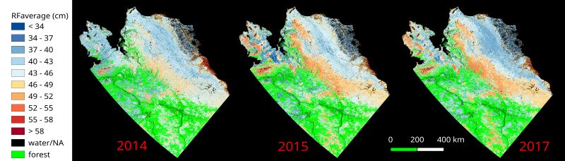
Federal
ABoVE: Upscaled Active Layer Thickness in Northern Alaska, 2014-2017
National Aeronautics and Space Administration —
The dataset consists of maps of estimated Active Layer Thickness (ALT) at 30-m resolution throughout the northern half of Alaska for the years 2014, 2015, and 2017.... -
Federal
ATom: CO2, CH4, and CO Measurements from Picarro, 2016-2018
National Aeronautics and Space Administration —
This dataset contains atmospheric measurements of CO2, CH4, and CO mixing ratios made with a Picarro G2401 spectrometer during the four ATom campaigns. Picarro G2401... -
Federal
BOREAS RSS-02 Extracted Reflectance Factors Derived from ASAS Imagery
National Aeronautics and Space Administration —
Atmospherically-corrected bidirectional reflectance factor means for small homogeneous areas from several BOREAS sites were derived from multi-spectral, multi-angle... -
Federal
BOREAS RSS-01 PARABOLA SSA Surface Reflectance and Transmittance Data
National Aeronautics and Space Administration —
The BOREAS RSS-01 team collected surface reflectance and transmittance data from three forested sites in the SSA. This data set contains averaged reflectance factors... -
Federal
MASTER: California Fires, California, November 2007
National Aeronautics and Space Administration —
This dataset includes Level 1B (L1B) data products from the MODIS/ASTER Airborne Simulator (MASTER) instrument. The spectral data were collected during six flights... -
Federal
BOREAS HYD-03 Subcanopy Meteorological Data
National Aeronautics and Space Administration —
The BOREAS HYD-03 team collected several data sets related to the hydrology of forested areas. This data set includes measurements of wind speed and direction; air... -
Federal
LBA-ECO CD-06 Ji-Parana River Basin Land Use and Land Cover Map, Brazil: 1999
National Aeronautics and Space Administration —
This data set provides a land use/land cover map of the Ji-Parana River Basin in the state of Rondonia, Brazil produced from the digital classification of eight... -
Federal
BOREAS TGB-04 NSA-BVP Tower Flux and Meteorological Data
National Aeronautics and Space Administration —
The BOREAS TGB-04 team measured the exchange of heat, water, and CO2 between a boreal forest beaver pond and the atmosphere in the NSA for the ice-free period of... -
Federal
ISLSCP II Globalview: Atmospheric CO2 Concentrations
National Aeronautics and Space Administration —
The GlobalView Carbon Dioxide (CO2) data product contains synchronized and smoothed time series of atmospheric CO2 concentrations at selected sites that were created... -
Federal
LBA-ECO ND-07 Carbon and Nitrogen in Cerrado Plants and Soils, Brasilia: 1999-2000
National Aeronautics and Space Administration —
This data set provides (1) delta 15N ratios and nitrogen concentrations for foliar samples and (2) delta 13C and delta 15N ratios as well as carbon and nitrogen... -
Federal
Daily Rainfall Data (FIFE)
National Aeronautics and Space Administration —
The FIFE Daily Rainfall Data Set contains daily precipitation values for 42 rain gauge stations within the Konza LTER portion of the FIFE site (i.e., Northwest... -
Federal
BOREAS TGB-07 Dry Deposition Herbicide and Organochlorine Flux Data
National Aeronautics and Space Administration —
The BOREAS TGB-07 team measured the concentration and flux of several agricultural pesticides in air, rainwater, and dry deposition samples in order to determine the... -
Federal
ACT-America: Profile-based Planetary Boundary Layer Heights, Eastern USA
National Aeronautics and Space Administration —
This dataset provides profile-based estimates of the height to the top of the planetary boundary layer (PBL), also known as the atmospheric boundary layer (ABL), in... -
Federal
LBA-ECO LC-08 Passive Ground-based Fire Data, Para and Mato Grosso Brazil: 2001-2002
National Aeronautics and Space Administration —
This data set reports observations of fires in the vicinity of Maraba, Para, Brazil, from November 3-5th, 2001, and in Mato Grosso, Brazil, between Cuiaba and Alta... -
Federal
NACP Aboveground Biomass and Carbon Baseline Data, V.2 (NBCD 2000), U.S.A., 2000
National Aeronautics and Space Administration —
The NBCD 2000 (National Biomass and Carbon Dataset for the Year 2000) data set provides a high-resolution (30 m) map of year-2000 baseline estimates of basal area-...

Official websites use .gov
A
.gov website belongs to an official government
organization in the United States.
Secure .gov websites use HTTPS
A
lock (
) or https:// means you’ve safely connected to
the .gov website. Share sensitive information only on official,
secure websites.