
-
Federal
ABoVE: Landsat-derived Burn Scar dNBR across Alaska and Canada, 1985-2015
National Aeronautics and Space Administration —
This dataset contains differenced Normalized Burned Ratio (dNBR) at 30-m resolution calculated for burn scars from fires that occurred within the Arctic Boreal and... -
Federal
Distribution of Estimated Stand Age Across Siberian Larch Forests, 1989-2012
National Aeronautics and Space Administration —
This data set provides mapped estimates of the stand age of young (less than 25 years old) larch forests across Siberia from 1989-2012 at 30-m resolution. The age... -
Federal
GEDI L4A Footprint Level Aboveground Biomass Density, Version 2.1
National Aeronautics and Space Administration —
This dataset contains Global Ecosystem Dynamics Investigation (GEDI) Level 4A (L4A) Version 2 predictions of the aboveground biomass density (AGBD; in Mg/ha) and... -
Federal
LBA-ECO ND-30 Nutrient Analysis and Gas Fluxes, Forest Chronosequences, Para, Brazil
National Aeronautics and Space Administration —
This data set provides fine litterfall mass and nutrient concentrations from samples collected at chronosequences established at Sao Francisco do Para and Capitao... -
Federal
Global Fire Atlas with Characteristics of Individual Fires, 2003-2016
National Aeronautics and Space Administration —
The Global Fire Atlas is a global dataset that tracks the day-to-day dynamics of individual fires to determine the timing and location of ignitions, fire size,... -
Federal
Geoecology: County-Level Environmental Data for the United States, 1941-1981
National Aeronautics and Space Administration —
The Geoecology database is a compilation of environmental data for the period 1941 to 1981. The Geoecology database contains selected data on terrain and soils, water... -
Federal
Ecosystem Functional Type Distribution Map for the Conterminous USA, 2001-2014
National Aeronautics and Space Administration —
This dataset provides maps of the distribution of ecosystem functional types (EFTs) and the interannual variability of EFTs at 0.05 degree resolution across the... -
Federal
BioSCape Vegetation Surveys Berg and Eerste River Catchments, South Africa, 2022-2023
National Aeronautics and Space Administration —
This dataset contains vegetation plot survey data collected at 36 sites across the Berg and Eerste River catchments in the Western Cape, South Africa collected during... -
Federal
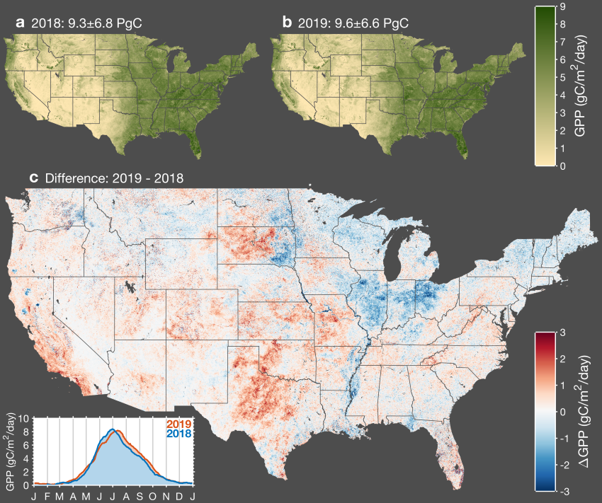
CMS: Daily Gross Primary Productivity over CONUS from TROPOMI SIF, 2018-2021
National Aeronautics and Space Administration —
This dataset includes estimates of gross primary production (GPP) for the conterminous U.S., for 2018-02-15 to 2021-10-15, based on measurements of solar-induced... -
Federal
SAFARI 2000 Biomass Burning Emissions, Selected Sites, Dry Season 2000
National Aeronautics and Space Administration —
Biomass burning is a major source for gaseous and particulate atmospheric pollution over southern Africa and globally. The purpose of this study was to quantify... -
Federal
NACP Aboveground Biomass and Carbon Baseline Data, V.2 (NBCD 2000), U.S.A., 2000
National Aeronautics and Space Administration —
The NBCD 2000 (National Biomass and Carbon Dataset for the Year 2000) data set provides a high-resolution (30 m) map of year-2000 baseline estimates of basal area-... -
Federal
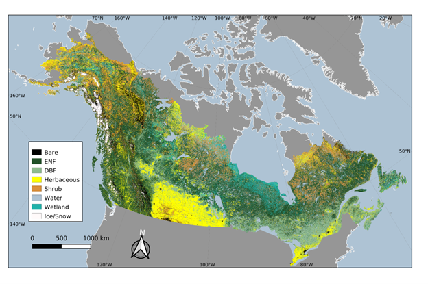
ABoVE: Landsat-derived Annual Dominant Land Cover in Boreal North America, 1986-2020
National Aeronautics and Space Administration —
This dataset contains a 30-m resolution time series of annual land cover classifications as the dominant plant functional type class for all of boreal Alaska and... -
Federal
NACP North American 8-km Net Ecosystem Exchange and Component Fluxes, 2004
National Aeronautics and Space Administration —
This data set provides modeled carbon flux estimates at 8-km spatial resolution over North America for the year 2004 of (1) net ecosystem exchange (NEE) of carbon... -
Federal
Wind Profile Data: LIDAR - NOAA (FIFE)
National Aeronautics and Space Administration —
The aim of this wind profile study was to derive wind profiles and momentum fluxes from the National Oceanic and Atmospheric Administration (NOAA)/Wave Propagation... -
Federal
PnET Models: Carbon, Nitrogen, Water Dynamics in Forest Ecosystems (Vers. 4 and 5)
National Aeronautics and Space Administration —
PnET (Photosynthetic / EvapoTranspiration model) is a nested series of models of carbon, water, and nitrogen dynamics in forest ecosystems. The models can be used to... -
Federal
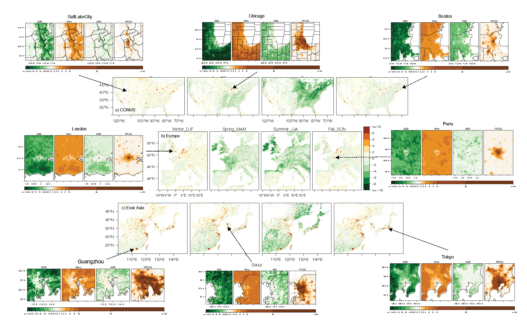
Urban Biogenic CO2 fluxes: GPP, Reco and NEE Estimates from SMUrF, 2010-2019
National Aeronautics and Space Administration —
This dataset contains estimates of biogenic CO2 flux components at 0.05 degree resolution from the Solar-Induced Fluorescence (SIF) for Modeling Urban biogenic Fluxes... -
Federal
Timeseries of Arctic-Boreal Lake Area Derived from CubeSat Imagery, 2017
National Aeronautics and Space Administration —
This dataset provides near-daily lake area timeseries for 85,358 lakes across four study areas in Northern Canada and Alaska, USA, between May 1 and October 1, 2017.... -
Federal
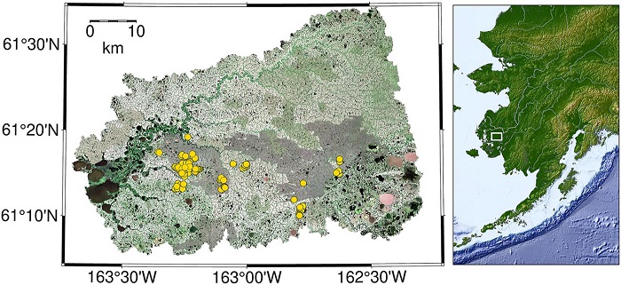
CO2 and CH4 Fluxes from Waterbodies, Yukon-Kuskokwim Delta, Alaska, 2016-2019
National Aeronautics and Space Administration —
This dataset provides estimates of carbon dioxide (CO2) and methane (CH4) diffusive fluxes from waterbodies, and watershed landcover data for the central-interior of...

Official websites use .gov
A
.gov website belongs to an official government
organization in the United States.
Secure .gov websites use HTTPS
A
lock (
) or https:// means you’ve safely connected to
the .gov website. Share sensitive information only on official,
secure websites.