
-
Federal
SAFARI 2000 Surface Atmospheric Radiative Transfer (SMART), Dry Season 2000
National Aeronautics and Space Administration —
Surface-sensing Measurements for Radiative Transfer (SMART) and Chemical, Optical, and Microphysical Measurements of In-situ Troposphere (COMMIT) consist of a suite... -
Federal
Global Forest Ecosystem Structure and Function Data For Carbon Balance Research
National Aeronautics and Space Administration —
A comprehensive global database has been assembled to quantify CO2 fluxes and pathways across different levels of integration (from photosynthesis up to net ecosystem... -
Federal
Aircraft Flux-Raw: Univ. Col. (FIFE)
National Aeronautics and Space Administration —
The NCAR King Air participation in FIFE-1987 and FIFE-1989 was part of a coordinated atmospheric boundary layer component which included other aircraft, surface... -
Federal
LBA Regional Derived Soil Properties, 0.5-Deg (ISRIC-WISE)
National Aeronautics and Space Administration —
The data set consists of a subset of the ISRIC-WISE global data set of derived soil properties for the study area of the Large Scale Biosphere-Atmosphere Experiment... -
Federal
VEMAP 2: Monthly Ecosystem Model Responses to U.S. Climate Change, 1994-2100
National Aeronautics and Space Administration —
The Vegetation-Ecosystem Modeling and Analysis Project (VEMAP) was a large, collaborative, multi-institutional, international effort whose goal was to evaluate the... -
Federal
SAFARI 2000 AERONET Ground-based Aerosol Data, Dry Season 2000
National Aeronautics and Space Administration —
AERONET (AErosol RObotic NETwork) is an optical ground-based aerosol monitoring network and data archive system. AERONET measurements of the column-integrated aerosol... -
Federal
SAFARI 2000 ETA Atmospheric Model Data, Wet and Dry Seasons 2000
National Aeronautics and Space Administration —
With modern computer power now capable of making mesoscale model output available in real time in the operational environment, increased attention has been given to... -
Federal
SAFARI 2000 AOT and Column Water Vapor, Kalahari Transect, Wet Season 2000
National Aeronautics and Space Administration —
The data presented here include the aerosol optical thickness (AOT) and column water vapor measurements taken at sites along the Kalahari Transect using a Microtops... -
Federal
SAFARI 2000 Meteorological and Flux Tower Measurements in Maun, Botswana, 2000
National Aeronautics and Space Administration —
To investigate potential contributions of savanna ecosystems to the Earth s carbon balance, an eddy covariance system was used to measure the seasonal variation in... -
Federal
SAFARI 2000 AVHRR-derived Land Surface Temperature Maps, Africa, 1995-2000
National Aeronautics and Space Administration —
Land Surface Temperature (LST) is a key indicator of land surface states, and can provide information on surface-atmosphere heat and mass fluxes, vegetation water... -
Federal
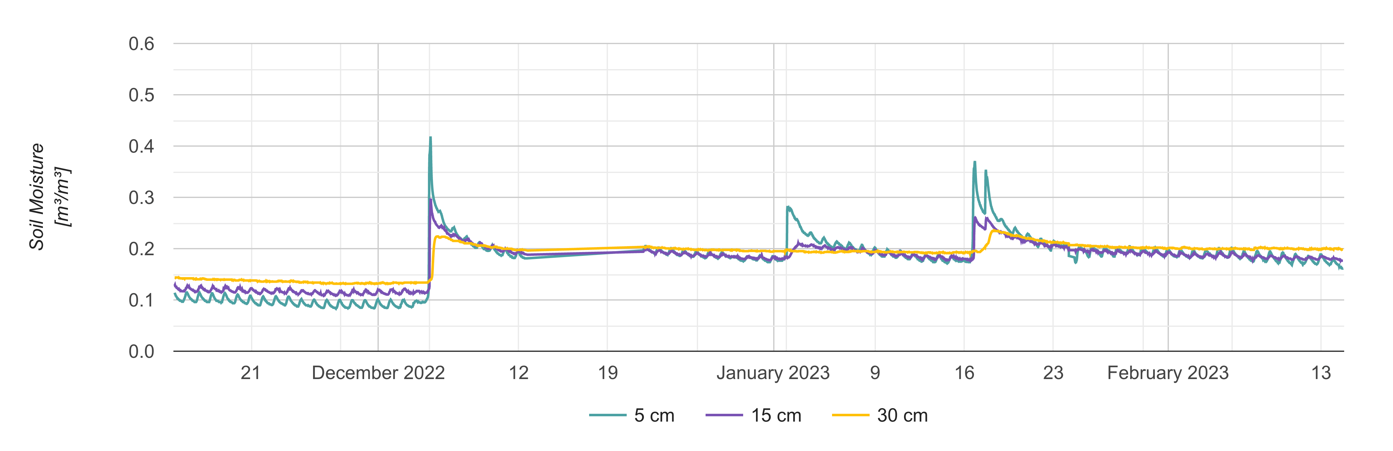
Soil Moisture Profiles and Temperature Data from SoilSCAPE Sites, Version 2
National Aeronautics and Space Administration —
This dataset contains in-situ soil moisture profile and soil temperature data collected at 30-minute intervals at SoilSCAPE (Soil moisture Sensing Controller and... -
Federal
NOAA Regional Surface Data (FIFE)
National Aeronautics and Space Administration —
The FIFE Staff Science effort included the acquisition, processing and archiving of meteorological parameters of the atmosphere above the FIFE study area, which would... -
Federal
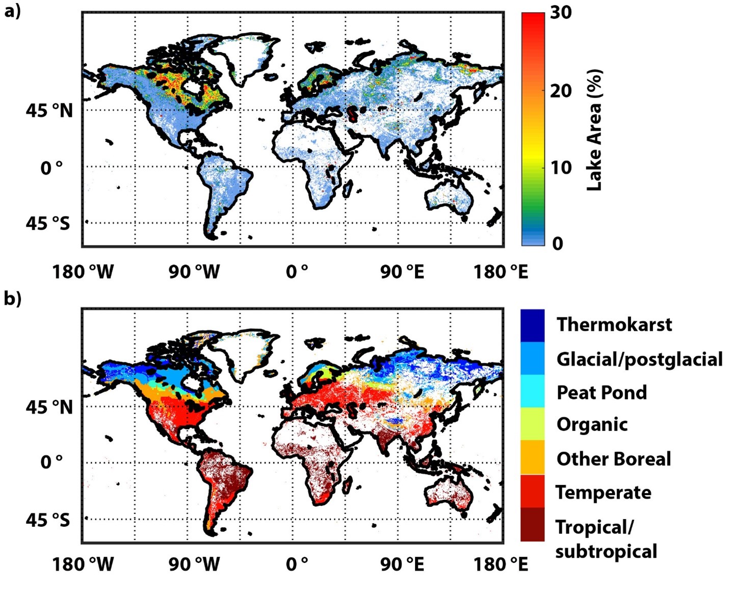
Global-Gridded Daily Methane Emissions Climatology from Lake Systems, 2003-2015
National Aeronautics and Space Administration —
This dataset provides global gridded information on lake surface area and open water CH4 emissions at a resolution of 0.25-degree x 0.25-degree for an annual... -
Federal
Characteristics of African Savanna Biomes for Determining Woody Cover
National Aeronautics and Space Administration —
This data set includes the soil and vegetation characteristics, herbivore estimates, and precipitation measurement data for the 854 sites described and analyzed in... -
Federal
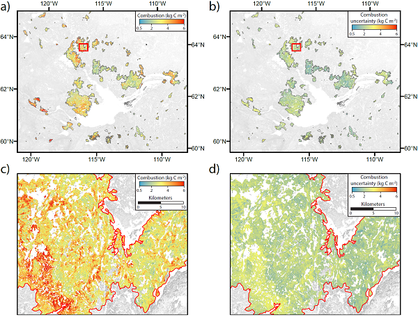
ABoVE: Wildfire Carbon Emissions and Burned Plot Characteristics, NWT, CA, 2014-2016
National Aeronautics and Space Administration —
This dataset provides estimates of wildfire carbon emissions and uncertainties at 30-m resolution, and measurements collected at burned and unburned field plots from... -
Federal
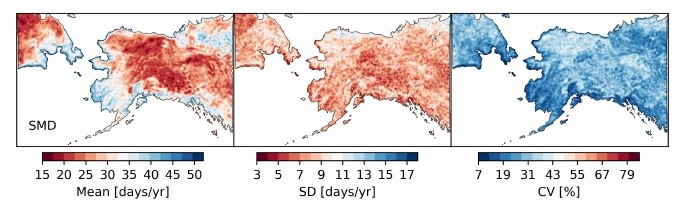
ABoVE: Passive Microwave-derived Annual Snow Melt Duration Date Maps, 1988-2018
National Aeronautics and Space Administration —
This dataset provides the annual period of snowpack melting (i.e., snow melt duration, SMD) across northwest Canada; Alaska, U.S.; and parts of far eastern Russia at... -
Federal
BOREAS RSS-18 Sunphotometer Data over the SSA
National Aeronautics and Space Administration —
The BOREAS RSS-18 team collected ground-based sunphotometer data in support of AVIRIS remote sensing activities at the SSA. The following information was compiled by... -
Federal
BOREAS TF-11 SSA Fen Soil Surface CO2 Flux Data
National Aeronautics and Space Administration —
The BOREAS TF-11 team gathered a variety of data to complement their tower flux measurements collected at the SSA Fen site. These data are soil surface CO2 flux data... -
Federal
BOREAS TE-10 Leaf Gas Exchange Data
National Aeronautics and Space Administration —
The BOREAS TE-10 team collected several data sets in support of its efforts to characterize and interpret information on the reflectance, transmittance, gas exchange,... -
Federal
Soil CO2 Flux Data (FIFE)
National Aeronautics and Space Administration —
In the Soil Carbon Dioxide Flux study, a prototype gas exchange system and sensor were used to determine the soil surface flux of CO2 and associated parameters at the...

Official websites use .gov
A
.gov website belongs to an official government
organization in the United States.
Secure .gov websites use HTTPS
A
lock (
) or https:// means you’ve safely connected to
the .gov website. Share sensitive information only on official,
secure websites.