
-
Federal
LBA Regional River Discharge Data (Coe and Olejniczak)
National Aeronautics and Space Administration —
This data set is a subset of a global river discharge data set by Coe and Olejniczak (1999). The subset was created for the study area of the Large Scale Biosphere-... -
Federal
LBA Regional Global Historical Climatology Network, V. 1, 1832-1990
National Aeronautics and Space Administration —
This data set consists of a subset of the Global Historical Climatology Network (GHCN) Version 1 database for the study area of the Large Scale Biosphere-Atmosphere... -
Federal
LBA-ECO LC-04 Macrohydrological Routing Data for the Amazon and Tocantins River Basin
National Aeronautics and Space Administration —
This data set provides continental-scale hydrological river flow routing parameter data for the Amazon and Tocantins River basins at 5 minute (~9 km) resolution... -
Federal
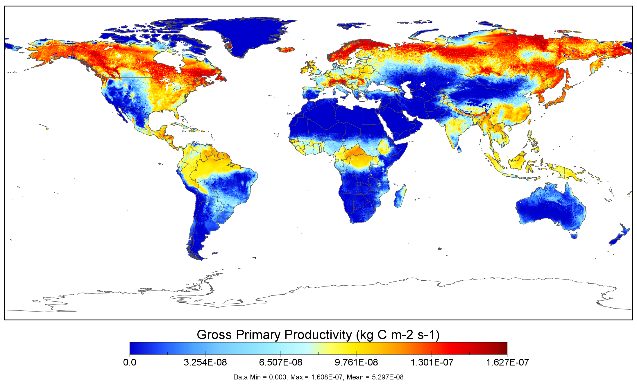
NACP MsTMIP: Global 0.5-degree Model Outputs in Standard Format, Version 1.0
National Aeronautics and Space Administration —
This data set provides global gridded estimates of carbon, energy, and hydrologic fluxes between the land and atmosphere from 15 Terrestrial Biosphere Models (TBMs)... -
Federal
LBA-ECO LC-07 CO2 and CH4 Flux from Wetlands, Negro River Basin, Brazil: 2004-2006
National Aeronautics and Space Administration —
This data set provides estimates of daily and monthly carbon dioxide (CO2) and methane (CH4) diffusive and ebullitive flux for dry and flooded areas from two study... -
Federal
LBA Regional Vegetation and Soils, 1-Degree (Wilson and Henderson-Sellers)
National Aeronautics and Space Administration —
This data set is a subset of a global vegetation and soils data set by Wilson and Henderson-Sellers (1985a). The subset was created for the study area of the Large... -
Federal
LBA Regional Derived Soil Properties, 0.5-Deg (ISRIC-WISE)
National Aeronautics and Space Administration —
The data set consists of a subset of the ISRIC-WISE global data set of derived soil properties for the study area of the Large Scale Biosphere-Atmosphere Experiment... -
Federal
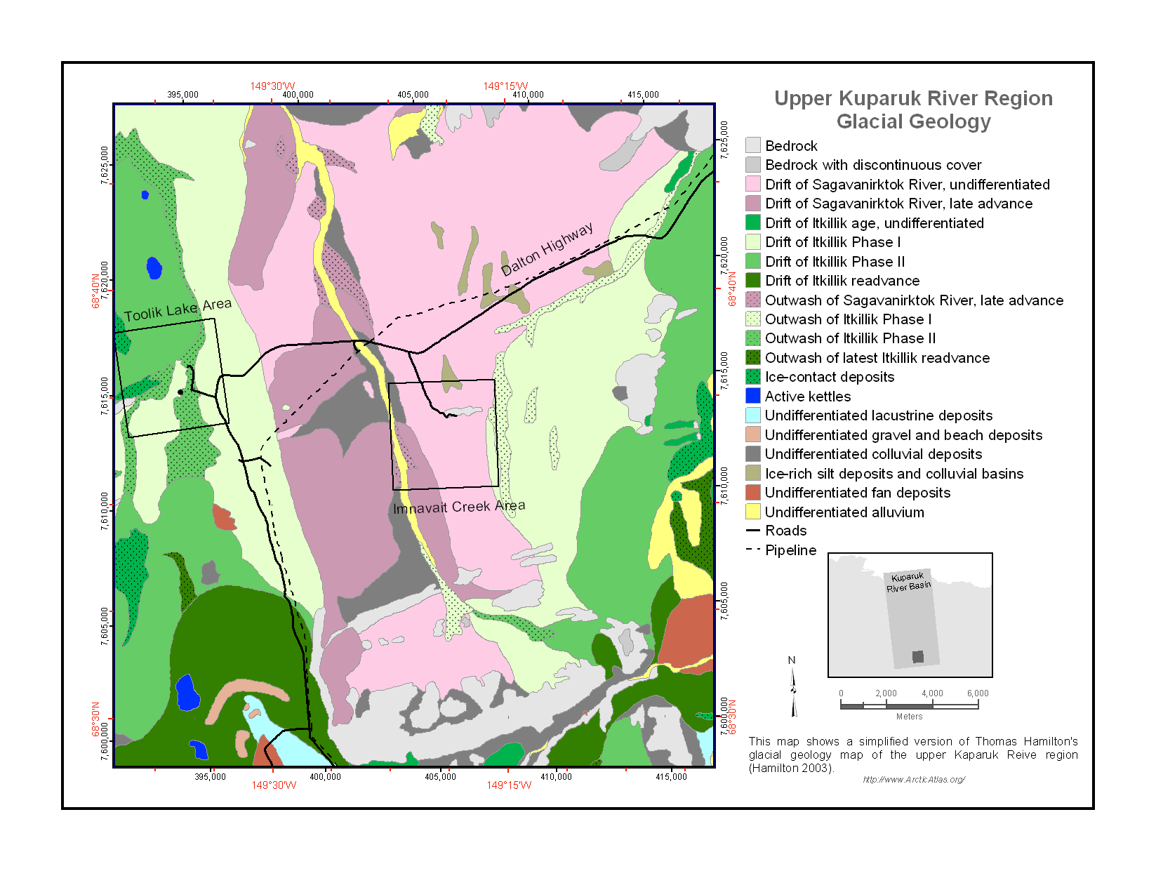
Maps of Vegetation Types and Physiographic Features, Kuparuk River Basin, Alaska
National Aeronautics and Space Administration —
This data set provides a collection of vegetation, landscape, geobotanical, elevation, hydrology, and geologic maps for the Kuparuk River Basin, North Slope, Alaska.... -
Federal
SAFARI 2000 Atmospheric Aerosol Measurements, Hand-held Hazemeters, Zambia
National Aeronautics and Space Administration —
Data presented in this database are the result of Hand Held 4-band Hazemeters and do not always satisfy to the high standards of quality associated with Automatic... -
Federal
SAFARI 2000 MODIS MOD05_L2 Water Vapor Data, Binary Format, for Southern Africa
National Aeronautics and Space Administration —
The Moderate Resolution Imaging Spectroradiometer (MODIS) precipitable water product consists of vertical column water-vapor amounts in centimeters (cm) at 1-km... -
Federal
Surface Water Elevation and Quality, Peace-Athabasca Delta, Canada, 2006-2007
National Aeronautics and Space Administration —
The Peace-Athabasca Delta (PAD) is a large boreal wetland located in northeastern Alberta, Canada at the confluence of the Peace and Athabasca Rivers with Lake... -
Federal
Ecosystem Demography Model: Scaling Vegetation Dynamics Across South America
National Aeronautics and Space Administration —
This model product contains the source code for the Ecosystem Demography Model (ED version 1.0) as well as model input and output data for a portion of South America... -
Federal
BOREAS TGB-03 Dissolved Organic Carbon Data from the NSA
National Aeronautics and Space Administration —
The BOREAS TGB-03 team collected Dissolved Organic Carbon (DOC) data during the summer of 1994 in the Northern Study Area. The purpose of this work was to establish... -
Federal
15 Minute Stream Flow Data: USGS (FIFE)
National Aeronautics and Space Administration —
The Fifteen Minute Stream Flow Data from the USGS Data Set contains 15 minute stream flow data from the USGS station located 2.9 miles upstream from the mouth of... -
Federal
PnET-BGC: Modeling Biogeochemical Processes in a Northern Hardwood Forest Ecosystem
National Aeronautics and Space Administration —
This archived model product contains the directions, executables, and procedures for running PnET-BGC to recreate the results of Gbondo-Tugbawa, S.S., C.T. Driscoll ,... -
Federal
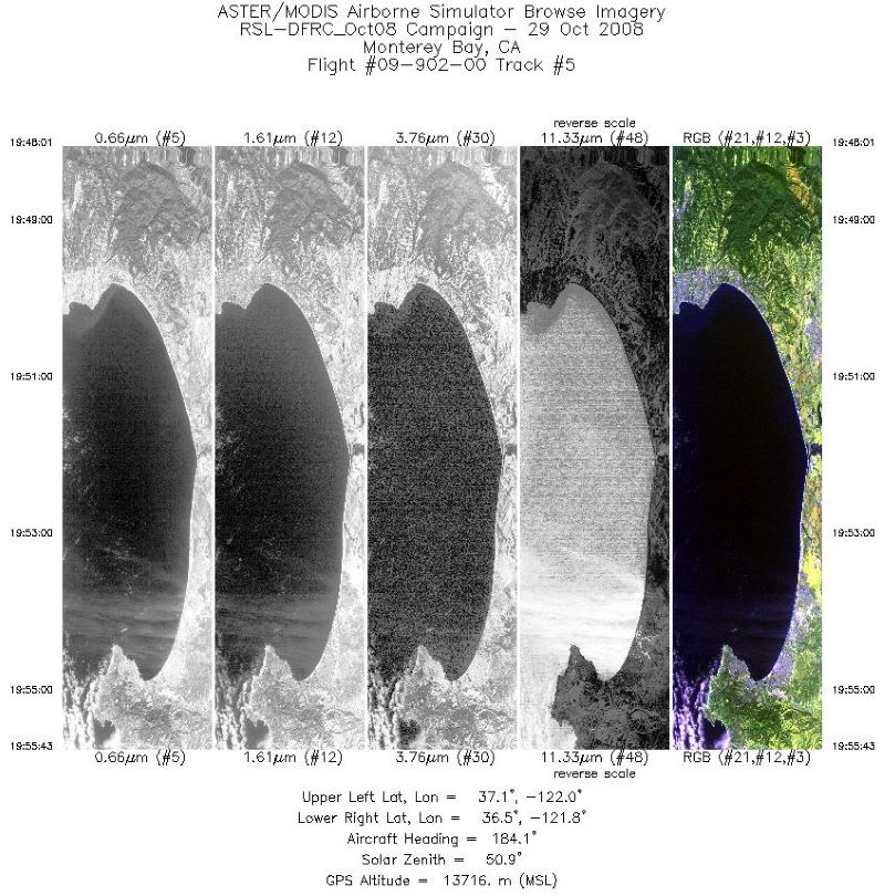
MASTER: Jornada Experiment-Airborne Science, Southwest US, October 2008
National Aeronautics and Space Administration —
This dataset includes Level 1B (L1B) data products from the MODIS/ASTER Airborne Simulator (MASTER) instrument. The spectral data were collected as part of the... -
Federal
AirMOSS: L4 Modeled Volumetric Root Zone Soil Moisture, 2012-2015
National Aeronautics and Space Administration —
This data set provides hourly gridded soil moisture estimates derived from hydrologic modeling at nine AirMOSS sites across North America. The AirMOSS L4 RZSM product... -
Federal
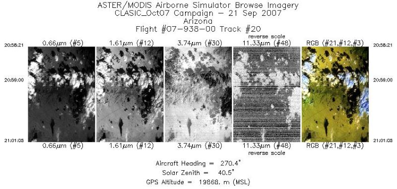
MASTER: Cloud And Land Surface Interaction Campaign, California-Oklahoma, 2007
National Aeronautics and Space Administration —
This dataset includes Level 1B (L1B) and Level 2 (L2) data products from the MODIS/ASTER Airborne Simulator (MASTER) instrument. The spectral data were collected... -
Federal
BOREAS HYD-03 1996 Tree Stem Density Data
National Aeronautics and Space Administration —
The BOREAS HYD-03 team collected several data sets related to the hydrology of forested areas. This data set contains measurements of stem density from a variety of...

Official websites use .gov
A
.gov website belongs to an official government
organization in the United States.
Secure .gov websites use HTTPS
A
lock (
) or https:// means you’ve safely connected to
the .gov website. Share sensitive information only on official,
secure websites.