
-
Federal
BOREAS TF-09 SSA-OBS Tower Flux, Meteorological, and Soil Temperature Data
National Aeronautics and Space Administration —
The BOREAS TF-09 team collected energy, carbon dioxide and water vapor flux data at the BOREAS SSA-OBS site during the growing season of 1994 and most of the year for... -
Federal
BOREAS TF-05 Tower Flux & Meteorological Data
National Aeronautics and Space Administration —
The BOREAS TF-05 team collected tower flux data at the BOREAS Southern Study Area Old Jack Pine (SSA-OJP) site through the growing season of 1994. -
Federal
BOREAS Follow-On HMet-04 1996-1998 NSA Meteorological Data
National Aeronautics and Space Administration —
As part of the BOREAS Follow-on, an extended period of data collection was supported in the NSA because of the continued efforts at the NSA-OBS site. This data set... -
Federal
BOREAS AES Canadian Hourly and Daily Surface Meteorological Data, R1
National Aeronautics and Space Administration —
This data set contains hourly and daily meteorological data from 23 meteorological stations across Canada from January 1975 to January 1997. The surface meteorology... -
Federal
BOREAS TE-11 Surface Meteorological Data
National Aeronautics and Space Administration —
The BOReal Ecosystem-Atmosphere Study (BOREAS) Terrestrial Ecology (TE)-11 team collected several data sets in support of its efforts to characterize and interpret... -
Federal
BOREAS TF-01 SSA-OA Tower Flux, Meteorological, and Soil Temperature Data
National Aeronautics and Space Administration —
The BOREAS TF-01 team collected energy, carbon dioxide, and momentum flux data above the canopy along with meteorological and soils data at the BOREAS SSA-OA site... -
Federal
BOREAS AES Five-day Averaged Surface Meteorological and Upper Air Data
National Aeronautics and Space Administration —
The Canadian Atmospheric Environment Service (AES) provided BOREAS with hourly and daily surface meteorological data from 23 of the AES meteorological stations... -
Federal
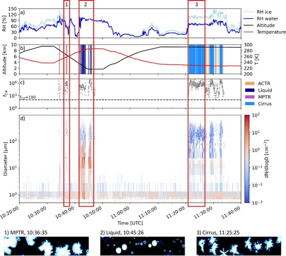
ATom: Development of Cloud Indicator Algorithm Using Airborne Observations from CAPS
National Aeronautics and Space Administration —
This dataset is the basis for the development of the Cloud Indicator, a novel algorithm that automatically detects and classifies measurement periods inside clouds.... -
Federal
AMS (Automated Met Station) Data (FIFE)
National Aeronautics and Space Administration —
As part of the FIFE staff science data collection effort, the FIFE Information System (FIS) processed and archived 5 minute, near-surface radiometric and... -
Federal
Aircraft Flux-Filtered: NRCC (FIFE)
National Aeronautics and Space Administration —
The purpose of this study was to develop alternatives to ground-based measurements in order to obtain information required to predict the effects of soil and land use... -
Federal
Aircraft Flux-Detrended: NRCC (FIFE)
National Aeronautics and Space Administration —
The purpose of this study was to develop alternatives to ground-based measurements in order to obtain information required to predict the effects of soil and land use... -
Federal
Aircraft Flux-Raw: NRCC (FIFE)
National Aeronautics and Space Administration —
The purpose of this study was to develop alternatives to ground-based measurements in order to obtain information required to predict the effects of soil and land use... -
Federal
Radiosonde Data: NOAA (FIFE)
National Aeronautics and Space Administration —
The NOAA Radiosonde Observations Data Set contains data that were extracted from the NOAA operational analysis system and transmitted to the FIS. Data are available... -
Federal
SAFARI 2000 TOVS Surface and Atmospheric Parameters, 1-Deg, 1999-2001
National Aeronautics and Space Administration —
NOAA's TIROS (Television Infrared Observation Satellite) Operational Vertical Sounder (TOVS) is a suite of three sensors: the Microwave Sounding Unit (MSU), the High... -
Federal
VEMAP 2: Monthly Ecosystem Model Responses to U.S. Climate Change, 1994-2100
National Aeronautics and Space Administration —
The Vegetation-Ecosystem Modeling and Analysis Project (VEMAP) was a large, collaborative, multi-institutional, international effort whose goal was to evaluate the... -
Federal
VEMAP 2: U.S. Daily Climate Change Scenarios
National Aeronautics and Space Administration —
The Vegetation/Ecosystem Modeling and Analysis Project (VEMAP) Phase 2 has developed a number of transient climate change scenarios based on coupled atmosphere-ocean... -
Federal
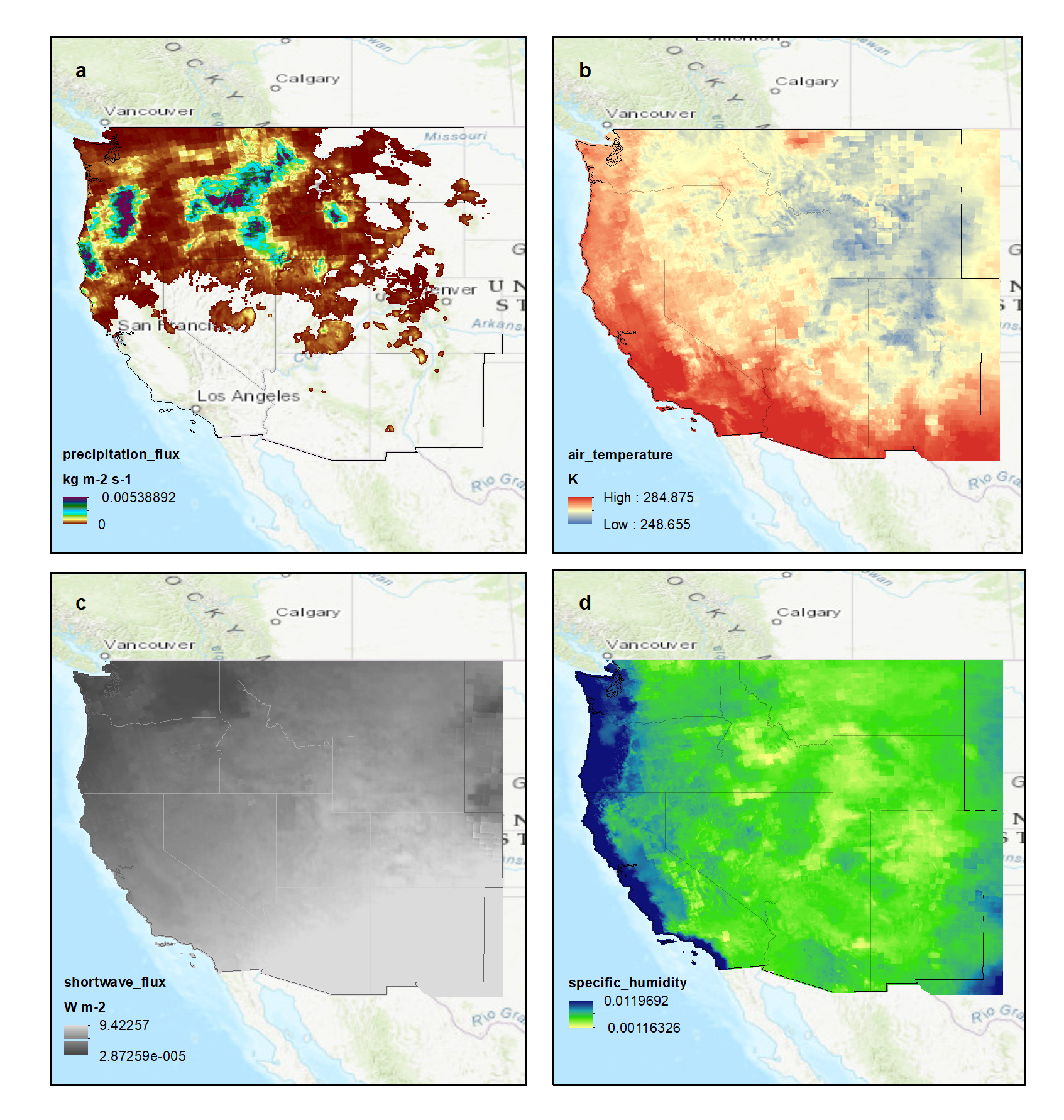
NACP: Climate Data Inputs (3-hourly) for Community Land Model, Western USA, 1979-2015
National Aeronautics and Space Administration —
This dataset provides sub-daily, high-resolution, climate data inputs including temperature, precipitation, near surface specific humidity, incoming short-wave... -
Federal
NPP Grassland: NPP Estimates from Biomass Dynamics for 31 Sites, 1948-1994, R1
National Aeronautics and Space Administration —
This data set includes monthly grassland biomass data, net primary productivity (NPP) estimates, and climate (rainfall amounts and temperature) data for multiple... -
Federal
Arctic Tundra Flux Study in the Kuparuk River Basin (Alaska), 1994-1996
National Aeronautics and Space Administration —
CO2 and water vapor fluxes and ecosystem characteristics were measured at 24 sites along a 317-km transect from the Arctic coast to the latitudinal treeline in Alaska... -
Federal
LBA-ECO ND-11 Soil Water Pressure and Flow Measurements under Tree Crops
National Aeronautics and Space Administration —
This data set contains information that can be used to examine water fluxes in soils beneath tree crops in an Amazonian agroforest. The data consists of repeated...

Official websites use .gov
A
.gov website belongs to an official government
organization in the United States.
Secure .gov websites use HTTPS
A
lock (
) or https:// means you’ve safely connected to
the .gov website. Share sensitive information only on official,
secure websites.