
-
Federal
LBA-ECO CD-32 LBA Model Intercomparison Project (LBA-MIP) Forcing Data
National Aeronautics and Space Administration —
The source meteorological observations for the forcing data, from the nine Brazilian flux towers, were recently published as Saleska, et al. (2013). See related data... -
Federal
SAFARI 2000 PAI Estimates from Hemispherical Photography, Kalahari Transect
National Aeronautics and Space Administration —
This data set was collected during February-March 2000 wet season and September 2000 dry season field campaigns of SAFARI 2000. Mongu in Zambia and Pandematenga (aka... -
Federal
FLUXNET Marconi Conference Gap-Filled Flux and Meteorology Data, 1992-2000
National Aeronautics and Space Administration —
Fluxes of carbon dioxide, water vapor, and energy exchange have been measured at 38 forest, grassland, and crop sites as part of the EUROFLUX and AmeriFlux projects.... -
Federal
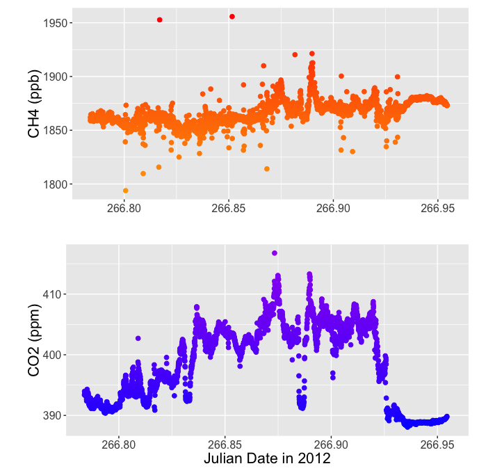
CARVE: L2 Merged Atmospheric CO2, CO, O3 and CH4 Concentrations, Alaska, 2012-2015
National Aeronautics and Space Administration —
This data set provides atmospheric carbon dioxide (CO2), methane (CH4), carbon monoxide (CO), ozone (O3), and water vapor (H2O) concentrations from airborne campaigns... -
Federal
COMEX: AMOG Surface Mobile in situ Data Surveyor, USA, 2014-2015
National Aeronautics and Space Administration —
This dataset provides AutoMObile trace Gas Surveyor (AMOG) in situ relevant datasets collected during the CO2 and Methane EXperiment (COMEX) field campaign and... -
Federal
SAFARI 2000 PAR Measurements, Kalahari Transect, Botswana, Wet Season 2000
National Aeronautics and Space Administration —
Ceptometer data from a Decagon AccuPAR (Model PAR-80) were collected at four sites in Botswana during the SAFARI 2000 Kalahari Transect Wet Season Campaign (March,... -
Federal
LBA-ECO LC-39 Modeled Carbon Flux from Deforestation, Mato Grosso, Brazil: 2000-2006
National Aeronautics and Space Administration —
This data set contains modeled estimates of carbon flux, biomass, and annual burning emissions across the Brazilian state of Mato Grosso from 2000-2006. The model,... -
Federal
BOREAS TE-06 Multiband Vegetation Imager Data
National Aeronautics and Space Administration —
A newly developed ground-based canopy imaging system called an MVI was tested and used by the BOREAS TE-06 team to collect measurements of the canopy gap fraction... -
Federal
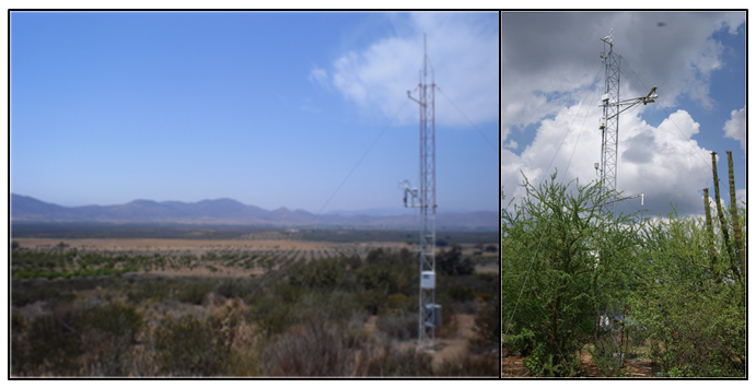
CMS: Evapotranspiration and Meteorology, Water-Limited Shrublands, Mexico, 2008-2010
National Aeronautics and Space Administration —
This data set provides daily average observations for evapotranspiration (measured and gap-filled), precipitation, net radiation, soil water content, air temperature,... -
Federal
NACP Site: Terrestrial Biosphere Model and Aggregated Flux Data in Standard Format
National Aeronautics and Space Administration —
This data set provides standardized output variables for gross primary productivity (GPP), net ecosystem exchange (NEE), leaf area index (LAI), ecosystem respiration... -
Federal
LBA-ECO ND-11 Forest Damage Following Reduced Impact Logging, NW Mato Grosso, Brazil
National Aeronautics and Space Administration —
Data were collected in the logging concession at the Fazenda Rohsamar in the municipality of Juruena in northwestern Mato Grosso. Estimates of damage associated with... -
Federal
NPP Tropical Forest: Marafunga, Papua New Guinea, 1970-1971, R1
National Aeronautics and Space Administration —
This data set contains two ASCII files (.txt format), one providing net primary production (NPP) component data for a lower montane rainforest and the other providing... -
Federal
BOREAS TE-23 Canopy Architecture and Spectral Data from Hemispherical Photos
National Aeronautics and Space Administration —
The BOREAS TE-23 team collected hemispherical photographs in support of its efforts to characterize and interpret information on estimates of canopy architecture and... -
Federal
SAFARI 2000 Leaf Area Index and Canopy Structure, Kalahari Transect, 1999-2000
National Aeronautics and Space Administration —
Data from the Tracing Radiation and Architecture of Canopies (TRAC) instrument were collected at five sites along the International Geosphere-Biosphere Programme... -
Federal
BOREAS Level-3S SPOT Imagery: Scaled At-Sensor Radiance in LGSOWG Format
National Aeronautics and Space Administration —
For BOREAS, the level-3s SPOT data, along with the other remotely sensed images, were collected in order to provide spatially extensive information over the primary... -
Federal
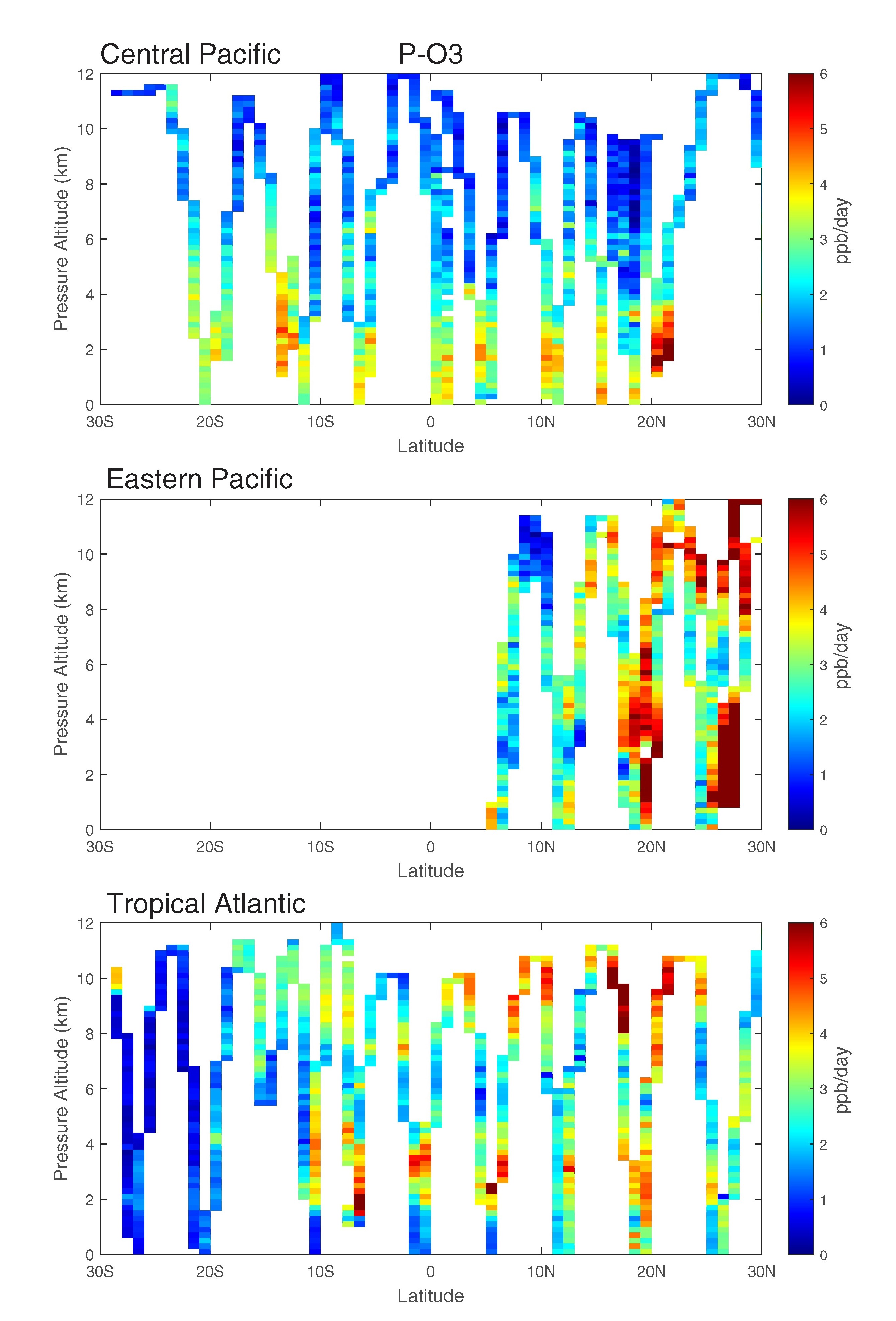
ATom: Data Stream for Modeling the Reactivity of ATom Air Parcels, 2016-2018
National Aeronautics and Space Administration —
This dataset provides Modeling Data Stream (MDS) and Reactivity Data Stream (RDS) products for each of the four ATom campaigns conducted from 2016 to 2018. MDS files... -
Federal
MODIS NDVI Data, Smoothed and Gap-filled, for the Conterminous US: 2000-2015
National Aeronautics and Space Administration —
This data set provides Moderate Resolution Imaging Spectroradiometer (MODIS) normalized difference vegetation index (NDVI) data, smoothed and gap-filled, for the...

Official websites use .gov
A
.gov website belongs to an official government
organization in the United States.
Secure .gov websites use HTTPS
A
lock (
) or https:// means you’ve safely connected to
the .gov website. Share sensitive information only on official,
secure websites.