
-
Federal
CMS: Forest Biomass and Productivity, 1-degree and 5-km, Conterminous US, 2005
National Aeronautics and Space Administration —
Notice: This data set and guide were updated on June 30, 2014 to correct an error in the reported units. The data values were not changed.Spatially-gridded estimates... -
Federal
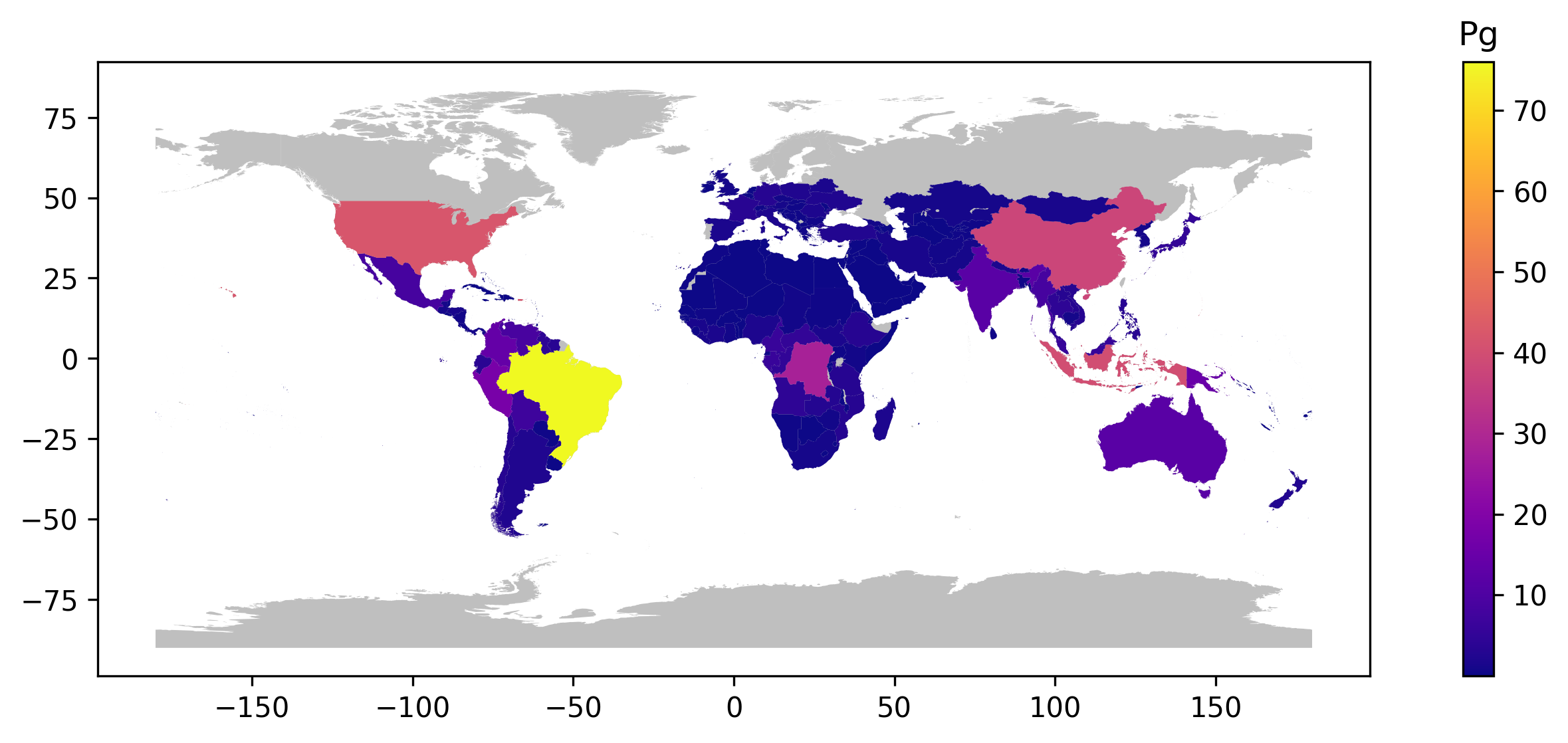
GEDI L4B Country-level Summaries of Aboveground Biomass
National Aeronautics and Space Administration —
This dataset provides country-level estimates of land surface mean aboveground biomass density (AGBD), total aboveground biomass (AGB) stocks, and the associated... -
Federal
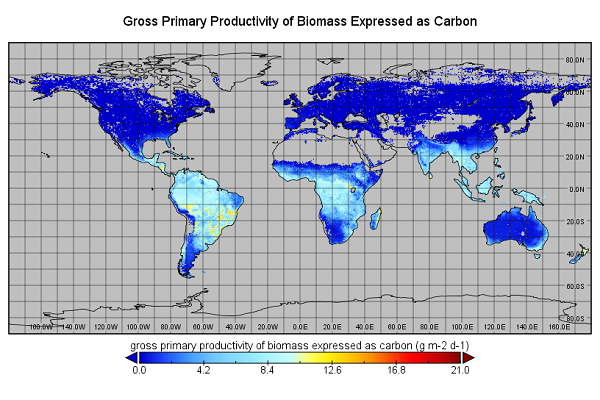
Global Monthly GPP from an Improved Light Use Efficiency Model, 1982-2016
National Aeronautics and Space Administration —
This dataset provides global monthly average gross primary productivity (GPP; g carbon/m2/d) modeled at 8 km spatial resolution for each of the 35 years from... -
Federal
Northern and Mid-Latitude Soil Database, Version 1, R1
National Aeronautics and Space Administration —
The U.S. Department of Agriculture, Agriculture and Agri-Food Canada, the Russian Academy of Agricultural Sciences, the University of Copenhagen Institute of... -
Federal
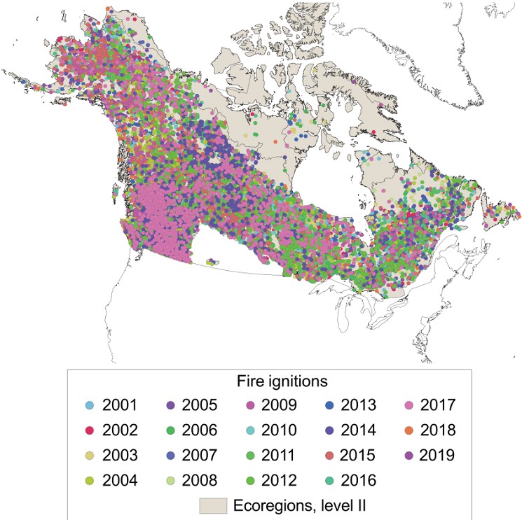
ABoVE: Ignitions of ABoVE-FED Fires in Alaska and Canada
National Aeronautics and Space Administration —
This dataset provides daily fire ignition locations and timing for boreal fires in Alaska, U.S., and Canada between 2001 and 2019. The fire ignition locations and... -
Federal
NPP Temperate Forest: Great Smoky Mountains, Tennessee, USA, 1968-1992, R1
National Aeronautics and Space Administration —
This data set contains two data files (.csv format). One file contains site characteristics, stand descriptors, and above-ground biomass and ANPP data for seven old-... -
Federal
ISLSCP II Snow-Free, Spatially Complete, 16 Day Albedo, 2002
National Aeronautics and Space Administration —
This data set, ISLSCP II Snow-Free, Spatially Complete, 16 Day Albedo, 2002, contains 9 files for snow-free, spatially complete 16-day global black-sky albedos at... -
Federal
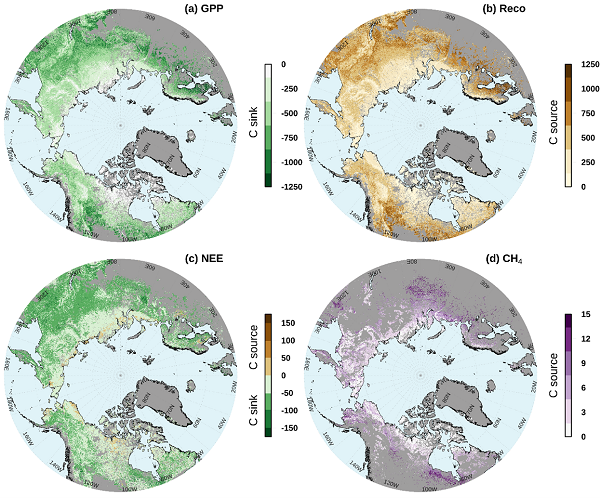
Gridded CO2 and CH4 Flux Estimates for pan-Arctic and Boreal Regions, 2003-2015
National Aeronautics and Space Administration —
This dataset provides gridded estimates of gross primary productivity (GPP), ecosystem respiration (Reco), net ecosystem CO2 exchange (NEE = Reco - GPP), and methane... -
Federal
LBA-ECO LC-02 Groundwater Levels, Catuaba Experimental Farm, Acre, Brazil: 1999-2004
National Aeronautics and Space Administration —
This data set reports bi-weekly or monthly depth-to-water measurements for three wells located in a ~1,500 ha forest fragment on the Catuaba Experimental Farm, which... -
Federal
LBA-ECO LC-07 Bathymetric Survey of Floodplain Lake, Lago Curuai, Para, Brazil: 2004
National Aeronautics and Space Administration —
The bathymetry data provided represent a continuous surface of interpolated point measurements of depth values of Lago Curuai, an Amazon River floodplain lake,... -
Federal
NPP Tropical Forest: San Carlos de Rio Negro, Venezuela, 1975-1984, R1
National Aeronautics and Space Administration —
This data set includes five ASCII files (.txt format). Three files contain above- and below-ground biomass and net primary productivity (NPP) data, one file for each... -
Federal
NPP Multi-Biome: NPP and Driver Data for Ecosystem Model-data Intercomparison, R2
National Aeronautics and Space Administration —
This data set represents a refined set of global net primary productivity (NPP) estimates and model driver data that are the results of the Ecosystem Model-Data... -
Federal
SAFARI 2000 SSM/I GPROF 6.0 Precipitation Data, 0.5-Deg, 1999-2001
National Aeronautics and Space Administration —
The GPROF 6.0 Pentads data set contains 5-day (pentad) averages of the GPROF 6.0 Gridded Orbits. The GPROF(Goddard Profiling Algorithm) data set contains a suite of 9... -
Federal
SAFARI 2000 AERONET-derived Diffuse Spectral Irradiance for Eight Core Sites
National Aeronautics and Space Administration —
This data set contains monthly mean values of diffuse irradiance fraction [f(Ediff), or ratio of diffuse-to-total irradiance] at ground level for a 30-degree solar... -
Federal
SAFARI 2000 TOMS Aerosol Index Data, Southern Africa, Dry Season 2000
National Aeronautics and Space Administration —
Daily Aerosol Index (AI) data from Earth Probe (EP) Total Ozone Mapping Spectrometer (TOMS) for the period of August 12-September 25, 2000 were processed and provided... -
Federal
SAFARI 2000 MAPSS MOD05_L2 Water Vapor Summary Data for Southern Africa
National Aeronautics and Space Administration —
The Moderate Resolution Imaging Spectroradiometer (MODIS) Atmosphere Group develops remote-sensing algorithms for deriving sets of atmospheric parameters from MODIS... -
Federal
SAFARI 2000 AOT and Column Water Vapor, Kalahari Transect, Wet Season 2000
National Aeronautics and Space Administration —
The data presented here include the aerosol optical thickness (AOT) and column water vapor measurements taken at sites along the Kalahari Transect using a Microtops... -
Federal
SAFARI 2000 AVHRR-derived Land Surface Temperature Maps, Africa, 1995-2000
National Aeronautics and Space Administration —
Land Surface Temperature (LST) is a key indicator of land surface states, and can provide information on surface-atmosphere heat and mass fluxes, vegetation water... -
Federal
SNF Forest Phenology/Leaf Expansion Data
National Aeronautics and Space Administration —
The purpose of the SNF study was to improve understanding of the relationship between remotely sensed observations and important biophysical parameters in the boreal... -
Federal
NS001 TMS Extracted Data (FIFE)
National Aeronautics and Space Administration —
As part of the FIFE staff science data processing effort, the FIFE Information System (FIS) extracted site average radiances from the level-1 NS001-TMS products. Data...

Official websites use .gov
A
.gov website belongs to an official government
organization in the United States.
Secure .gov websites use HTTPS
A
lock (
) or https:// means you’ve safely connected to
the .gov website. Share sensitive information only on official,
secure websites.