
-
Federal
Gridded CO2 and CH4 Flux Estimates for pan-Arctic and Boreal Regions, 2003-2015
National Aeronautics and Space Administration —
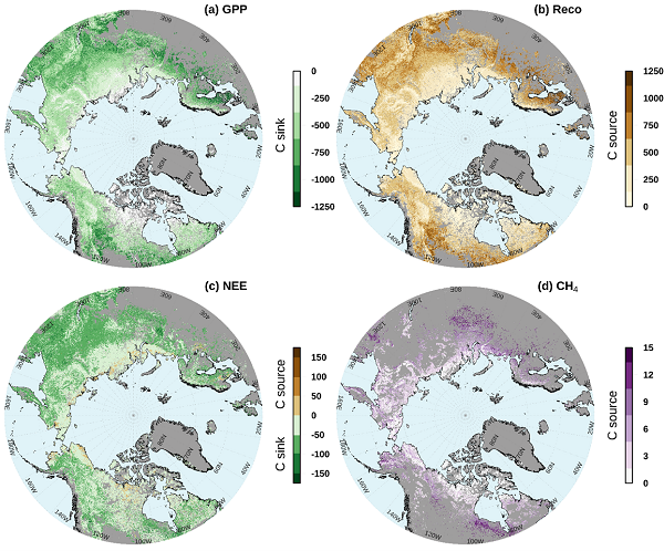
This dataset provides gridded estimates of gross primary productivity (GPP), ecosystem respiration (Reco), net ecosystem CO2 exchange (NEE = Reco - GPP), and methane... -
Federal
Global-Gridded Daily Methane Emissions from Inland Dam-Reservoir Systems
National Aeronautics and Space Administration —
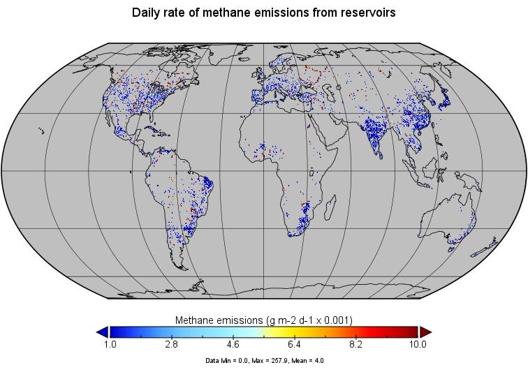
This dataset includes global maps of methane (CH4) emissions from inland dam-reservoir systems at 0.25-degree spatial resolution. Daily emission rates (as grams of... -
Federal
SAFARI 2000 Global Historical Climatology Network, V. 1, 1874-1990
National Aeronautics and Space Administration —
This data set consists of a southern African subset of the Global Historical Climatology Network (GHCN) Version 1 database. All stations with the following bounding... -
Federal
NACP MsTMIP: Global and North American Driver Data for Multi-Model Intercomparison
National Aeronautics and Space Administration —
This data set provides environmental data that have been standardized and aggregated for use as input to carbon cycle models at global (0.5-degree resolution) and... -
Federal
LBA Regional Organic Soil Carbon and Nitrogen Data (Zinke et al.)
National Aeronautics and Space Administration —
The data set contains a subset of a global organic soil carbon and nitrogen data set (Zinke et al. 1986). The subset was created for the study area of the Large Scale... -
Federal
Global Monthly Climatology for the Twentieth Century (New et al.)
National Aeronautics and Space Administration —
This is a data set of mean monthly surface climate data over global land areas, excluding Antarctica, for nearly all of the twentieth century. The data set is gridded... -
Federal
ISLSCP II Continuous Fields of Vegetation Cover, 1992-1993
National Aeronautics and Space Administration —
The objective of this study was to derive continuous fields of vegetation cover from multi-temporal Advanced Very High Resolution Radiometer (AVHRR) data using all... -
Federal
ISLSCP II NOAA 5-year Average Monthly Snow-free Albedo from AVHRR
National Aeronautics and Space Administration —
The objective of this work was to produce a monthly climatology of broadband surface albedos for use in global numerical weather prediction models at the National... -
Federal
SAFARI 2000 Vegetation and Soils, 1-Deg (Wilson and Henderson-Sellers)
National Aeronautics and Space Administration —
This data set contains a subset for southern Africa of Wilson and Henderson-Sellers' Global Vegetation & Soils 1-degree data. The data are available in both ASCII... -
Federal
SAFARI 2000 Monthly Climatology for the 20th Century (New et al.)
National Aeronautics and Space Administration —
This is a data set of mean monthly surface climate data over Southern Africa for nearly all of the twentieth century. The data set is gridded at 0.5 degree... -
Federal
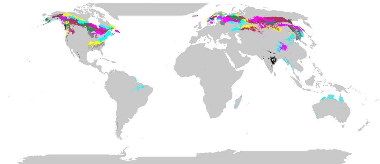
Phenoregions For Monitoring Vegetation Responses to Climate Change
National Aeronautics and Space Administration —
The overall purpose in this research was to identify the regions of the world best suited for long-term monitoring of biospheric responses to climate change, i.e.... -
Federal
NWS Daily Climatology Data: 1980 (SNF)
National Aeronautics and Space Administration —
Weather data were collected by the National Weather Service in International Falls, Minnesota. International Falls is about 80 miles from the SNF, but the weather... -
Federal
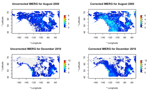
ABoVE: Bias-Corrected IMERG Monthly Precipitation for Alaska and Canada, 2000-2020
National Aeronautics and Space Administration —
This dataset is a modification to the Integrated Multi-satellitE Retrievals for GPM (IMERG) Final Run microwave-only, daily precipitation Version 06 data. It provides... -
Federal
SAFARI 2000 Mean Climatology, 0.5-Deg, 1930-1960, V[ersion]. 2.1 (Cramer and Leemans)
National Aeronautics and Space Administration —
This data set is a subset of the global mean monthly climatology (Cramer and Leemans 1999). The subset is for the area of southern Africa within the following bounds:... -
Federal
ABoVE: Lake and Pond Extents in Alaskan Boreal and Tundra Subregions, 2019-2021
National Aeronautics and Space Administration —
This dataset provides polygon spatial files of lake and pond extents for three sub-regions of Interior Alaska's boreal forest, and one tundra region located in... -
Federal
LBA Regional Land Cover from AVHRR, 8-km, 1984 (DeFries et al.)
National Aeronautics and Space Administration —
This data set is a subset of an 8-km global land cover product (DeFries et al. 1998). This subset was created for the study area of the Large Scale Biosphere-... -
Federal
ISLSCP II Global Precipitation Climatology Project Version 2, Monthly Precipitation
National Aeronautics and Space Administration —
The Global Precipitation Climatology Project (GPCP) Version 2 data set includes global, monthly precipitation rates and associated random errors (RMSE), and a monthly... -
Federal
NWS Daily Climatology Data: 1989 (SNF)
National Aeronautics and Space Administration —
Weather data were collected by the National Weather Service in International Falls, Minnesota. International Falls is about 80 miles from the SNF, but the weather...

Official websites use .gov
A
.gov website belongs to an official government
organization in the United States.
Secure .gov websites use HTTPS
A
lock (
) or https:// means you’ve safely connected to
the .gov website. Share sensitive information only on official,
secure websites.