
-
Federal
SAFARI 2000 MAPSS MOD05_L2 Water Vapor Summary Data for Southern Africa
National Aeronautics and Space Administration —
The Moderate Resolution Imaging Spectroradiometer (MODIS) Atmosphere Group develops remote-sensing algorithms for deriving sets of atmospheric parameters from MODIS... -
Federal
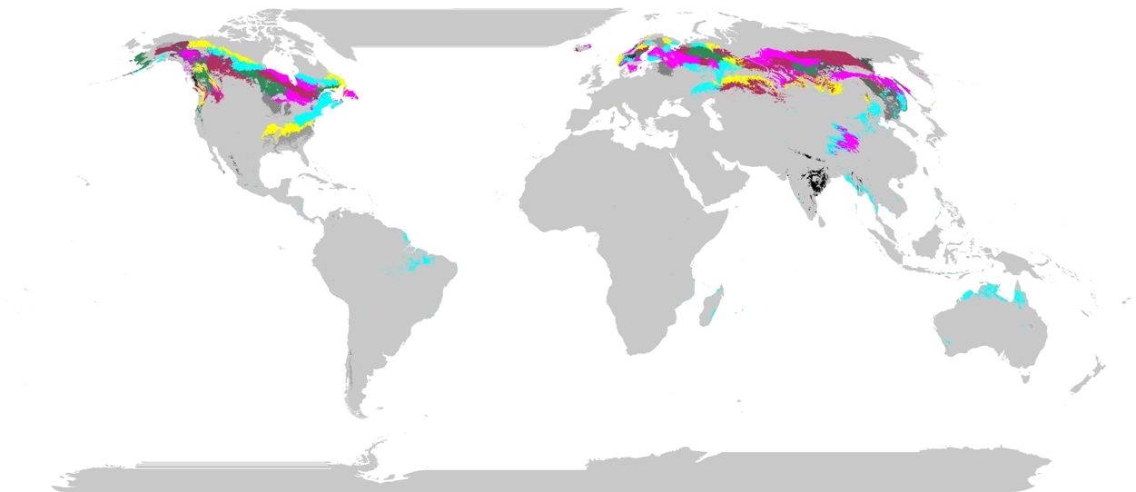
Phenoregions For Monitoring Vegetation Responses to Climate Change
National Aeronautics and Space Administration —
The overall purpose in this research was to identify the regions of the world best suited for long-term monitoring of biospheric responses to climate change, i.e.... -
Federal
Ecosystem Demography Model: Scaling Vegetation Dynamics Across South America
National Aeronautics and Space Administration —
This model product contains the source code for the Ecosystem Demography Model (ED version 1.0) as well as model input and output data for a portion of South America... -
Federal
SAFARI 2000 MAPSS MOD04_L2 Aerosol Summary Data for Southern Africa
National Aeronautics and Space Administration —
The Moderate Resolution Imaging Spectroradiometer (MODIS)Atmosphere Group develops remote sensing algorithms for deriving sets of atmospheric parameters from MODIS... -
Federal
LBA-ECO TG-07 Long-Term Soil Gas Flux and Root Mortality, Tapajos National Forest
National Aeronautics and Space Administration —
This data set reports measurements of trace gas fluxes of methane (CH4), nitric oxide (N2O), nitrous oxide (NO), carbon dioxide (CO2) from soils at a study site in... -
Federal
LBA-ECO ND-01 Streamwater and Watershed Characteristics, Rondonia, Brazil: 1998-1999
National Aeronautics and Space Administration —
This data set provides the results of (1) synoptic streamwater sampling and analyses from numerous sites across Rondonia and (2) corresponding watershed... -
Federal
LBA-ECO LC-22 Field Validation of MODIS Deforestation Detection, Brazil, 2005
National Aeronautics and Space Administration —
This data set contains field observations, corresponding GPS points, and point and polygons of deforested areas in the state of Mato Grosso, Brazil, for the period... -
Federal
LBA-ECO ND-11 Forest Damage Following Reduced Impact Logging, NW Mato Grosso, Brazil
National Aeronautics and Space Administration —
Data were collected in the logging concession at the Fazenda Rohsamar in the municipality of Juruena in northwestern Mato Grosso. Estimates of damage associated with... -
Federal
LBA-ECO CD-04 Leaf Area Index, km 83 Tower Site, Tapajos National Forest, Brazil
National Aeronautics and Space Administration —
Leaf area index was estimated in an 18 ha plot at the logged forest tower site, km 83, Tapajos National Forest, Para, Brazil. The plot was adjacent to the eddy flux... -
Federal
SAFARI 2000 Biomass Burning Emissions, Selected Sites, Dry Season 2000
National Aeronautics and Space Administration —
Biomass burning is a major source for gaseous and particulate atmospheric pollution over southern Africa and globally. The purpose of this study was to quantify... -
Federal
Leaf Area Index Maps at 30-m Resolution, Selected Sites, Canada
National Aeronautics and Space Administration —
This data set provides local LAI maps for the selected measured sites in Canada. These derived maps may also be useful for validating other LAI maps over these same... -
Federal
Global Soil Texture and Derived Water-Holding Capacities (Webb et al.)
National Aeronautics and Space Administration —
A standardized global data set of soil horizon thicknesses and textures (particle size distributions) was compiled by Webb et al. This data set will be used for the... -
Federal
LBA-ECO ND-01 Georegistered Landsat Imagery for Rondonia, Brazil: 1975-2000
National Aeronautics and Space Administration —
This data set provides a time series of Landsat Multispectral Scanner (MSS), Thematic Mapper (TM), and Enhanced Thematic Mapper Plus (ETM+) scenes for five (Path/Row)... -
Federal
SAFARI 2000 Leaf Spectral Measurements, Kalahari Transect, Wet Season 2000
National Aeronautics and Space Administration —
The Boston University team collected several data sets along the Kalahari Transect during the SAFARI 2000 wet season field campaign between March 3 and March 18, 2000... -
Federal
LBA-ECO LC-22 Field Validation of MODIS Deforestation Detection, Brazil, 2003-2004
National Aeronautics and Space Administration —
This data set contains field observations, corresponding GPS points, and point and polygons of deforested areas in the state of Mato Grosso, Brazil, for the period... -
Federal
LBA-ECO CD-34 Hyperion 30-m Surface Reflectance, Amazon Basin: 2002-2005
National Aeronautics and Space Administration —
This data set contains 20 multispectral surface reflectance images collected by the EO-1 satellite Hyperion sensor at 30-m resolution and covering the entire Amazon... -
Federal
ISLSCP II IGBP DISCover and SiB Land Cover, 1992-1993
National Aeronautics and Space Administration —
This data set describes the geographic distributions of 17 classes of land cover based on the International Geosphere-Biosphere DISCover land cover legend (Loveland... -
Federal
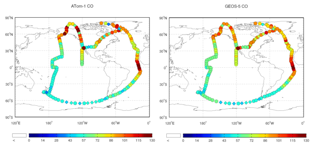
ATom: Observed and GEOS-5 Simulated CO Concentrations with Tagged Tracers for ATom-1
National Aeronautics and Space Administration —
This dataset contains carbon monoxide (CO) observations at 10-second intervals from flights during the ATom-1 campaign in 2016 and simulated CO concentrations from... -
Federal
Daymet: Station-Level Inputs and Cross-Validation for North America, Version 4 R1
National Aeronautics and Space Administration —
This dataset reports the station-level daily weather observation data and the corresponding cross-validation results for three Daymet model parameters: minimum...

Official websites use .gov
A
.gov website belongs to an official government
organization in the United States.
Secure .gov websites use HTTPS
A
lock (
) or https:// means you’ve safely connected to
the .gov website. Share sensitive information only on official,
secure websites.