
-
Federal
CAR SnowEx17 Snow Mass and Energy Measurements L1 V1 (CAR_SNOWEX17_L1C) at GES DISC
National Aeronautics and Space Administration —
SnowEx is a multi-year airborne project to help advance capabilities, and plan for a near-future space mission to monitor global seasonal snow water equivalent —... -
Federal
CALIPSO Lidar Level 3 Stratospheric Aerosol Profiles Standard V1-01
National Aeronautics and Space Administration —
CAL_LID_L3_Stratospheric_APro-Standard-V1-01 is the Cloud-Aerosol Lidar and Infrared Pathfinder Satellite Observation (CALIPSO) Lidar Level 3 Stratospheric Aerosol... -
Federal
BOREAS/SRC AMS Suite B Surface Meteorological and Radiation Data: 1994
National Aeronautics and Space Administration —
The Saskatchewan Research Council (SRC) collected surface meteorological and radiation data from December, 1993 until Decemb er 1996. The data set is comprised of the... -
Federal
BOREAS Level-0 AOCI Imagery: Digital Counts in BIL Format
National Aeronautics and Space Administration —
The level-0 AOCI imagery, along with the other remotely sensed images, was collected to provide spatially extensive information about radiant energy over the primary... -
Federal
TROPICS06 L1A Orbital Geolocated Native-Resolution Antenna Temperatures V1.0
National Aeronautics and Space Administration —
The "Time-Resolved Observations of Precipitation structure and storm Intensity with a Constellation of Smallsats" (TROPICS) mission has a goal of providing nearly... -
Federal
SAFARI 2000 GPCP Daily Precipitation, 1-Deg, 1999-2001
National Aeronautics and Space Administration —
The Global Precipitation Climatology Project (GPCP) is an international project designed to provide improved long-record estimates of precipitation over the globe.... -
Federal
NPP Multi-Biome: Global Osnabruck Data, 1937-1981, R1
National Aeronautics and Space Administration —
This data set contains three files. The first file provides net primary productivity (NPP) estimates, vegetation characteristics, and summary climate data for 720... -
Federal
TROPESS CrIS-SNPP L2 Carbon Monoxide for West Coast Fires HiRes, Standard Product V1 (TRPSDL2COCRSWCFHI) at GES DISC
National Aeronautics and Space Administration —
The TROPESS CrIS-SNPP L2 Carbon Monoxide for West Coast Fires HiRes, Standard Product contains the vertical distribution of the retrieved atmospheric state of carbon... -
Federal
BOREAS HYD-04 Standard Snow Course Data
National Aeronautics and Space Administration —
The BOREAS HYD-04 work was focused on collecting data during the winter field campaign (FFC-W) to improve the understanding of winter processes within the boreal... -
Federal
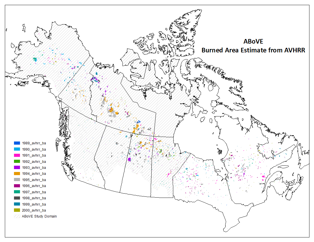
ABoVE: AVHRR-Derived Forest Fire Burned Area-Hot Spots, Alaska and Canada, 1989-2000
National Aeronautics and Space Administration —
This dataset provides annual forest fire burned area and daily hotspot products developed using data acquired from the Advanced Very-High-Resolution Radiometer... -
Federal
MLS/Aura Level 3 Monthly Binned Chlorine Monoxide (ClO) Mixing Ratio on Assorted Grids V005 (ML3MBCLO) at GES DISC
National Aeronautics and Space Administration —
ML3MBCLO is the EOS Aura Microwave Limb Sounder (MLS) monthly binned on various vertical grids product for chlorine monoxide (ClO) derived from radiances measured... -
Federal
MLS/Aura Level 2 Hydroxyl (OH) Mixing Ratio V005 (ML2OH) at GES DISC
National Aeronautics and Space Administration —
ML2OH is the EOS Aura Microwave Limb Sounder (MLS) standard product for hydroxyl derived from radiances measured by the THz radiometer. The data version is 5.0. Data... -
Federal
BOREAS Follow-On DSP-10 Regridded Moss Cover Maps for 1994
National Aeronautics and Space Administration —
Existing 1-km moss cover classifications were reprocessed and are now available at multiple resolutions (2 km, 10x5 minutes, and 0.5 degree). These data were... -
Federal
MOPITT Beta CO gridded monthly means (Near and Thermal Infrared Radiances) V109
National Aeronautics and Space Administration —
MOP03JM_109 is the Measurements Of Pollution In The Troposphere (MOPITT) Beta CO gridded monthly means (Near and Thermal Infrared Radiances) version 109 product. It... -
Federal
NWS Daily Climatology Data: 1986 (SNF)
National Aeronautics and Space Administration —
Weather data were collected by the National Weather Service in International Falls, Minnesota. International Falls is about 80 miles from the SNF, but the weather... -
Federal
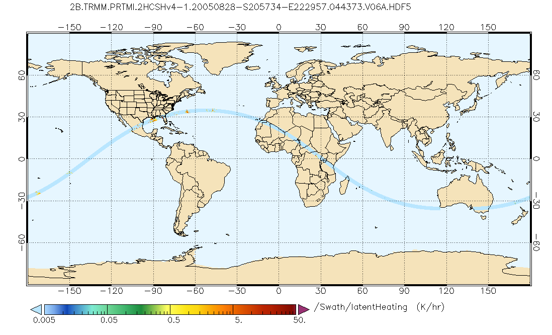
GPM PR and TMI on TRMM Combined Convective-Stratiform Latent Heating Profiles L2 1.5 hours 5 km V07 (GPM_2HCSH_TRMM) at GES DISC
National Aeronautics and Space Administration —
This is a new (GPM-formated) TRMM product. The equivalent old TRMM legacy product is TRMM_2H31.Version 07 is the current version of the data set. Older versions will... -
Federal
OMI/Aura TOMS-Like Ozone and Radiative Cloud Fraction L3 1 day 0.25 degree x 0.25 degree V004 (OMTO3e) at GES DISC
National Aeronautics and Space Administration —
The OMI science team produces this Level-3 Aura/OMI Global TOMS-Like Total Column Ozone gridded product OMTO3e (0.25deg Lat/Lon grids). The OMTO3e product selects the... -
Federal
Pre-Delta-X: L2 AVIRIS-NG Surface Spectral Reflectance across MRD, LA, USA, 2015-2016
National Aeronautics and Space Administration —
This Level 2 (L2) dataset provides surface spectral reflectance data acquired over the Atchafalaya and Terrebonne basins of the Mississippi River Delta (MRD) of...

Official websites use .gov
A
.gov website belongs to an official government
organization in the United States.
Secure .gov websites use HTTPS
A
lock (
) or https:// means you’ve safely connected to
the .gov website. Share sensitive information only on official,
secure websites.