
-
Federal
NARSTO Pacific 2001 Air Quality Study (PAC2001) Greater Vancouver Regional District (GVRD) and and Canadian Air and Precipitation Monitoring Network (CAPMoN) Supplemental Air Quality Data recent views
National Aeronautics and Space Administration —
NARSTO_PAC2001_GVRD_CAPMON_AIR_QUAL_DATA is the North American Research Strategy for Tropospheric Ozone (NARSTO) Pacific 2001 Air Quality Study (PAC2001) Greater... -
Federal
U.S. Daily Climate Normals (1971-2000) recent views
National Oceanic and Atmospheric Administration, Department of Commerce —
The U.S. Daily Climate Normals (DSI-9641D) are based on monthly maximum, minimum, and mean temperature and monthly total precipitation records for each year in the... -
Federal
GPM Ground Validation Raw Autonomous Parsivel Unit (APU) IFloodS V1 recent views
National Aeronautics and Space Administration —
The GPM Ground Validation Raw Autonomous Parsivel Unit (APU) IFloodS dataset was collected by 14 Autonomous Parsivel Unit (APU) sites in eastern Iowa during the... -
Federal
NOAA GOES-R Series Advanced Baseline Imager (ABI) Level 2 Fog/Low Stratus (FLS) recent views
National Oceanic and Atmospheric Administration, Department of Commerce —
The GOES-R Advanced Baseline Imager (ABI) Fog/Low Stratus (FLS) products contain estimates of low cloud/fog thickness and probabilities of reduced aviation visibility... -
Federal
Lightning Imaging Sensor (LIS) on TRMM Backgrounds V4 recent views
National Aeronautics and Space Administration —
The Lightning Imaging Sensor (LIS) Backgrounds was collected by the LIS instrument on the Tropical Rainfall Measuring Mission (TRMM) satellite used to detect the... -
Federal
OMPS-NPP L2 LP Aerosol Extinction Vertical Profile swath daily 3slit V2 (OMPS_NPP_LP_L2_AER_DAILY) at GES DISC recent views
National Aeronautics and Space Administration —
The OMPS-NPP L2 LP Aerosol Extinction Vertical Profile swath daily 3slit (AER) product contains the retrieved aerosol extinction coefficients measured by the Ozone... -
Federal
TRMM TROPICAL CYCLONE PRECIPITATION FEATURE (TCPF) DATABASE - LEVEL 1 V1 recent views
National Aeronautics and Space Administration —
The TRMM Cyclone Precipitation Feature (TCPF) Database - Level 1 provides Tropical Rainfall Measuring Mission (TRMM)-based tropical cyclone data in a common framework... -
Federal
TROPESS Chemical Reanalysis Surface NO 2-Hourly 2-dimensional Product V1 (TRPSCRNO2H2D) at GES DISC recent views
National Aeronautics and Space Administration —
The TROPESS Chemical Reanalysis NO 2-Hourly 2-dimensional Product contains the surface concentrations of nitric oxide. The data are part of the Tropospheric Chemical... -
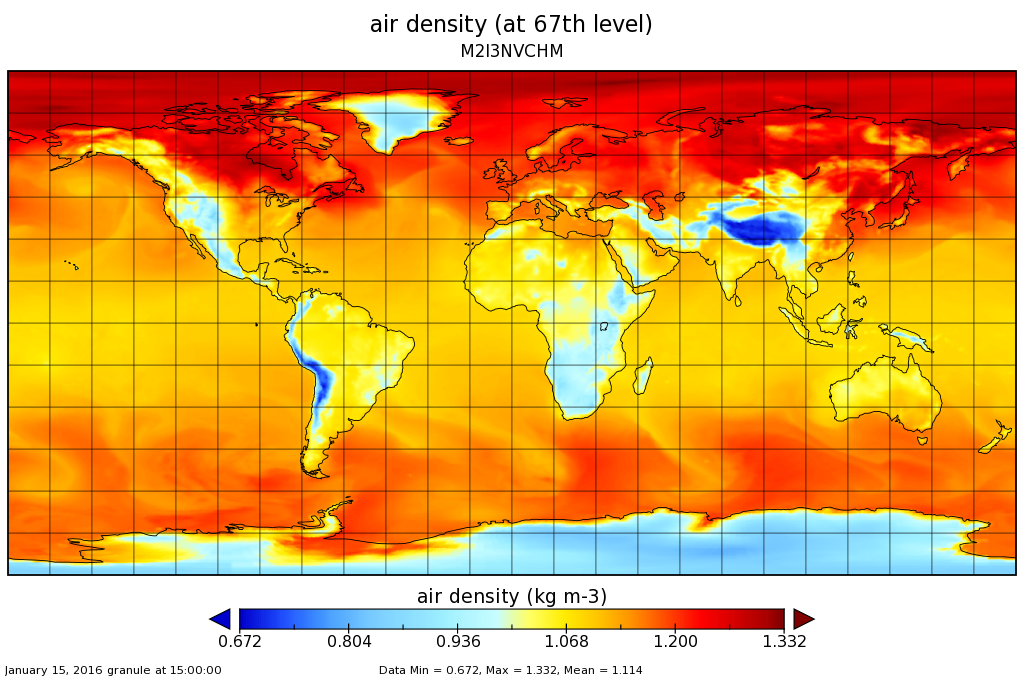
Federal
MERRA-2 inst3_3d_chm_Nv: 3d,3-Hourly,Instantaneous,Model-Level,Assimilation,Carbon Monoxide and Ozone Mixing Ratio 0.625 x 0.5 degree V5.12.4 (M2I3NVCHM) at GES DISC recent views
National Aeronautics and Space Administration —
M2I3NVCHM (or inst3_3d_chm_Nv) is an instantaneous 3-dimensional 3-hourly data collection in Modern-Era Retrospective analysis for Research and Applications version 2... -
Federal
GPM Ground Validation UND Citation Cloud Microphysics OLYMPEX V1 recent views
National Aeronautics and Space Administration —
The GPM Ground Validation UND Citation Cloud Microphysics OLYMPEX dataset includes measurements of cloud microphysics, state of the atmosphere parameters, three-... -
Federal
Sentinel-5P TROPOMI Tropospheric Formaldehyde HCHO 1-Orbit L2 7km x 3.5km V1 (S5P_L2__HCHO__) at GES DISC recent views
National Aeronautics and Space Administration —
Starting from August 6th in 2019, Sentinel-5P TROPOMI along-track high spatial resolution (~5.5km at nadir) has been implemented. Starting from July 13th in 2020,... -
Federal
Saildrone Atlantic 2023 Hurricane Monitoring Surface Data, drone 1031 recent views
National Oceanic and Atmospheric Administration, Department of Commerce —
Using Uncrewed Surface Vehicles (USV) to observe air-sea interaction associated with Tropical Cyclones (TC), which is critical to TC intensification. -
Federal
Saildrone Atlantic 2023 Hurricane Monitoring Surface Data, drone 1036 recent views
National Oceanic and Atmospheric Administration, Department of Commerce —
Using Uncrewed Surface Vehicles (USV) to observe air-sea interaction associated with Tropical Cyclones (TC), which is critical to TC intensification. -
Federal
ISLSCP II Globalview: Atmospheric CO2 Concentrations recent views
National Aeronautics and Space Administration —
The GlobalView Carbon Dioxide (CO2) data product contains synchronized and smoothed time series of atmospheric CO2 concentrations at selected sites that were created... -
Federal
NOAA AOML PMEL Hurricane Monitoring 2024 NRT Saildrone 1091 recent views
National Oceanic and Atmospheric Administration, Department of Commerce —
(1) Real-time steering of USVs toward tropical cyclones and other strong low-pressure systems, based on forecasted tracks and the knowledge and experience gained from... -
Federal
Saildrone Atlantic 2023 Hurricane Monitoring Surface Data, drone 1040 recent views
National Oceanic and Atmospheric Administration, Department of Commerce —
Using Uncrewed Surface Vehicles (USV) to observe air-sea interaction associated with Tropical Cyclones (TC), which is critical to TC intensification. -
Federal
GPM IMERG Late Precipitation L3 1 day 0.1 degree x 0.1 degree V06 (GPM_3IMERGDL) at GES DISC recent views
National Aeronautics and Space Administration —
The Integrated Multi-satellitE Retrievals for GPM (IMERG) is the unified U.S. algorithm that provides the multi-satellite precipitation product for the U.S. GPM team.... -
Federal
NOAA Profiler Network (NPN) Vertical Wind Profile Data recent views
National Oceanic and Atmospheric Administration, Department of Commerce —
The NOAA Profiler Network (NPN) radars provide vertical profiles of horizontal wind speed and direction from near the surface to above the tropopause. The system also... -
Federal
30 Minute Rainfall Data (FIFE) recent views
National Aeronautics and Space Administration —
30 minute rainfall data for the Konza Prairie

Official websites use .gov
A
.gov website belongs to an official government
organization in the United States.
Secure .gov websites use HTTPS
A
lock (
) or https:// means you’ve safely connected to
the .gov website. Share sensitive information only on official,
secure websites.