
-
Federal
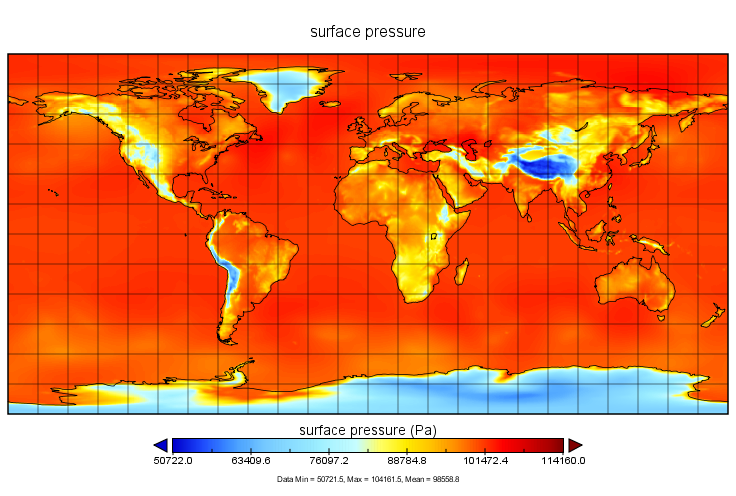
MERRA-2 tavg3_3d_cld_Nv: 3d,3-Hourly,Time-Averaged,Model-Level,Assimilation,Cloud Diagnostics 0.625 x 0.5 degree V5.12.4 (M2T3NVCLD) at GES DISC
National Aeronautics and Space Administration —
M2T3NVCLD (or tavg3_3d_cld_Nv) is a 3-dimensional 3-hourly time averaged data collection in Modern-Era Retrospective analysis for Research and Applications version 2... -
Federal
LINKAGES: An Individual-based Forest Ecosystem Biogeochemistry Model
National Aeronautics and Space Administration —
This model product contains the source codes for version 1 of the individual-based forest ecosystem biogeochemistry model LINKAGES and two subsequent versions as well... -
Federal
MISR Level 1B2 Terrain Data subset for the UAE region V002
National Aeronautics and Space Administration —
UAEMIB2T_002 is the Multi-angle Imaging SpectroRadiometer (MISR) Level 1B2 Terrain Data subset for the UAE region version 2 data product. It contains Terrain-... -
Federal
LBA-ECO CD-03 Cloud Base-Backscatter Data, km 67 Tower Site, Tapajos National Forest
National Aeronautics and Space Administration —
A Vaisala CT-25K ceilometer was installed at an old-growth forest site located at the km 67 Eddy Flux Tower site in the Tapajos National Forest, Para, Brazil, off... -
Federal
MetOp-B ASCAT Level 2 Ocean Surface Wind Vectors Optimized for Coastal Ocean
National Aeronautics and Space Administration —
This dataset contains operational near-real-time Level 2 coastal ocean surface wind vector retrievals from the Advanced Scatterometer (ASCAT) on MetOp-B at 12.5 km... -
Federal
CYGNSS Level 3 MRG Science Data Record Version 3.2.2
National Aeronautics and Space Administration —
This dataset contains the version 3.2.2 CYGNSS level 3 science data record merged storm (MRG) wind speed which combines CYGNSS storm-centric gridded (SCG) wind... -
Federal
ENVISAT MERIS Global Binned Cyanobacteria Index (CI) Data, version 5.0
National Aeronautics and Space Administration —
Cyanobacteria Assessment Network (CyAN) is a multi-agency project among EPA, the National Aeronautics and Space Administration (NASA), the National Oceanic and... -
Federal
DC3 Merge Data Files
National Aeronautics and Space Administration —
DC3_Merge_Data are pre-generated merge data files collected during the Deep Convective Clouds and Chemistry (DC3) field campaign. This product contains merged data... -
Federal
CYGNSS Level 3 Climate Data Record Version 1.0
National Aeronautics and Space Administration —
This dataset contains the Version 1.0 CYGNSS Level 3 Climate Data Record which provides the average wind speed and mean square slope (MSS) on a 0.2x0.2 degree... -
Federal
Daily FluxSat GPP of biomass over Land, Based on MODIS Terra and Aqua adjusted reflectance Collection 6.1, on a Global 0.5 by 0.625 Degree Grid, Level 3 Version 2.2
National Aeronautics and Space Administration —
This dataset provides global gridded daily estimates of gross primary production (GPP) and uncertainties at 0.5 deg latitude by 0.625 deg longitude resolution for the... -
Federal
CYGNSS Level 2 Climate Data Record Version 1.1
National Aeronautics and Space Administration —
This dataset contains the Version 1.1 CYGNSS Level 2 Climate Data Record which provides the time-tagged and geolocated average wind speed (m/s) and mean square slope... -
Federal
Cross-track Infrared Sounder (CrIS) Level 2 Earth System Science Profiling Algorithm Ammonia Retrieval Algorithm (ESSPA-NH3) V1 (SNDRSNIL2ESPNH3)
National Aeronautics and Space Administration —
The objective of this limited edition data collection is to examine the ammonia products generated by the ESSPA (Earth System Science Profiling Algorithm) algorithm... -
Federal
Delta-X: AirSWOT Level 1B Interferogram Products in Radar Coordinates, 2021
National Aeronautics and Space Administration —
This dataset contains AirSWOT interferogram products collected during the 2021 Delta-X Campaign over the Atchafalaya and Terrebonne Basins of the Mississippi River... -
Federal
NARSTO EPA Supersite (SS) Fresno, Particulate Matter (PM) 2.5 Organic and Elemental Carbon Data
National Aeronautics and Space Administration —
NARSTO_EPA_SS_FRESNO_PM25_OC_EC is the North American Research Strategy for Tropospheric Ozone (NARSTO) Environmental Protection Agency (EPA) Supersite (SS) Fresno,... -
Federal
OCO-2 Level 2 bias-corrected XCO2 and other select fields from the full-physics retrieval, Forward processing V11.2 (OCO2_L2_Fwd_FP_11.2)
National Aeronautics and Space Administration —
Version 11.2 is the current version of the data set. The OCO-2 Full-physics Forward processing files contain bias-corrected XCO2 along with other select fields... -
Federal
Northern Hemisphere EASE-Grid 2.0 Weekly Snow Cover and Sea Ice Extent, Version 4
National Aeronautics and Space Administration —
The main parameters for this data set are snow cover and sea ice extent; both parameters are derived from SMMR and DMSP-F8, -F11, -F13, and -F17 SSM/I and SSMIS... -
Federal
NLDAS Primary Forcing Data L4 Hourly 0.125 x 0.125 degree V2.0 (NLDAS_FORA0125_H) at GES DISC
National Aeronautics and Space Administration —
This data set contains the primary forcing hourly data "File A" for Phase 2 of the North American Land Data Assimilation System (NLDAS-2). The data are in 1/8th... -
Federal
MODIS/Terra Surface Reflectance Daily L2G Global 1km and 500m SIN Grid NRT
National Aeronautics and Space Administration —
The MODIS/Terra Surface Reflectance Daily L2G Global 1km and 500m SIN Grid Near Real Time (NRT) product is an estimate of the surface spectral reflectance as it would... -
Federal
MOPITT CO gridded daily means (Thermal Infrared Radiances) V009
National Aeronautics and Space Administration —
MOP03T_9 is the Measurements Of Pollution In The Troposphere (MOPITT) Carbon Monoxide (CO) gridded daily means (Thermal Infrared Radiances) version 9 data product. It...

Official websites use .gov
A
.gov website belongs to an official government
organization in the United States.
Secure .gov websites use HTTPS
A
lock (
) or https:// means you’ve safely connected to
the .gov website. Share sensitive information only on official,
secure websites.