
-
Federal
NPP Grassland: Bridger, USA, 1970-1973, R1
National Aeronautics and Space Administration —
This data set contains three ASCII text files for the Bridger grassland study site in the Rocky Mountains (45.78 N, -110.78 W, Elevation 2,340 m). Two files contain... -
Federal
NARSTO Pacific 2001 Air Quality Study (PAC2001) Golden Ears Gaseous and Particulate Matter (PM) Data
National Aeronautics and Space Administration —
NARSTO_PAC2001_GOLDEN_EARS_GAS_PM_DATA is the North American Research Strategy for Tropospheric Ozone (NARSTO) Pacific 2001 Air Quality Study (PAC2001) Golden Ears... -
Federal
TOLNet NASA Goddard Space Flight Center Data
National Aeronautics and Space Administration —
TOLNet_GSFC_Data is the lidar data collected by the Tropospheric Ozone (TROPOZ) lidar at the Goddard Space Flight Center (GSFC) as part of the Tropospheric Ozone... -
Federal
NPP Tropical Forest: John Crow Ridge, Jamaica, 1974-1978, R1
National Aeronautics and Space Administration —
This data set contains five NPP data files and three climate data files (ASCII .txt format). There is one NPP file for each of the five sub-types of upper montane... -
Federal
NARSTO PAC2001 CFS Cessna VOC, Particle Count, Ozone, and Meteorological Data
National Aeronautics and Space Administration —
The NARSTO_PAC2001_CESSNA_VOC_PM_OZONE_MET_DATA were obtained between August 14 and August 31, 2001 during the Pacific 2001 Air Quality Study (PAC2001).The missions... -
Federal
GPM Ground Validation Airborne Precipitation Radar 3rd Generation (APR-3) OLYMPEX V2
National Aeronautics and Space Administration —
The GPM Ground Validation Airborne Precipitation Radar 3rd Generation (APR-3) OLYMPEX V2 dataset was collected from November 12, 2015 to December 19, 2015 during the... -
Federal
Forest Biophysical Parameters (SNF)
National Aeronautics and Space Administration —
The purpose of the SNF study was to improve our understanding of the relationship between remotely sensed observations and important biophysical parameters in the... -
Federal
GPM Ground Validation Cloud Physics LiDAR (CPL) OLYMPEX V1
National Aeronautics and Space Administration —
The GPM Ground Validation Cloud Physics Lidar (CPL) OLYMPEX dataset consists of extinction profiles, layer optical depth, layer lidar ratio, and aircraft parameter... -
Federal
GPM Ground Validation KRTX NEXRAD OLYMPEX V1
National Aeronautics and Space Administration —
The GPM Ground Validation KRTX NEXRAD OLYMPEX dataset contains data from selected NEXt Generation Weather RADar system (NEXRAD) instruments in operation during the... -
Federal
DISCOVER-AQ Colorado Deployment Table Mountain Ground Site Data
National Aeronautics and Space Administration —
DISCOVERAQ_Colorado_Ground_TableMountain_Data contains data collected at the Table Mountain ground site during the Colorado (Denver) deployment of NASA's DISCOVER-AQ... -
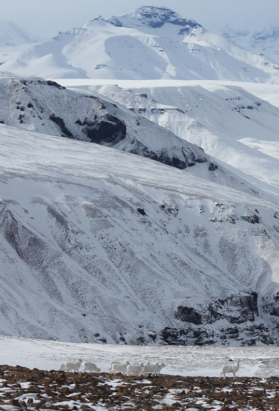
Federal
ABoVE: Dall Sheep Lamb Recruitment and Climate Data, Alaska and NW Canada, 2000-2015
National Aeronautics and Space Administration —
This dataset contains estimated annual average Dall sheep (Ovis dalli dalli) lamb-to-ewe ratios for each year from 2000-2015 across the full species range in Alaska... -
Federal
H11447: NOS Hydrographic Survey , Wrangell Narrows, Alaska, 2006-05-26
National Oceanic and Atmospheric Administration, Department of Commerce —
The National Oceanic and Atmospheric Administration (NOAA) has the statutory mandate to collect hydrographic data in support of nautical chart compilation for safe... -
Federal
2012 NOAA American Samoa Lidar DEM: Islands of Tutuila, Aunu'u, Ofu, Olosega, Ta'u and Rose Atoll
National Oceanic and Atmospheric Administration, Department of Commerce —
Light Detection and Ranging (LiDAR) data is remotely sensed high-resolution elevation data collected by an airborne collection platform. This LiDAR dataset is a... -
Federal
H11147N: NOS Hydrographic Survey , Shumagin Islands, Alaska, 2003-08-29
National Oceanic and Atmospheric Administration, Department of Commerce —
The National Oceanic and Atmospheric Administration (NOAA) has the statutory mandate to collect hydrographic data in support of nautical chart compilation for safe... -
Federal
ABoVE: Dall Sheep Track Sinking Depths, Snow Depth, Hardness, and Density, 2017
National Aeronautics and Space Administration —
This dataset contains Dall sheep (Ovis dalli dalli) hoof sinking depths in snow tracks, and snow depth, hardness, and density measurements in snow pits adjacent to... -
Federal
Digital Geologic-GIS Map of Devils Postpile National Monument and Vicinity, California (NPS, GRD, GRI, DEPO, DEPO digital map) adapted from a U.S. Geological Survey Professional Paper map by Hildreth and Fierstein (2016)
Department of the Interior —
The Digital Geologic-GIS Map of Devils Postpile National Monument and Vicinity, California is composed of GIS data layers and GIS tables, and is available in the... -
State
IMESD Board Meeting
State of Oregon —
November 19, 2025 Regular Board Meeting 5:00 PM InterMountain ESD, Pendleton

Official websites use .gov
A
.gov website belongs to an official government
organization in the United States.
Secure .gov websites use HTTPS
A
lock (
) or https:// means you’ve safely connected to
the .gov website. Share sensitive information only on official,
secure websites.
.jpg)