
-
Federal
Spitzer Wide-area InfraRed Extragalactic Survey CDFS MIPS 160 micron Catalog
National Aeronautics and Space Administration —
The Spitzer Wide-area InfraRed Extragalactic survey (SWIRE), the largest Spitzer Legacy program, is a wide-area, imaging survey to trace the evolution of dusty, star-... -
Federal
Two-Meter Radio Mini Survey (T-RaMiSu) of the Bootes Field
National Aeronautics and Space Administration —
This table contains results from wide-area, deep, high-resolution 153-MHz GMRT observations of the NOAO Bootes field, adding to the extensive, multi-wavelength data... -
Federal
SHELA Epoch 3 IRAC Catalog
National Aeronautics and Space Administration —
The Spitzer/HETDEX Exploratory Large-Area (SHELA) survey covers ~24 sq. deg at 3.6 and 4.5 microns. The survey area falls within the footprints of the Sloan Digital... -
Federal
GHRSST NOAA/STAR Metop-A AVHRR FRAC ACSPO v2.80 1km L2P Dataset (GDS v2)
National Aeronautics and Space Administration —
The MetOp First Generation (FG) is a European multi-satellite program jointly established by ESA and EUMETSAT, comprising three satellites, MetOp-A, -B and -C. The... -
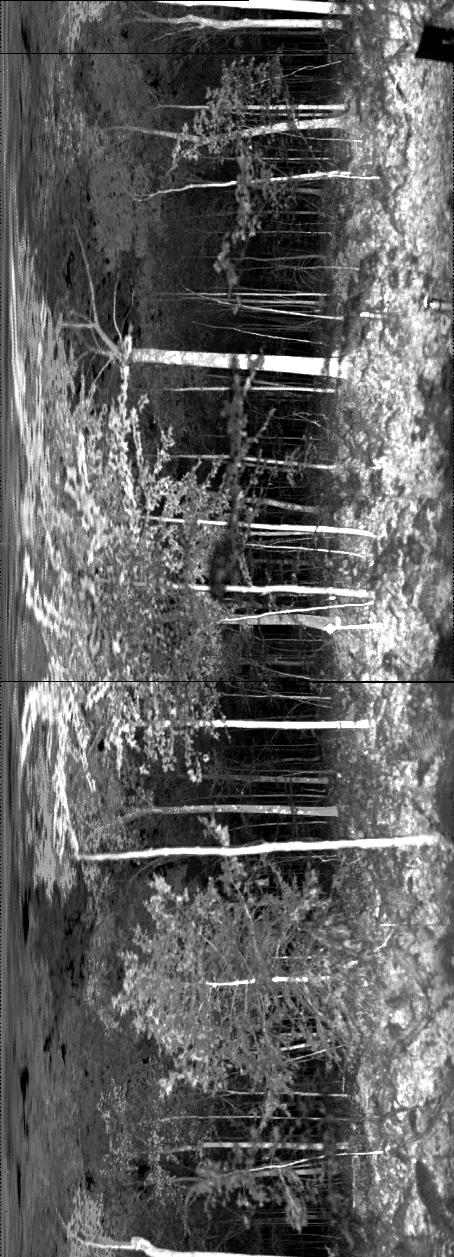
Federal
ECHIDNA LIDAR Campaigns: Forest Canopy Imagery and Field Data, U.S.A., 2007-2009
National Aeronautics and Space Administration —
This data set contains forest canopy scan data from the Echidna® Validation Instrument (EVI) and field measurements data from three campaigns conducted in the United... -
Federal
Ecology and Oceanography of Harmful Algal Blooms (ECOHAB)
National Aeronautics and Space Administration —
ECOHAB is a peer-reviewed, national, competitive program that funds regional-scale and targeted studies. Regional ecosystem investigations of the causes and impacts... -
Federal
ROSAT All-Sky Survey: Hyades Cluster Region
National Aeronautics and Space Administration —
This catalog contains the results of a complete X-ray survey of the Hyades cluster region using X-ray data from the ROSAT All-Sky Survey (RASS) that was published by... -
Federal
WMAP Nine-Year Five-Band Point Source Catalog
National Aeronautics and Space Administration —
The Wilkinson Microwave Anisotropy Probe (WMAP) is designed to produce all-sky maps of the cosmic microwave background (CMB) anisotropy. The WMAP 9-Year Point Source... -
Federal
Omega Centauri Globular Cluster Chandra X-Ray Point Source Catalog
National Aeronautics and Space Administration —
The authors analyzed a ~ 70 ks Chandra Advanced CCD Imaging Spectrometer (ACIS) exposure of the globular cluster Omega Cen (NGC 5139). The ~ 17' x 17' field of view... -
Federal
NGC 4636 Chandra X-Ray Point Source Catalog
National Aeronautics and Space Administration —
This catalog lists the X-ray point-source population in the nearby Virgo elliptical galaxy NGC 4636 from three Chandra X-ray observations. These observations,... -
Federal
unWISE Catalog
National Aeronautics and Space Administration —
The unWISE Catalog contains the positions and fluxes of roughly two billion objects observed by the Wide-field Infrared Survey Explorer (WISE) over the full sky. The... -
Federal
Spitzer Extragalactic Representative Volume Survey CDFS 4.5 micron Catalog
National Aeronautics and Space Administration —
The "Spitzer Extragalactic Representative Volume Survey" (SERVS) Exploration Science program conducted deep IRAC 3.6 and 4.5 micron observations of five extragalactic... -
Federal
XMM-COSMOS X-Ray Selected Type-2 AGN
National Aeronautics and Space Administration —
This table contains the results from a study of the multi-wavelength (from the mid-infrared to the hard X-ray) properties of a sample of 255 spectroscopically... -
Federal
GHRSST Level 2P NAVO 1 m Depth Global Sea Surface Temperature version 3.0 from the Visible Infrared Imaging Radiometer Suite (VIIRS) on the NOAA-21 satellite
National Aeronautics and Space Administration —
The VIIRS_N21-NAVO-L2P-v3.0 dataset produced by the Naval Oceanographic Office (NAVO) derives the 1-meter depth Sea Surface Temperature (SST) from the Visible... -
Federal
Forest-BGC Model (OTTER)
National Aeronautics and Space Administration —
Steve Running's Forest-BGC Model -
Federal
Environmental Working Group Joint U.S.-Russian Arctic Sea Ice Atlas, Version 1
National Aeronautics and Space Administration —
The Environmental Working Group Joint U.S.-Russian Arctic Sea Ice Atlas is part of the NOAA@NSIDC Environmental Working Group (EWG) Atlases data collection.The EWG... -
Federal
Orion Nebula Cluster Chandra HRC X-Ray Point Source Catalog
National Aeronautics and Space Administration —
In the first of two companion papers on the Orion Nebula Cluster (ONC), the authors presented their analysis of a 63 ks Chandra HRC-I observation that yielded 742... -
Federal
Global Navigation Satellite System (GNSS) IGS Rapid Combined Satellite and Receiver 5-Minute Clock Solution (30-second resolution, daily files, generated daily) Product from NASA CDDIS
National Aeronautics and Space Administration —
This derived product set consists of Global Navigation Satellite System Rapid Satellite and Receiver Clock Product (30-second granularity, daily files, generated... -
Federal
Global Navigation Satellite System (GNSS) IGS Rapid Combined Orbit Solution (daily files, generated daily) Product from NASA CDDIS
National Aeronautics and Space Administration —
This derived product set consists of Global Navigation Satellite System Rapid Orbit Product (daily files, generated daily) from the NASA Crustal Dynamics Data... -
Federal
Global Navigation Satellite System (GNSS) IGS Rapid Orbit/Clock/Earth Rotation Parameters (ERP) Product Summary from NASA CDDIS
National Aeronautics and Space Administration —
This derived product set consists of Global Navigation Satellite System Rapid Orbit/Reference Frame Product Summary from the NASA Crustal Dynamics Data Information...

Official websites use .gov
A
.gov website belongs to an official government
organization in the United States.
Secure .gov websites use HTTPS
A
lock (
) or https:// means you’ve safely connected to
the .gov website. Share sensitive information only on official,
secure websites.